Spotter Lake

Last updated
Spotter Lake
Canada Ontario relief location map.jpg
Red pog.svg
Spotter Lake
Location of Spotter Lake in Ontario, Canada
Location Thunder Bay District, Ontario, Canada
Coordinates 48°40′46″N85°44′08″W / 48.67944°N 85.73556°W / 48.67944; -85.73556 [1] Coordinates: 48°40′46″N85°44′08″W / 48.67944°N 85.73556°W / 48.67944; -85.73556 [2]
Type Lake
Max. length0.8 km (0.50 mi)
Max. width0.6 km (0.37 mi)
Surface area0.28 km2 (0.11 sq mi)
Surface elevation423 m (1,388 ft) [3]
Max. temperature16 °C (61 °F)
Min. temperature−19 °C (−2 °F)

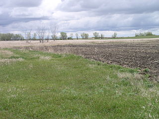
Spotter Lake is a lake located in the Thunder Bay region of Canada. It is 800km west of the capital, Ottawa. It covers 0.6 km from the north to the south and 0.8 km from the east to the west and had a total surface area of 0.28 km2.

Thunder Bay City in Ontario, Canada

Thunder Bay is a city in, and the seat of, Thunder Bay District, Ontario, Canada. It is the most populous municipality in Northwestern Ontario with a population of 107,909 as of the Canada 2016 Census, and the second most populous in Northern Ontario after Greater Sudbury. Located on Lake Superior, the census metropolitan area of Thunder Bay has a population of 121,621, and consists of the city of Thunder Bay, the municipalities of Oliver Paipoonge and Neebing, the townships of Shuniah, Conmee, O'Connor, and Gillies, and the Fort William First Nation.

Canada Country in North America

Canada is a country in the northern part of North America. Its ten provinces and three territories extend from the Atlantic to the Pacific and northward into the Arctic Ocean, covering 9.98 million square kilometres, making it the world's second-largest country by total area. Canada's southern border with the United States, stretching some 8,891 kilometres (5,525 mi), is the world's longest bi-national land border. Its capital is Ottawa, and its three largest metropolitan areas are Toronto, Montreal, and Vancouver. As a whole, Canada is sparsely populated, the majority of its land area being dominated by forest and tundra. Consequently, its population is highly urbanized, with over 80 percent of its inhabitants concentrated in large and medium-sized cities, with 70% of citizens residing within 100 kilometres (62 mi) of the southern border. Canada's climate varies widely across its vast area, ranging from arctic weather in the north, to hot summers in the southern regions, with four distinct seasons.

Ottawa Federal capital city in Ontario, Canada

Ottawa is the capital city of Canada. It stands on the south bank of the Ottawa River in the eastern portion of southern Ontario. Ottawa borders Gatineau, Quebec; the two form the core of the Ottawa–Gatineau census metropolitan area (CMA) and the National Capital Region (NCR). As of 2016, Ottawa had a city population of 934,243 and a metropolitan population of 1,323,783 making it the fourth-largest city and the fifth-largest CMA in Canada.

The surrounding area of the lake is mostly Mixed coniferous forest, and is mostly uninhabited. There are fewer than 2 inhabitants per square kilometre near the lake.

Mixed coniferous forest is a vegetation type dominated by a mixture of broadleaf trees and conifers. It is generally located in mountains, below the upper montane vegetation type.

Related Research Articles

Box Elder County, Utah County in the United States

Box Elder County is a county at the northwestern corner of Utah, United States. As of 2017, the estimated population is 54,079. Its county seat and largest city is Brigham City. The county was named for the box elder trees that abound in the county.

Potter County, South Dakota County in the United States

Potter County is a county in the U.S. state of South Dakota. As of the 2010 United States Census, the population was 2,329. Its county seat is Gettysburg. The county was created in 1873 and organized in 1883.

McCook County, South Dakota County in the United States

McCook County is a county in the U.S. state of South Dakota. At the 2010 United States Census, the population was 5,618. Its county seat is Salem. The county was established in 1873, and was organized in 1878. It was named for the former governor of the Dakota Territory and Civil War general Edwin Stanton McCook.

Jerauld County, South Dakota County in the United States

Jerauld County is a county in the U.S. state of South Dakota. As of the 2010 United States Census, the population was 2,071. Its county seat is Wessington Springs.

Edmunds County, South Dakota County in the United States

Edmunds County is a county in the U.S. state of South Dakota. As of the 2010 United States Census, the population was 4,071. Its county seat is Ipswich. The county was established in 1873 and organized in 1883. It is named for Newton Edmunds, second Governor of Dakota Territory.

Deuel County, South Dakota County in the United States

Deuel County is a county in the U.S. state of South Dakota. As of the 2010 United States Census, the population was 4,364. Its county seat is Clear Lake. The county was created in 1862, and was organized in 1878. It is named for Jacob Deuel, a legislator in 1862.

Clark County, South Dakota County in the United States

Clark County is a county in the U.S. state of South Dakota. As of the 2010 United States Census, the population was 3,691. Its county seat is Clark. The county was created in 1873 and organized in 1881. It was named for Newton Clark, a Dakota Territory legislator in 1873.

Charles Mix County, South Dakota County in the United States

Charles Mix County is a county in the U.S. state of South Dakota. As of the 2010 United States Census, the population was 9,129. Its county seat is Lake Andes. The county was created in 1862 and organized in 1879. It was named for Charles Eli Mix, an official of the Bureau of Indian Affairs influential in signing a peace treaty with the local Lakota Indian tribes. The easternmost approximately 60% of the county comprises the Yankton Indian Reservation.

Campbell County, South Dakota County in the United States

Campbell County is a county in the U.S. state of South Dakota. As of the 2010 United States Census, the population was 1,466, making it the fifth-least populous county in South Dakota. Its county seat is Mound City. The county was created in 1873 and organized in 1884. It was named for Norman B. Campbell, a Dakota Territory legislator in 1873 and son of General Charles T. Campbell.

Bon Homme County, South Dakota County in the United States

Bon Homme County is a county in the U.S. state of South Dakota. As of the 2010 United States Census, the population was 7,070. Its county seat is Tyndall.

Benson County, North Dakota County in the United States

Benson County is a county in the U.S. state of North Dakota. As of the 2010 United States Census, the population was 6,660. Its county seat is Minnewaukan. The county was created on March 9, 1883 by the Dakota Territory legislature, and was named for Bertil W. Benson, a Dakota Territory legislator at the time. The county government was organized on June 4, 1884, and its boundary lines were altered by two legislative actions in 1885.

Todd County, Minnesota County in the United States

Todd County is a county in the U.S. state of Minnesota. As of the 2010 United States Census, the population was 24,895. Its county seat is Long Prairie.

McLeod County, Minnesota County in the United States

McLeod County is a county in the U.S. state of Minnesota. At the 2010 United States Census, the population was 36,651. Its county seat is Glencoe.

Lincoln County, Minnesota County in the United States

Lincoln County is a county in the U.S. state of Minnesota. As of the 2010 United States Census, the population was 5,896. Its county seat is Ivanhoe.

Kandiyohi County, Minnesota County in the United States

Kandiyohi County is a county in the U.S. state of Minnesota. As of the 2010 United States Census, its population is 42,239. As of November 20, 1871, its county seat is Willmar.

Kanabec County, Minnesota County in the United States

Kanabec County is a county in the U.S. state of Minnesota. As of the 2010 United States Census, the population was 16,239. Its county seat is Mora.

Crow Wing County, Minnesota County in the United States

Crow Wing County is a county in the U.S. state of Minnesota. As of the 2010 United States Census, the population was 62,500. Its county seat is Brainerd. The county was formed in 1857, and was organized in 1870.

Carlton County, Minnesota County in the United States

Carlton County is a county in the State of Minnesota. As of the 2010 United States Census, the population was 35,386. Its county seat is Carlton. The county was formed in 1857 and organized in 1870. It was named for Reuben B. Carlton, a member of the Minnesota Senate (1857-58). Part of the Fond du Lac Indian Reservation lies in NE Carlton County.

Brown County, Minnesota County in the United States

Brown County is a county in the U.S. state of Minnesota. As of the 2010 United States Census, the population was 25,893. Its county seat is New Ulm. The county was formed in 1855 and organized in 1856.

Algonquin, Illinois Village in Illinois, United States

Algonquin is a village in McHenry and Kane counties, Illinois, in the United States. It is a suburb of Chicago, located approximately 40 miles (64 km) northwest of the Loop. As of the 2010 census the village's population was 30,046, and as of 2017 the estimated population was 31,017.

References

  1. "GeoNames.org". www.geonames.org. Retrieved 14 March 2019.
  2. "GeoNames.org". www.geonames.org. Retrieved 14 March 2019.
  3. "mapcarta.com" . Retrieved 18 March 2019.