Taylor County is a county in the U.S. state of Wisconsin. As of the 2010 census, the population was 20,689. Its county seat is Medford.

Scouting in Wisconsin has a long history, from the 1910s to the present day, serving thousands of youth in programs that suit the environment in which they live.

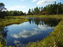
The Chequamegon–Nicolet National Forest is a 1,530,647-acre (6,194.31 km2) U.S. National Forest in northern Wisconsin in the United States. Much of the old growth forest in this region was destroyed by logging in the early part of the 20th century. Some of the trees that grow there today were planted by the Civilian Conservation Corps in the 1930s. The national forest lands contain trees and vegetation corresponding to the North Woods Ecoregion that is prevalent throughout the upper Great Lakes region.
The Menominee River is a river in northwestern Michigan and northeastern Wisconsin in the United States. It is approximately 116 miles (187 km) long, draining a rural forested area of northern Wisconsin and the Upper Peninsula of Michigan into Lake Michigan. Its entire course, with that of its tributary, the Brule River, forms part of the boundary between the two states.

Voyageurs National Park is an American national park in northern Minnesota near the town of International Falls established in 1975. The park's name commemorates the voyageurs—French-Canadian fur traders who were the first European settlers to frequently travel through the area. The park is notable for its outstanding water resources and is popular with canoeists, kayakers, other boaters, and fishermen. The Kabetogama Peninsula, which lies entirely within the park and makes up most of its land area, is accessible only by boat. To the east of the park lies the Boundary Waters Canoe Area Wilderness.
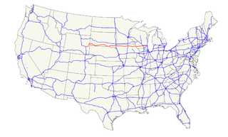
U.S. Route 18 is an east–west U.S. highway in the Midwestern United States. The western terminus is in Orin, Wyoming at an interchange with Interstate 25. Its eastern terminus is in downtown Milwaukee, Wisconsin. However, US 18 runs concurrent with other U.S. routes from its western terminus to Mule Creek Junction, Wyoming.

The Driftless Area is a region in southwestern Wisconsin, southeastern Minnesota, northeastern Iowa, and the extreme northwestern corner of Illinois, of the American Midwest. The region escaped the flattening effects of glaciation during the last ice age and is consequently characterized by steep, forested ridges, deeply carved river valleys, and karst geology characterized by spring-fed waterfalls and cold-water trout streams. Ecologically, the Driftless Area's flora and fauna are more closely related to those of the Great Lakes region and New England than those of the broader Midwest and central Plains regions. Colloquially, the term includes the incised Paleozoic Plateau of southeastern Minnesota and northeastern Iowa. The region includes elevations ranging from 603 to 1,719 feet at Blue Mound State Park and covers 24,000 square miles (62,200 km2). The rugged terrain is due both to the lack of glacial deposits, or drift, and to the incision of the upper Mississippi River and its tributaries into bedrock.

Wild River State Park is a state park of Minnesota, United States, curving along 18 miles (29 km) of the St. Croix River. This long, narrow park is shaped somewhat like a sideways 'S', with development largely concentrated in the lower third. The remote upper sections flank the mouth of a tributary called the Sunrise River. The park is managed to provide quieter, more nature-oriented recreation as a counterpoint to the busier William O'Brien and Interstate State Parks downstream.

Grand Portage State Park is a state park at the northeastern tip of Minnesota, USA, on the Canada–United States border. It contains a 120-foot (37 m) waterfall, the tallest in the state, on the Pigeon River. The High Falls and other waterfalls and rapids upstream necessitated a historically important portage on a fur trade route between the Great Lakes and inland Canada. This 8.5-mile (13.7 km) path plus the site of forts on either end are preserved in nearby Grand Portage National Monument. The state park, held by the surrounding Grand Portage Indian Reservation and leased to the state of Minnesota for $1 a year, is the only U.S. state park jointly managed by a state and a Native American band. It is also the only Minnesota state park not owned by the state.

Jay Cooke State Park is a state park of Minnesota, United States, protecting the lower reaches of the St. Louis River. The park is located about 10 miles (16 km) southwest of Duluth and is one of the ten most visited state parks in Minnesota. The western half of the park contains part of a rocky, 13-mile (21 km) gorge. This was a major barrier to Native Americans and early Europeans traveling by canoe, which they bypassed with the challenging Grand Portage of the St. Louis River. The river was a vital link connecting the Mississippi waterways to the west with the Great Lakes to the east.

Little Pine State Park is a Pennsylvania state park on 2,158 acres (873 ha) in Cummings Township, Lycoming County, Pennsylvania in the United States. Little Pine State park is along 4.2 miles (6.8 km) of Little Pine Creek, a tributary of Pine Creek, in the midst of the Tiadaghton State Forest. A dam on the creek has created a lake covering 94 acres (38 ha) for fishing, boating, and swimming. The park is on Pennsylvania Route 4001, 4 miles (6.4 km) northeast of the unincorporated village of Waterville or 8 miles (13 km) southwest of the village of English Center. The nearest borough is Jersey Shore, Pennsylvania, about 15 miles (24 km) south at the mouth of Pine Creek on the West Branch Susquehanna River.

Minnesota is the northernmost state outside Alaska; its isolated Northwest Angle in Lake of the Woods is the only part of the 48 contiguous states lying north of the 49th parallel. Minnesota is in the U.S. region known as the Upper Midwest. The state shares a Lake Superior water border with Michigan and Wisconsin on the northeast; the remainder of the eastern border is with Wisconsin. Iowa is to the south, North Dakota and South Dakota are west, and the Canadian provinces of Ontario and Manitoba are north. With 87,014 square miles (225,370 km2), or approximately 2.26 % of the United States, Minnesota is the 12th largest state.

Chandler State Wayside is a state park in south-central Oregon in the United States. It is named in honor of Solomon and Hattie Chandler, who donated the land for the park. The park covers 85 acres (34 ha) of pine forest along a creek. The park provides restrooms and other basic facilities to accommodate the traveling public. Chandler State Wayside is administered by the Oregon Parks and Recreation Department.
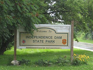
Independence Dam State Park is a 591-acre (239 ha) in Defiance County, Ohio in the United States. This Ohio state park lies on the banks of the Maumee River and features ruins of the Miami and Erie Canal. The park was established in 1949 and is open for year-round recreation including, boating, fishing, hiking and picnicking. It is off U.S. Route 24 just east of Defiance, Ohio.

Delaware State Park is a 2,016-acre (816 ha) Ohio state park in Delaware County, Ohio in the United States. The park, town and county are named for the Delaware Indians, a Native American tribe that originally lived along the Delaware River in Pennsylvania, Delaware, New York, Maryland, Connecticut and New Jersey. The Delawares were forced west by colonial settlers and were eventually forced further west by settlers of the Northwest Territory from which Ohio was established in 1803. Delaware State Park is on U.S. Route 23 near the city of Delaware, Ohio. It is open for year-round recreation including camping, hiking, boating, hunting, fishing, and picnicking.

The Tomahawk River is a river in the U.S. state of Wisconsin.

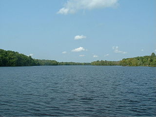
Tomahawk Lake is a lake in Oneida County, Wisconsin, United States. The lake covers an area of 3,392 acres (1,373 ha) and has a maximum depth of 84 feet (26 m). The community of Lake Tomahawk is located on the eastern edge of the lake. Tomahawk Lake was so named from the fact its outline resembles a tomahawk.

The Grass River is a historically important waterway in the Hudson Bay drainage basin in the Northern Region of Manitoba, Canada. It begins at the Cranberry Lakes approximately 27 kilometres (17 mi) east of Cranberry Portage and runs northeast 500 kilometres (310 mi) to its mouth on the Nelson River. The river was a critical route for earlier European explorers and was part of the "Upper Tract" of the fur trade into Canadian interior.

The Manitowish River is a river in Vilas County and Iron County in the state of Wisconsin in the United States. Its source is Fishtrap Lake near Boulder Junction. The conjunction of the Manitowish River and the Bear River is the source of the north fork of the Flambeau River. Historically the Manitowish River was an important part of an extensive network of canoe routes linked by short land portages, used by the Ojibwe and fur traders. In modern times the river and the lakes it connects are popular recreational waterways.

The Turtle River is a river in Vilas County and Iron County in the state of Wisconsin in the United States. Its source is South Turtle Lake near Winchester. It flows into the Turtle-Flambeau Flowage.