
Srikakulam is a city and the headquarters of Srikakulam district in the Indian state of Andhra Pradesh. As of 2011 census,. it has a population of 165,735. There are many other places of Buddhist Tourism such as Salihundam, Calinga Patnam, Dabbaka Vaani Peta, Nagari Peta, Jagati Metta, Singupuram etc. in Srikakulam District. The Buddhist heritage site of Salihundam has some unique features. It has a beautiful star atop a stupa, rock cut massive stupaas inside chaitya grihas, brick stupas with wheel pattern plan, votive stupas, inscriptions on the steps leading to the stupas and museum housing over two dozen sculpted statue and figurines of Buddha, Jain Teerthankars and other deities

Vizianagaram is a city and the headquarters of Vizianagaram district in the Indian state of Andhra Pradesh. It is central Eastern Ghats, about 24 km (15 mi) west of the Bay of Bengal and 40 km (25 mi) north-northeast of Visakhapatnam. The city has a population of 228,025 and was established as the capital of Vizianagaram estate by Raja Vijayaram Raj of Pusapati dynasty. The rulers had a notable role in the history of the region in 18th century and were patrons of education and arts.

Vizianagaram district is one of the nine districts in the Coastal Andhra region of the Indian state of Andhra Pradesh with its headquarters located at Vizianagaram. The district is bounded on the east by the district of Srikakulam, southwest by the City of Bheemunipatnam, southeast by the Bay of Bengal, and northwest by the state of Odisha. It was formed on 1 June 1979, with some parts carved from the neighbouring districts of Srikakulam and Visakhapatnam. The district is named after the princely state of Vizianagaram. It is the least populous district in Andhra Pradesh.

Srikakulam district is one of the nine districts in the Coastal Andhra region of the Indian state of Andhra Pradesh, with its headquarters located at Srikakulam. It is one of the nine coastal districts, located in the extreme northeastern direction of the state. It was formerly known as Chicacole.

Visakhapatnam district is one of the nine districts in the Coastal Andhra region of the Indian state of Andhra Pradesh, headquartered at Visakhapatnam. It is one of the nine coastal districts of the state, bounded by Odisha in the north, Vizianagaram district in the east, East Godavari district in the south-west and Bay of Bengal in the south.
Amadalavalasa is a town in Srikakulam district of the Indian state of Andhra Pradesh. It is a municipality and also the mandal headquarters of Amadalavalasa mandal. The town is spread over an area of 19.65 km2 (7.59 sq mi), which is under the jurisdiction of Visakhapatnam Metropolitan Region Development Authority. Srikakulam Road railway station is situated at Amadalavalasa.

Ichapuram is a town in the Srikakulam district of the Indian state of Andhra Pradesh. A Mendal headquarters, one of India's urban local bodies, governs the municipality. The town is located nearly 142 km from the district capital. Ichapuram municipality is the largest ULB in the Srikakulam District. It had a population of 36,493 as of 2011.

The River Nagavali also known as Langulya is one of the main rivers of Southern Odisha and Northern Andhra Pradesh States in India, between Rushikulya and Godavari basins.

Palasa is a town in Srikakulam district of the Indian state of Andhra Pradesh. It is a municipality and the mandal headquarters of Palasa mandal. It is located near to the National Highway 16 between Srikakulam and Berhampur. Along with its twin town Kasibugga
The Visakhapatnam Urban Development Authority or VUDA was the urban planning agency of Visakhapatnam, in the Indian state of Andhra Pradesh. It was formed in 1978, vide an act of the State Assembly of Andhra Pradesh. Its jurisdiction was expanded in 2018 by merging it with the surrounding mandals to form Visakhapatnam Metropolitan Region Development Authority.

The state of Andhra Pradesh has a coastline of 970 km2 (370 sq mi) and hence, there exist many beaches. The seacoast extends along the Bay of Bengal from Srikakulam district to Nellore district.
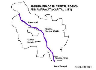
Andhra Pradesh Capital Region is the metropolitan region area surrounding Amaravati, the defacto capital city of Andhra Pradesh. It includes the major ancient cities of Vijayawada, Guntur, and Tenali. Andhra Pradesh Capital Region is one of the largest populated urban areas in the world, with its suburbs Vijayawada, Guntur, and Tenali being the 3rd, 24th, 41st most densely populated cities in the world. Vijayawada is the most densely populated city in India while Guntur is 11th and Tenali is the most populated city of 14th place in Andhra Pradesh. Andhra Pradesh Capital Region is the most populated metropolitan area in the state of Andhra Pradesh and 8th in India. Entire region is under the jurisdiction of Andhra Pradesh Capital Region Development Authority, and covers an area of 8,603 km2 (3,322 sq mi) under 58 mandals, of which 29 are in Krishna district and 29 in Guntur district. The capital region covers 18 mandals fully and 11 mandals partially in Guntur district. In Krishna district, it covers 15 mandals fully and 14 mandals partially under the jurisdiction of APCRDA. The capital city is an Urban Notified Area, and will cover 217.23 km2 (83.87 sq mi), within the Andhra Pradesh Capital Region. As of 1, August 2020, Andhra Pradesh proposed three capitals, which are Visakhapatnam as the executive capital, Amaravati as the legislative capital, and Kurnool as the judicial capital but the process is put on hold by High court and extended status quo till further orders.

The Andhra Pradesh Capital Region Development Authority, Amaravati, ACT No. 27 of 2020. It was notified on 31 July 2020 by the Government of Andhra Pradesh as per The Andhra Pradesh Capital Region Development Authority Repeal Act, 2020, it replaced the Andhra Pradesh Capital Region Development Authority Act, 2014.
Vizianagaram Municipal Corporation is the civic body that governs the city of Vizianagaram in the Indian state of Andhra Pradesh. The municipality was first constituted in the year 1888 and was upgraded to corporation on 9 December 2015.

Visakhapatnam Metropolitan Region is the metropolitan area covered by the city of Visakhapatnam in the Indian state of Andhra Pradesh. The entire region is spread over the districts of Visakhapatnam and Vizianagaram. Under the jurisdiction of Visakhapatnam Metropolitan Region Development Authority, it covers an area of 7,328.86 km2 (2,829.69 sq mi) and has a population of 60 lakhs.
The Bobbili Urban Development Authority (BUDA) is an urban planning agency in Vizianagaram district of the Indian state of Andhra Pradesh. It was constituted on 12 February 2019, under Andhra Pradesh Metropolitan Region and Urban Development Authorities Act, 2016 with the headquarters located at Bobbili.
The Chittoor Urban Development Authority is an urban planning agency in Chittoor district of the Indian state of Andhra Pradesh. It was constituted on 12 February 2019, under Andhra Pradesh Metropolitan Region and Urban Development Authorities Act, 2016 with the headquarters located at Chittoor.
South Coast Railway Zone (SCoR) has been announced as the newest railway zone of the Indian Railways and is headquartered at Visakhapatnam, Andhra Pradesh. The formal notification for operationalization of this Zone is yet to be issued.