
Coos Bay is an estuary where the Coos River enters the Pacific Ocean, the estuary is approximately 12 miles long and up to two miles wide. It is the largest estuary completely within Oregon state lines. The Coos Bay watershed covers an area of about 600 square miles and is located in northern Coos County, Oregon, in the United States. The Coos River, which begins in the Oregon Coast Range, enters the bay from the east. From Coos River, the bay forms a sharp loop northward before arching back to the south and out to the Pacific Ocean. Haynes Inlet enters the top of this loop. South Slough branches off from the bay directly before its entrance into the Pacific Ocean. The bay was formed when sea levels rose over 20,000 years ago at the end of the Last Glacial Maximum, flooding the mouth of the Coos River. Coos Bay is Oregon's most important coastal industrial center and international shipping port, with close ties to San Francisco, the Columbia River, Puget Sound and other major ports of the Pacific rim.

Ceathrú Thaidhg is a Gaeltacht village and townland on the Dún Chaocháin peninsula in northwestern County Mayo, Ireland. It is within Kilcommon parish in the barony of Erris. Carrowteige is a relatively small townland with an acreage of just 403 acres (1.63 km2).

Erris is a barony in northwestern County Mayo in Ireland consisting of over 230,452 acres (932.61 km2), much of which is mountainous blanket bog. It has extensive sea coasts along its west and north boundaries. The main towns are Belmullet and Bangor Erris. The name Erris derives from the Irish 'Iar Ros' meaning 'western promontory'. The full name is the Iorrais Domnann, after the Fir Bolg tribe, the Fir Domnann. To its north is the wild Atlantic Ocean and the bays of Broadhaven and Sruth Fada Conn and to its west is Blacksod Bay. Its main promontories are the Doohoma Peninsula, Mullet Peninsula, Erris Head, the Dún Chiortáin and Dún Chaocháin peninsulas and Benwee Head.

The Corrib gas project is a developed natural gas deposit located in the Atlantic Ocean, approximately 83 kilometres (52 mi) off the northwest coast of County Mayo, Ireland. The project includes a natural gas pipeline and an onshore gas processing plant, which commenced gas production in 2015. During its development, the project attracted considerable opposition.
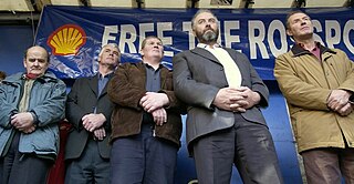
The Rossport Five are Willie Corduff, brothers Philip and Vincent McGrath, Micheál Ó Seighin and James Brendan Philbin, from Kilcommon parish, Erris, County Mayo, Ireland. In 2005, they were jailed for civil contempt of court after refusing to obey a temporary court injunction forbidding them to interfere with work being undertaken by Shell on their land.
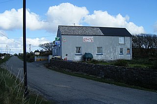
Rossport is a Gaeltacht village and townland in northwest County Mayo, Ireland. It is within the barony of Erris and parish of Kilcommon. It lies close to the mouth of Broadhaven Bay on the headland where the confluence of three rivers meet flowing into Sruth Fada Conn Bay. Its area is 1,446 acres (5.85 km2).

Glenamoy is a village in the civil parish of Kilcommon, Erris in the northern part of County Mayo in Ireland. Glenamoy is also an electoral division in the local electoral area of Belmullet. It is a Gaeltacht area. The R314 road passes through Glenamoy.

Shell to Sea is an Irish organisation based in the parish of Kilcommon in Erris, County Mayo.
Willie Corduff is an Irish environmental activist from the farming community of Rossport, Kilcommon, Erris. Corduff's parents first arrived in Rossport in 1947, and reclaimed a farm by hand out of bogland. He became a campaigner against Royal Dutch Shell's activities in his local area when the Corrib gas controversy began. He is married to Mary and they have six children and four grandchildren.

The San Francisco Estuary together with the Sacramento–San Joaquin River Delta represents a highly altered ecosystem. The region has been heavily re-engineered to accommodate the needs of water delivery, shipping, agriculture, and most recently, suburban development. These needs have wrought direct changes in the movement of water and the nature of the landscape, and indirect changes from the introduction of non-native species. New species have altered the architecture of the food web as surely as levees have altered the landscape of islands and channels that form the complex system known as the Delta.

The Corrib gas controversy was a social protest campaign against the Corrib gas project in north-western County Mayo, Ireland. The project involves the processing of gas onshore through Broadhaven and Sruth Fada Conn Bays in Kilcommon. Originally spearheaded by local advocacy groups Shell to Sea and Pobal Chill Chomáin, the protests later grew to national prominence due to the heavy-handed approach taken by the Garda Síochána and private security firms towards the protestors. The project was jointly managed by Shell E&P Ireland and Statoil Exploration Limited, and supported by the Irish government.
Pobal Chill Chomáin is a pressure group based in the parish of Kilcommon in County Mayo, Ireland. It split from the larger Shell to Sea campaign in April 2008. Vincent McGrath, one of the Rossport Five, is its chairman.

Glengad is a Gaeltacht village in the parish of Kilcommon in northwest County Mayo, Ireland. It is also known as Dooncarton, a name which comes from an Iron Age tribal chieftain called Ciortan, a character who appears in the Ulster Cycle legend of the Táin Bó Flidhais.

The Irish Sea is a 46,007 km2 (17,763 sq mi) body of water that separates the islands of Ireland and Great Britain. It is linked to the Celtic Sea in the south by St George's Channel and to the Inner Seas off the West Coast of Scotland in the north by the North Channel. Anglesey, North Wales, is the largest island in the Irish Sea, followed by the Isle of Man. The term Manx Sea may occasionally be encountered.

Kilcommon is a civil parish in Erris, north County Mayo, consisting of two large peninsulas; Dún Chaocháin and Dún Chiortáin. It consists of 37 townlands, some of which are so remote that they have no inhabitants. Habitation is concentrated mainly along both sides of Sruwaddacon Bay which flows into Broadhaven Bay, in villages including Glengad, Pollathomas, Rossport, Inver and Carrowteige, and in the Glenamoy area further inland.

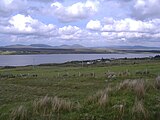
Broadhaven Bay is a natural bay of the Atlantic Ocean on the northwestern coast of County Mayo, Ireland. The opening of the bay faces northward, stretching 8.6 km between Erris Head in the west and Kid Island/Oileán Mionnán in the east.
The civil parish of Kilcommon in Erris, northern County Mayo, Ireland has a total of 37 townlands: small geographic divisions of land in Ireland and Scotland's Outer Hebrides. Townlands originated in Gaelic Ireland, and predate the late-12th-century Anglo-Norman invasion. However, some townland names are derived from British plantations and Norman manors.

The Glenamoy River is a river in north County Mayo, in the northwest of Ireland. It is renowned for its stocks of sea trout and salmon.
Milford Haven Waterway, is a Site of Special Scientific Interest (SSSI) on Milford Haven Waterway in Pembrokeshire, South Wales, designated since 2002. The site is protected for a wide range of reasons, including its geology, marine environment and ecosystems, and to protect a diversity of flora and fauna.
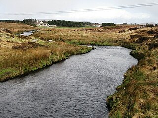
The Muingnabo River is a river in north County Mayo, in the northwest of Ireland. It flows into the Atlantic Ocean via Sruwaddacon Bay.
 Upper reaches of estuary at Aughoose
 Rossport Pier
 Dolphins in Sruwaddacon Estuary
 Bottlenose dolphins play in the Bay


