Related Research Articles

Caesar Rodney was an American Founding Father, lawyer, and politician from St. Jones Neck in Dover Hundred, Kent County, Delaware. He was an officer of the Delaware militia during the French and Indian War and the American Revolutionary War, a Continental Congressman from Delaware, a signer of the Continental Association and Declaration of Independence, and president of Delaware during most of the American Revolution.
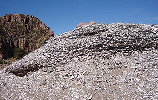
A midden is an old dump for domestic waste which may consist of animal bone, human excrement, botanical material, mollusc shells, potsherds, lithics, and other artifacts and ecofacts associated with past human occupation.

Native American pottery is an art form with at least a 7500-year history in the Americas. Pottery is fired ceramics with clay as a component. Ceramics are used for utilitarian cooking vessels, serving and storage vessels, pipes, funerary urns, censers, musical instruments, ceremonial items, masks, toys, sculptures, and a myriad of other art forms.
Thomas "Tommy" Rodney was an American lawyer and politician from Jones Neck in St. Jones Hundred, Kent County, Delaware, and Natchez, Mississippi. He was a Continental Congressman from Delaware, and a member of the Democratic-Republican Party who served in the Delaware General Assembly, as Justice of the Delaware Supreme Court, and as federal judge for the Mississippi Territory. He was the younger brother of Caesar Rodney, Revolutionary President of Delaware.
In the classification of archaeological cultures of North America, the Woodland period of North American pre-Columbian cultures spanned a period from roughly 1000 BCE to European contact in the eastern part of North America, with some archaeologists distinguishing the Mississippian period, from 1000 CE to European contact as a separate period. The term "Woodland Period" was introduced in the 1930s as a generic term for prehistoric sites falling between the Archaic hunter-gatherers and the agriculturalist Mississippian cultures. The Eastern Woodlands cultural region covers what is now eastern Canada south of the Subarctic region, the Eastern United States, along to the Gulf of Mexico.
The Prehistory of West Virginia spans ancient times until the arrival of Europeans in the early 17th century. Hunters ventured into West Virginia's mountain valleys and made temporary camp villages since the Archaic period in the Americas. Many ancient human-made earthen mounds from various mound builder cultures survive, especially in the areas of Moundsville, South Charleston, and Romney. The artifacts uncovered in these areas give evidence of a village society with a tribal trade system culture that included limited cold worked copper. As of 2009, over 12,500 archaeological sites have been documented in West Virginia.
The Lambert Farm Site, designated RI-269, was a prehistoric archaeological site in Warwick, Rhode Island, United States. The site consisted of a large shell midden and a dispersed collection of associated stone artifacts at an inland location, which were dated to the Late Woodland Period. The site was examined by professional archaeologists in 1980, and was added to the National Register of Historic Places in 1983 for its potential to reveal information about prehistoric land use patterns. It was destroyed in 1991 by residential development of the area, although significant quantities of archaeological material were recovered prior to its destruction.

Agriculture in Scotland includes all land use for arable, horticultural or pastoral activity in Scotland, or around its coasts. The first permanent settlements and farming date from the Neolithic period, from around 6,000 years ago. From the beginning of the Bronze Age, about 2000 BCE, arable land spread at the expense of forest. From the Iron Age, beginning in the seventh century BCE, there was use of cultivation ridges and terraces. During the period of Roman occupation there was a reduction in agriculture and the early Middle Ages were a period of climate deterioration resulting in more unproductive land. Most farms had to produce a self-sufficient diet, supplemented by hunter-gathering. More oats and barley were grown, and cattle were the most important domesticated animal. From c. 1150 to 1300, the Medieval Warm Period allowed cultivation at greater heights and made land more productive. The system of infield and outfield agriculture may have been introduced with feudalism from the twelfth century. The rural economy boomed in the thirteenth century, but by the 1360s there was a severe falling off in incomes to be followed by a slow recovery in the fifteenth century.

The Deptford culture was an archaeological culture in southeastern North America characterized by the appearance of elaborate ceremonial complexes, increasing social and political complexity, mound burial, permanent settlements, population growth, and an increasing reliance on cultigens.

The Saugeen complex was a Native American culture located around the southeast shores of Lake Huron and the Bruce Peninsula, around the London area, and possibly as far east as the Grand River. They were active in the period 200BCE to 500CE. There is archeological evidence that the Saugeen complex people of the Bruce Peninsula may have evolved into the Odawa people (Ottawa).

The Sommerheim Park Archaeological District includes a group of six archaeological sites west of Erie, Pennsylvania in the United States. The sites are in Sommerheim Park, one of the few undeveloped areas of the Lake Erie shoreline, in Millcreek Township. This district has been listed on the National Register of Historic Places. This is one of the leading archaeological sites in the Erie area and along the southern shoreline of Lake Erie, due to the amount of artifacts and the lack of disturbance on the site.

The Neolithic period in the British Isles lasted from c. 4000 to c. 2,500 BCE. Constituting the final stage of the Stone Age in the region, it was preceded by the Mesolithic and followed by the Bronze Age.

Pearsons Corner is an unincorporated community in Kent County, Delaware, United States. Pearsons Corner is located at the intersection of state routes 8 and 44, west of Dover.
The Carey Farm Site (7K-D-3) is a prehistoric Native American archaeological site in central Kent County, Delaware, near Dover. The site, located along the St. Jones River, encompasses what is believed to be a major seasonal base camp from the Woodland Period. Ceramics dating back to 200 CE have been found at the site.
The Byfield Historic District encompasses the remains of an early colonial community in eastern Kent County, in the U.S. state of Delaware. The district includes four separate archaeological sites, each of which have been associated with early English settlers of the area. The site designated K-929 is the location of a brick kiln, which documentary evidence suggests was associated with Daniel Jones, the first settler in the area. K-917 is speculated to be associated with William Rodney, who married Jones' daughter. K-916 is a site that may have been a slave residence, and K-890 is believed to be the site of one of the homes of Caesar Rodney, Sr., the father of Delaware Revolutionary War leader Caesar Rodney. The only 19th century structure in the district is the S. A. Sipple House.

The Lower St. Jones Neck Historic District encompasses an expansive area of eastern Kent County, Delaware, east of Dover, Delaware. It is prominent in part for its association with the politically powerful Dickinson family, and in particular John Dickinson, the statesman of Pennsylvania and Delaware. Most of the land in the district was owned in the late 18th and early 19th centuries by Dickinson, who built a summer house at Logan Lane Farm early in the 19th century, and an overseer's house now called the Dickinson Mansion. The area has remained in the hands of Dickinson descendants into the 20th century.
The Indian River Archeological Complex is a collection of archaeological sites near Millsboro, Delaware, encompassing what is the only known riverine settlement in Sussex County during the Middle Woodland Period. It consists of three separate sites, 7S-F-11, 7S-F-12, and 7S-F-13. These sites appear to have been semi-permanent seasonal settlements, occupied during the spring and fall, and abandoned for other hunting and fishing grounds in the summer and winter. Finds at each site include both worked stone artifacts including projectile points, as well as different types of ceramics. The combination of finds raises questions about the pattern of cultural migration in the area, which further investigation of the sites may shed light on. Of the three sites, two have been subjected to surface-level collection, and one, 7S-F-13, has been subjected to more intensive excavations.

Agriculture in prehistoric Scotland includes all forms of farm production in the modern boundaries of Scotland before the beginning of the early historic era. Scotland has between a fifth and a sixth of the arable or good pastoral land of England and Wales, mostly in the south and east. Heavy rainfall encouraged the spread of acidic blanket peat bog, which with wind and salt spray, made most of the western islands treeless. Hills, mountains, quicksands and marshes made internal communication and agriculture difficult.

The Moccasin Bluff site is an archaeological site located along the Red Bud Trail and the St. Joseph River north of Buchanan, Michigan. It was listed on the National Register of Historic Places in 1977, and has been classified as a multi-component prehistoric site with the major component dating to the Late Woodland/Upper Mississippian period.

The Cornish Bronze Age is an era of the history of Cornwall that spanned the period from c. 2400 BCE to c. 800 BCE. It was preceded by the Cornish Neolithic, and followed by the Cornish Iron Age. It is characterized by the introduction and widespread use of copper and copper-alloy (bronze) weapons and tools.
References
- 1 2 3 4 "St. Jones Neck Multiple Resource Area Document". National Park Service . Retrieved April 2, 2014.