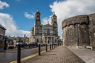
Athlone is a town on the border of County Roscommon and County Westmeath, Ireland. It is located on the River Shannon near the southern shore of Lough Ree. It is the second most populous town in the Midlands Region with a population of 22,869 in the 2022 census.

Rochfortbridge is a village in County Westmeath, Ireland. The village is located at the intersection of the R400 and the R446 roads. As of the 2016 census, the population of Rochfortbridge was 1,473.
Athlone was a parliamentary constituency in Ireland, which from 1801 to 1885 returned one Member of Parliament (MP) to the House of Commons of the United Kingdom of Great Britain and Ireland.
Brosna is a village and parish situated in the Sliabh Luachra area of County Kerry, Ireland. It lies 16 km (9.9 mi) from the town of Castleisland. The civil parish of Brosna consists of the village and a number of townlands. It is a mainly agricultural area, supporting two churches, two schools, a post office, and five public houses.

Cloghan is a town in County Offaly, Ireland. It is located, in the civil parish of Gallen, at the intersection of the N62 National secondary road and the R356 and R357 regional roads. As of the 2022 census, Cloghan had a population of 654 people.
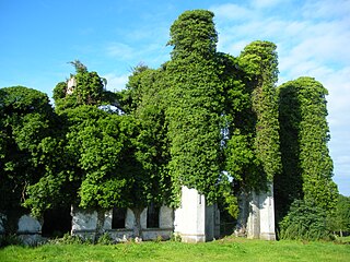
Moydrum Castle is a ruined castle situated in the townland of Moydrum in County Westmeath in Ireland, just to the east of Athlone. The property is privately owned.

Moygownagh or Moygawnagh is a civil parish and village in the historical barony of Tyrawley, County Mayo, Ireland. Moygownagh borders the parishes of Kilfian and Crossmolina.

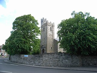
Ballinahown, also spelled Ballynahown, is a village in County Westmeath in Ireland. On the N62 road, it is 10 km (6.2 mi) south of Athlone and 5 km (3.1 mi) east of the River Shannon. It contains the Roman Catholic St. Colmcilles Church, completed in 1902 to a design in the Early English Gothic-style by William Hague.

Arles or Arless is a village in County Laois, Ireland. It lies 2 kilometres (1.2 mi) northwest of Ballickmoyler and 10 km (6 mi) northwest of Carlow, on the N80 national secondary road.
Drumcar is a village and a historical parish, in the barony of Ardee in County Louth, Ireland.

Ankers Bower is a townland and hill in St. Mary's civil parish in the barony of Brawny, County Westmeath, Ireland. It is partly within the former urban district of Athlone. The name may derive from John Ankers, who was vicar of St. Mary's in 1608.

Lickbla, is a historic monument, civil parish, religious parish, and townland, in County Westmeath, Ireland. It is located about 23.05 kilometres (14 mi) north of Mullingar. St. Bladma is listed in the Martyrology of Oengus as a saint: "Bladma, i.e. from Blad son of Conmac Cas Clothach, grandson of Tachall son of Cermait, son of the Dagda, a quo nominatur. Or Blad son of Breogan, a quo Sliab Bladma" whose feastday is 7 April and 20 November.
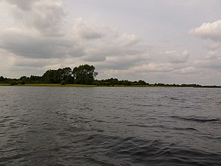
Inchbofin is an island situated in Lough Ree on the River Shannon, in central Ireland.

Castlemagner is a village, townland and civil parish in the Duhallow area of north-west County Cork, Ireland. Castlemagner is within the Cork North-West.

Ballinea or Ballina, is a village and townland in County Westmeath, Ireland. It is located to the west of Mullingar, on the R390 road. The Royal Canal flows through the village, with the Ballinea Bridge being used to cross to the western side.

James Rawson Carroll, FRIA was an Irish architect who was involved in many projects throughout Ireland during the Victorian Era. He was a founding partner of the Carroll & Batchelor architectural firm in 1892, alongside Frederick Batchelor.
Killeenagarriff is a civil parish in the historical barony of Clanwilliam in County Limerick, Ireland. Settlements in Killeenagarriff include the town of Annacotty, and population centres at Ahane and Barringtonsbridge.
St Mary's is a Church of Ireland church in Crumlin, Dublin, Ireland. It is included on the Record of Protected Structures maintained by Dublin City Council.
Balrath Demesne is a townland in County Meath, Ireland. It is located 4 km (2.5 mi) southwest of the town of Kells. Its population was 36 in 2011. The wall of an ancient chapel and a cemetery remain here, on the grounds of the former estate, Balrath Bury.

