Related Research Articles

Refugio County is a county located in the U.S. state of Texas. As of the 2020 census, its population was 6,741. Its county seat is Refugio. The county originated as a municipality of Mexico in 1834 and was classified as a county in 1837.
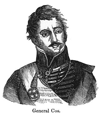
Martín Perfecto de Cos was a Mexican Army general and politician during the mid-19th century. Born in Veracruz, the son of an attorney, he became an army cadet at the age of 20, a Lieutenant in 1821, and a Brigadier General in 1833.

The Battle of Goliad was the second skirmish of the Texas Revolution. In the early-morning hours of October 9, 1835, Texas settlers attacked the Mexican Army soldiers garrisoned at Presidio La Bahía, a fort near the Mexican Texas settlement of Goliad. La Bahía lay halfway between the only other large garrison of Mexican soldiers and the then-important Texas port of Copano.
The Aransas River is a short river in south Texas in the United States. It drains an area of the south Texas coastal plains into the Gulf of Mexico. It rises in Bee County southwest of Beeville and north of Skidmore, from the confluence of three creeks: Olmos, Aransas, and Poesta. It flows generally south and southeast in a highly winding course, entering Copano Bay on the Gulf of Mexico along the Refugio-Aransas county line, approximately 10 miles (16 km) northwest of Rockport.

Aransas Bay is a bay on the Texas Gulf Coast, approximately 30 miles (48 km) northeast of Corpus Christi, and 173 miles (278 km) south of San Antonio. It is separated from the Gulf of Mexico by San José Island. Aransas Pass is the most direct navigable outlet into the Gulf of Mexico from the bay. The cities of Aransas Pass and Port Aransas are located at the southern end, and Rockport is found on the central western shore. The bay is oriented laterally northeast–southwest, and is extended by Redfish Bay to the southwest, Copano Bay to the west, Saint Charles Bay to the north, and Mesquite Bay to the northeast. Aransas Bay is part of the Mission-Aransas National Estuarine Research Reserve.
North American area code 361 is a state of Texas telephone area code for numbers in the Corpus Christi area, the Coastal Bend and the Victoria Crossroads. It was created prior to February 13, 1999, in a split from area code 512.

San Antonio Bay is a bay on the Texas Gulf Coast situated between Matagorda and Aransas Bay. It consists mainly of the combined waters of the San Antonio and Guadalupe rivers, and is located at the mouth of the Guadalupe River, about 55 miles (89 km) northeast of Corpus Christi and 130 miles (209 km) southeast of San Antonio. It is protected from the Gulf of Mexico by Matagorda Island, leaving only relatively small and distant outlets to the Gulf for little mixing of bay and Gulf waters. The remoteness of the bay has prevented the establishment of major ports as seen on Aransas Bay and Corpus Christi Bay, to the south.
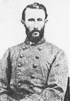
Alfred Marmaduke Hobby was a famous Texas merchant, politician, Confederate officer, and poet. He was born in Macon, Georgia, in 1836, the son of Martin and Anna Elizabeth (Slade) Hobby. Hobby's nephew is William P. Hobby, governor of Texas from 1917 to 1921. His grandnephew William P. Hobby, Jr., was lieutenant governor of Texas 1973-91.

Copano Bay is a northwestern extension of Aransas Bay, west of Rockport, Texas in Refugio and Aransas counties. It is supplied with seawater from the Gulf of Mexico via Aransas Bay, and fed freshwater from the Aransas River, Mission River and Copano Creek. As an estuary, the bay is home to a diverse ecosystem consisting of various birds including the endangered whooping crane, and numerous finfish including the redfish as well as shellfish such as oysters. It is classified as a nursery for shrimp, which prohibits production from the bay. Copano Bay is also a historic location for human usage and settlement that dates back to the 18th century, beginning with the historic port of El Copano and the 19th century settlements of St. Mary's of Aransas and Copano. The present-day towns of Bayside, Copano Village and Holiday Beach were all founded in the 20th century. Oil and natural gas are pumped from below the bay's surface, and contribute to the livelihood of the local economies. Recently, areas around the bay were affected by Hurricane Harvey which crossed over the bay as a Category 3 hurricane.
Lamar is a small, unincorporated community and census-designated place (CDP) in Aransas County, Texas, United States, 10 miles (16 km) north of Rockport and 40 miles (64 km) north of Corpus Christi. As of the 2010 census it had a population of 636. The community was named for Mirabeau B. Lamar, the second president of the Republic of Texas. This was a new CDP for the 2010 census.
The Battle of Lipantitlán, also known as the Battle of Nueces Crossing, was fought along the Nueces River on November 4, 1835 between the Mexican Army and Texian insurgents, as part of the Texas Revolution. After the Texian victory at the Battle of Goliad, only two Mexican garrisons remained in Texas, Fort Lipantitlán near San Patricio and the Alamo Mission at San Antonio de Béxar. Fearing that Lipantitlán could be used as a base for the Mexican army to retake Goliad and angry that two of his men were imprisoned there, Texian commander Philip Dimmitt ordered his adjutant, Captain Ira Westover, to capture the fort.

Clara Driscoll, was a Texas-born philanthropist. In 1967, a Texas Historical Marker honoring Driscoll was placed at 2312 San Gabriel Avenue, Austin. In 1978, Texas Historical Marker number 1287 honoring Driscoll was placed at the Driscoll Family Mausoleum, Alamo Masonic Cemetery, East Commerce St., San Antonio.
Holiday Beach is an unincorporated community and census-designated place in Aransas County, Texas, United States. As of the 2010 census it had a population of 514. This was a new CDP for the 2010 census.
St. Charles Bay is an inlet of Aransas Bay in Aransas County, Texas. It is flanked by Lamar peninsula on the west and Blackjack peninsula on the east. The bay hosts a valued ecosystem for the endangered whooping crane, and is a prime location for birding and fishing. Goose Island State Park and the Aransas National Wildlife Refuge are located along the bay's shores, attracting nature enthusiasts year-round.

Adina Emilia De Zavala was an American teacher, historian and preservationist of Texas history. Her efforts led to saving the Alamo Long Barrack Fortress for future generations. She was born to Augustine De Zavala, son of Lorenzo de Zavala, the first Vice President of the Republic of Texas. Adina's mother Julia Tyrrell De Zavala was born in Ireland. In 1994, Recorded Texas Historic Landmark Marker number 86 was placed at Alamo Plaza to honor De Zavala. In 2008, Texas Historical marker number 15124 was placed in St. Mary's Cemetery to honor De Zavala's contributions to Texas.
Copano is a ghost town on the northwestern shore of Copano Bay in Refugio County, Texas. It is located 5 mi (8.0 km) north of present-day Bayside, on Copano Point. The port, which holds the distinction as the first in South Texas, was founded in the early 18th century by the Spanish, and named for the Copane Indians who resided in the area. Initially, it was used as a port by smugglers and pirates, until 1785, when it was officially opened for use by the Spanish empire. The port was abandoned in the 1880s, following the settlement of the area after the Texas Revolution. Ruins of the town site can still be found, but are currently in danger of falling into Copano Bay.
Aransas City is a ghost town on the tip of the Live Oak Peninsula in Aransas County, Texas, United States, near present-day Fulton. It served as a port on Aransas Bay at its confluence with Copano Bay during the 1830s and 1840s, but declined following its loss of a Republic of Texas customhouse to the rival port of Lamar.
James Power was an Irish-born Texan empresario, politician and signer of the Texas Declaration of Independence, known for the land grant he received with partner James Hewetson that included the coastal area between the mouths of the Guadalupe and Nueces Rivers, as well as his founding and service as the first mayor of the Aransas City settlement. He often represented Refugio County during statewide conventions. Was part of the Mexican national era
James Hewetson was a Texas empresario.

The U.S. state of Texas has a series of estuaries along its coast on the Gulf of Mexico, most of them bounded by the Texas barrier islands. Estuaries are coastal bodies of water in which freshwater from rivers mixes with saltwater from the sea. Twenty-one drainage basins terminate along the Texas coastline, forming a chain of seven major and five minor estuaries: listed from southwest to northeast, these are the Rio Grande Estuary, Laguna Madre, the Nueces Estuary, the Mission–Aransas Estuary, the Guadalupe Estuary, the Colorado–Lavaca Estuary, East Matagorda Bay, the San Bernard River and Cedar Lakes Estuary, the Brazos River Estuary, Christmas Bay, the Trinity–San Jacinto Estuary, and the Sabine–Neches Estuary. Each estuary is named for its one or two chief contributing rivers, excepting Laguna Madre, East Matagorda Bay, and Christmas Bay, which have no major river sources. The estuaries are also sometimes referred to by the names of their respective primary or central water bodies, though each also includes smaller secondary bays, inlets, or other marginal water bodies.
References
- 1 2 Long, Christopher (November 11, 2009). "Aransas County". Handbook of Texas Online. Texas State Historical Association. Retrieved 17 August 2010.
- 1 2 3 Huson, Hobart (May 30, 2010). "St. Mary's of Aransas, Texas". Handbook of Texas Online. Texas State Historical Association. Retrieved 17 August 2010.
- ↑ Leffler, John (May 30, 2010). "Aransas County". Handbook of Texas Online. Texas State Historical Association. Retrieved 17 August 2010.
- ↑ Benowitz, June Melby (May 30, 2010). "Bayside, Texas". Handbook of Texas Online. Texas State Historical Association. Retrieved 17 August 2010.
- ↑ DeMoss, Dorothy D. (May 30, 2010). "Clara Driscoll". Handbook of Texas Online. Texas State Historical Association. Retrieved 17 August 2010.
- ↑ Huson, Hobart (May 30, 2010). "Alfred Marmaduke Hobby". Handbook of Texas Online. Texas State Historical Association. Retrieved 18 August 2010.
Municipalities and communities of Refugio County, Texas, United States | ||
|---|---|---|
| City | 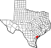 | |
| Towns | ||
| CDP | ||
| Ghost towns | ||