St. Peter's Dome

Last updated

St. Peter's Dome is a granite-topped peak on Pikes Peak massif in the Pike National Forest. [1] The peak, at 9,528 feet (2,904 m) in elevation, [2] is located in El Paso County, Colorado, above Colorado Springs. [1] It is located about 8 miles (13 km) from Colorado Springs along Old Stage and Gold Camp Roads. Old Stage Road is picked up behind The Broadmoor and Gold Camp Road winds through Cheyenne Canyon. [1] [3]

Pikes Peak mountain in the Rocky Mountains, Colorado, United States of America

Pikes Peak is the highest summit of the southern Front Range of the Rocky Mountains, in North America. The ultra-prominent 14,115-foot (4,302.31 m) fourteener is located in Pike National Forest, 12 miles (19 km) west of downtown Colorado Springs, Colorado. The mountain is named in honor of American explorer Zebulon Pike, who was unable to reach the summit. The summit is higher than any point in the United States east of its longitude.

Pike National Forest

The Pike National Forest is located in the Front Range of Colorado, United States, west of Colorado Springs including Pikes Peak. The forest encompasses 1,106,604 acres (4,478 km²) within Clear Creek, Teller, Park, Jefferson, Douglas and El Paso counties. The major rivers draining the forest are the South Platte and Fountain Creek. Rampart Reservoir, a large artificial body of water, is located within the forest.

El Paso County, Colorado county in Colorado, United States

El Paso County is one of the 64 counties of the U.S. state of Colorado. The 2017 census estimate recorded an approximate population of 699,232 for El Paso County. The Census Bureau's 2017 estimate indicates it is the second-most populous county in Colorado, after the City and County of Denver. The county seat is Colorado Springs, the second most populous city in Colorado.

Contents

The St. Peter's Dome mining district, also called the Cheyenne District, has been operational since 1910. In the early 20th century, trains stopped at the St. Peter's Dome for the trip between Cripple Creek and Colorado Springs. Tourists had picnics, hiked, and camped in the area.

Recreation

St. Peter's Dome can be climbed via a 2 miles (3.2 km) trail with a 400 feet (120 m) gain in altitude. The trail heads northwest from the parking lot by the sign for the St. Peter's Dome Shooting Range. One section of the trail is a vertical ascent that requires use of the knotted rope to climb 10 feet (3.0 m). From the ledge above, the trail continues to the summit where there is a view of the city of Colorado Springs and Cheyenne Mountain. It is not recommended for small children and dogs. [1]

There is rock climbing on nearby formations, such as the Aiguille de St. Peter formation. [3]

History

St. Peter's Dome and Colorado Springs and Cripple Creek District Railway 1910s St. Peter's Dome 1910s.jpg
St. Peter's Dome and Colorado Springs and Cripple Creek District Railway 1910s

In the early 20th century, the Colorado Springs and Cripple Creek District Railway (Short Line) passed from Cripple Creek through St. Peter's Dome to Colorado Springs. [1] In 1902, about 200,000 people took the train along the rim of South Cheyenne Cañon to Colorado Springs. [4] It was a picnic and camping site. [5] The vertical ascent of 10 feet (3.0 m) was first made by a wooden ladder and then a spiral staircase. It is now made by using a knotted rope. [1]

Colorado Springs and Cripple Creek District Railway

The Colorado Springs and Cripple Creek District Railway was a 4 ft 8 12 instandard gauge railroad operating in the U.S. state of Colorado around the turn of the 20th century.

South Cheyenne Cañon

South Cheyenne Cañon, or South Cheyenne Canyon, is a canyon in Colorado Springs, El Paso County, Colorado. The South Cheyenne Cañon road to Seven Falls is called "The Grandest Mile of Scenery" in Colorado. Seven Falls has been a tourist attraction since it was opened in the early 1880s. Trails from the top of the falls lead to Midnight Falls, near the headwaters of South Cheyenne Creek, and Inspiration Point. The area has been a center for parks, such as the Stratton Park and Colorado College Park. Now, part of South Cheyenne Cañon, including the Starsmore Discovery Center, is in the North Cheyenne Cañon Park. The area sustained a significant flood in September 2013, which has closed Seven Falls until Spring 2015.

There was also a trail for burro and pony rides to St. Peter's Dome. [6]

St. Peter's Dome District

First called Cheyenne District, the mining district of St. Peter's Dome, Stove Mountain, and Sugarloaf Mountain is more commonly known as St. Peter's Dome District. The latitude and longitude of the district are that of St. Peter's Dome. The district is at the sources of South Cheyenne Creek, Rock Creek and Little Fountain Creek. Mines include the Timberline, Mattie B., Eureka, and Duffields fluorspar mines. Others are the Trail Mines Prospect and St. Peter's Dome No. 1. [7] The mines primarily produced fluorine-fluorite, gold, silver, lead, and zinc. To a lesser degree, the following have been found include thorium, REE, gemstone, uranium, beryllium, titanium, tin, and niobium. [7] Cryolite was discovered there by October 1882. [8] [9] Ore or minerals were discovered in 1901. Mining began in 1910 and Kramer Mines purchased the mines in 1945. [7]

Cheyenne Creek river in the United States of America

Cheyenne Creek is a stream in Colorado Springs, El Paso County, Colorado at 5,920 feet (1,800 m) in elevation. The stream is fed by the North Cheyenne Creek and South Cheyenne Creek and flows into Fountain Creek near Nevada Avenue, between Interstate 25 and the Pikes Peak Greenway trail. North Cheyenne Creek and South Cheyenne Creek flow through Teller and El Paso Counties. The source of South Cheyenne Creek is Mount Big Chief, near St. Peter's Dome, and it flows to Seven Falls.

Cryolite perovskite, halide mineral (as opposed to the chemical compound)

Cryolite (Na3AlF6, sodium hexafluoroaluminate) is an uncommon mineral identified with the once large deposit at Ivigtût on the west coast of Greenland, depleted by 1987.

Related Research Articles

San Juan Mountains mountain range in Colorado, USA

The San Juan Mountains are a high and rugged mountain range in the Rocky Mountains in southwestern Colorado and northwestern New Mexico. The area is highly mineralized and figured in the gold and silver mining industry of early Colorado. Major towns, all old mining camps, include Creede, Lake City, Silverton, Ouray, and Telluride. Large scale mining has ended in the region, although independent prospectors still work claims throughout the range. The last large scale mines were the Sunnyside Mine near Silverton, which operated until late in the 20th century and the Idarado Mine on Red Mountain Pass that closed down in the 1970s. Famous old San Juan mines include the Camp Bird and Smuggler Union mines, both located between Telluride and Ouray.

Cripple Creek, Colorado Statutory City in Colorado, United States

Cripple Creek is the Statutory City that is the county seat of Teller County, Colorado, United States. The city population was 1,189 at the 2010 United States Census. Cripple Creek is a former gold mining camp located 44 miles (71 km) southwest of Colorado Springs near the base of Pikes Peak. The Cripple Creek Historic District, which received National Historic Landmark status in 1961, includes part or all of the city and the surrounding area. The city is now a part of the Colorado Springs, CO Metropolitan Statistical Area.

Gold Belt Byway highway in Colorado

The Gold Belt Byway is a National Scenic Byway and Bureau of Land Management Back Country Byway located entirely within the US state of Colorado. The byway received its name because it runs through Colorado's gold country. It connects the gold mining districts to each other and to the Arkansas Valley.

Seven Falls

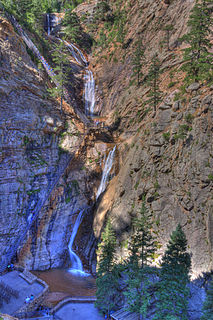
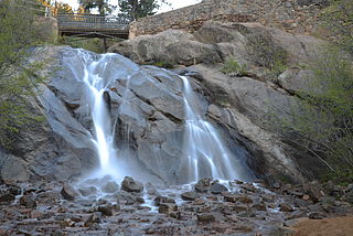
The Broadmoor Seven Falls is a series of seven cascading waterfalls of South Cheyenne Creek in South Cheyenne Cañon, Colorado Springs, Colorado. It is a privately owned tourist attraction since it was opened in the early 1880s. Trails from the top of the falls lead to Midnight Falls, near the headwaters of South Cheyenne Creek, and Inspiration Point. The area sustained a significant flood in September 2013, which had closed Seven Falls until restoration was complete late Summer 2015 by The Broadmoor. The resort bought Seven Falls after it had been owned and operated by families since the 1880s.

Midland Terminal Railway

The Midland Terminal Railway was a short line terminal railroad running from the Colorado Midland Railway near Divide to Cripple Creek, Colorado. The railroad made its last run in February 1949.

Old Colorado City Place in Colorado, United States

Old Colorado City, formerly Colorado City, was once a town, but it is now a neighborhood within the city of Colorado Springs, Colorado. Its commercial district was listed on the National Register of Historic Places in 1982. It was founded during the Pikes Peak Gold Rush of 1859 and was involved in the mining industry, both as a supply hub and as a gold ore processing center beginning in the 1890s. Residents of Colorado City worked at some of the 50 coal mines of the Colorado Springs area. It was briefly the capital of the Colorado Territory. For many years, Colorado Springs prohibited the use of alcohol within its border due to the lifestyle of Colorado City's opium dens, bordellos, and saloons. It is now a tourist area, with boutiques, art galleries, and restaurants.

History of Colorado Springs, Colorado Place in Colorado, United States

Before it was founded, the site of modern-day Colorado Springs, Colorado, was part of the American frontier. Old Colorado City, built in 1858 during the Pike's Peak Gold Rush was the Colorado Territory capital. The town of Colorado Springs, was founded by General William Jackson Palmer as a resort town. Old Colorado City was annexed into Colorado Springs. Railroads brought tourists and visitors to the area from other parts of the United States and abroad. The city was noted for junctions for seven railways: Denver and Rio Grande (1870), Denver and New Orleans Manitou Branch (1882), Colorado Midland (1886-1918), Colorado Springs and Interurban, Atchison, Topeka, and Santa Fe (1889), Rock Island (1889), and Colorado Springs and Cripple Creek Railways. It was also known for mining exchanges and brokers for the Cripple Creek Gold Rush.

Mineralogy of the Pikes Peak Region

The Pikes Peak region is renowned for its rare mineral specimens. It is a favorite collecting area for rock hounds and serious collectors alike. Scientists from around the world come to Colorado to study the minerals of this region. Because the granite covers a large portion of the Colorado Front Range, there are good mineral collecting areas scattered all over the Pikes Peak region. The collecting localities range from near Colorado Springs on the south to just west of Denver on the north.

Bear Creek Cañon Park

Bear Creek Cañon Park is a high-country park located in Colorado Springs, Colorado with steep trails for hiking, mountain biking and horseback riding.

North Cheyenne Cañon Park

North Cheyenne Cañon Park or North Cheyenne Canyon Park is a regional park located in Colorado Springs, Colorado. It is a National Register of Historic Places listing.

Parks in Colorado Springs, Colorado

There are a wide range of recreational areas and facilities in Colorado Springs, Colorado.

The Cripple Creek Gold Rush was a period of gold production in the Cripple Creek area from the late 1800s until the early 1900s. Mining exchanges were in Cripple Creek, Colorado Springs, Pueblo and Victor. Smelting was in Gillette, Florence, and (Old) Colorado City. Mining communities sprang up quickly, but most lasted only as long as gold continued to be produced. Settlements included:

Seven Lakes, Colorado human settlement in United States of America

Seven Lakes is an abandoned, historical populated place in Teller County, Colorado on the Pikes Peak mountain. It was once the site of the Seven Lakes Hotel along a carriage road to the summit of Pikes Peak. Its waters flow from Beaver Creek to the Lake Moraine reservoir, a supplier of water to Colorado Springs.

Golden Cycle Mining and Reduction Company

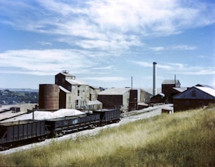
Golden Cycle Mining and Reduction Company was a mining company in Colorado City in El Paso County, Colorado. The company was incorporated in West Virginia and was listed on the Colorado Springs Exchange. Albert E. Carlton was part owner of the Golden Cycle. Directors included Carlton, Spencer Penrose, Richard Roelofs, H. McGarry, L.G. Carlton, Bulkeley Wells.

Cheyenne Mountain mountain

Cheyenne Mountain is a triple-peaked mountain in El Paso County, Colorado, southwest of downtown Colorado Springs. The mountain serves as a host for military, communications, recreational, and residential functions. The underground operations center for the North American Aerospace Defense Command (NORAD) was built during the Cold War to monitor North American airspace for missile launches and Soviet military aircraft. Built deep within granite, it was designed to withstand bombing and fallout from a nuclear bomb. Its function broadened with the end of the Cold War, and then many of its functions were transferred to Peterson Air Force Base in 2006.

In the mid-19th century, Colorado Springs was a center of mining industry activity. Coal was mined in 50 mines in the area and towns, now annexed to Colorado Springs, were established to support residents of the coal mining industry.

References

  1. 1 2 3 4 5 6 "St. Peter's Dome". The Gazette. Colorado Springs. January 12, 2010. Retrieved January 19, 2015.
  2. "St. Peter's Dome". trails.com. Retrieved January 19, 2015.
  3. 1 2 Tim Toula (1 November 2002). Rock 'n' Road: An Atlas of North American Rock Climbing Areas. Globe Pequot Press. p. 532. ISBN   978-0-7627-2306-5.
  4. Colorado Springs & Cripple Creek District Railway (1904). The Short Line Blue Book. Blue Book Publishing Company. pp. 18–.
  5. Colorado Promotion and Publicity Committee (1904). Colorado, Its Hotels and Resorts. Denver: Colorado Promotion and Publicity Committee. p. 27.
  6. Colorado Springs & Cripple Creek District Railway (1904). The Short Line Blue Book. Blue Book Publishing Company. pp. 18–.
  7. 1 2 3 "Cheyenne District (St. Peter's Dome District)". Western Mining History. Retrieved January 19, 2015.
  8. "On minerals of the cryolite group recently found in Colorado". American Journal of Science. Retrieved 2014-03-02.
  9. Charles Abiathar White (1885). On the Mesozoic and Cenozoic Paleontology of California. U.S. Government Printing Office. p. 259.

Coordinates: 38°44′50.4″N104°54′41.5″W / 38.747333°N 104.911528°W / 38.747333; -104.911528