
Lindisfarne, also known as Holy Island, is a tidal island off the northeast coast of England, which constitutes the civil parish of Holy Island in Northumberland. Holy Island has a recorded history from the 6th century AD; it was an important centre of Celtic Christianity under Saints Aidan, Cuthbert, Eadfrith, and Eadberht of Lindisfarne. The island was originally home to a monastery, which was destroyed during the Viking invasions but re-established as a priory following the Norman Conquest of England. Other notable sites built on the island are St Mary the Virgin parish church, Lindisfarne Castle, several lighthouses and other navigational markers, and a complex network of lime kilns. In the present day, the island is an Area of Outstanding Natural Beauty and a hotspot for historical tourism and bird watching. As of February 2020, the island had three pubs, a hotel and a post office as well as a museum with vast historical importance.

Northumbria was an early medieval Anglian kingdom in what is now Northern England and South Scotland.

Cuthbert of Lindisfarne was a saint of the early Northumbrian church in the Celtic tradition. He was a monk, bishop and hermit, associated with the monasteries of Melrose and Lindisfarne in the Kingdom of Northumbria, today in northern England and southern Scotland. Both during his life and after his death, he became a popular medieval saint of Northern England, with a cult centred on his tomb at Durham Cathedral. Cuthbert is regarded as the patron saint of Northumbria. His feast days are 20 March and 4 September.

Northumberland is a ceremonial county in North East England, bordering Scotland. It is bordered by the Scottish Borders to the north, the North Sea to the east, Tyne and Wear and County Durham to the south, and Cumbria to the west. The town of Blyth is the largest settlement. Northumberland is the northernmost county in England.

The Farne Islands are a group of islands off the coast of Northumberland, England. The group has between 15 and 20 islands depending on the level of the tide. They form an archipelago, divided into the Inner Group and the Outer Group. The main islands in the Inner Group are Inner Farne, Knoxes Reef, the East and West Wideopens, and the Megstone; the main islands in the Outer Group are Staple Island, Brownsman, North and South Wamses, Big Harcar, and Longstone. The two groups are separated by Staple Sound. The highest point on Inner Farne is 19 metres (62 ft) above mean sea level and on Staple Island is 14 metres (46 ft).

Norham is a village and civil parish in Northumberland, England. It is 7 miles (11 km) south-west of Berwick on the south side of the River Tweed where it is the border with Scotland.

Crayke is a village and civil parish in North Yorkshire, England, about 2 miles (3.2 km) east of Easingwold.

The County Palatine of Durham was a jurisdiction in the North of England, within which the bishop of Durham had rights usually exclusive to the monarch. It developed from the Liberty of Durham, which emerged in the Anglo-Saxon period. The gradual acquisition of powers by the bishops led to Durham being recognised as a palatinate by the late thirteenth century, one of several such counties in England during the Middle Ages. The county palatine had its own government and institutions, which broadly mirrored those of the monarch and included several judicial courts. From the sixteenth century the palatine rights of the bishops were gradually reduced, and were finally abolished in 1836. The last palatine institution to survive was the court of chancery, which was abolished in 1972.
What is usually referred to as St Cuthbert's coffin is a fragmentary oak coffin in Durham Cathedral, pieced together in the 20th century, which between AD 698 and 1827 contained the remains of Saint Cuthbert, who died in 687. In fact when Cuthbert's remains were yet again reburied in 1827 in a new coffin, some 6,000 pieces of up to four previous layers of coffin were left in the burial, and then finally removed in 1899. This coffin is thought to be Cuthbert's first wooden coffin, and probably to date to 698, when his remains were moved from a stone sarcophagus in the abbey church at Lindisfarne to the main altar.
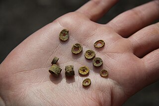
St. Cuthbert's beads are fossilised portions of the "stems" of crinoids from the Carboniferous period. Crinoids are a kind of marine echinoderm which are still extant, and which are sometimes known as "sea lilies". These bead-like fossils are washed out onto the beach and in medieval Northumberland were strung together as necklaces or rosaries, and became associated with St Cuthbert.

The Diocese of Hexham and Newcastle is a Latin Church diocese of the Catholic Church, centred on St Mary's Cathedral in the city of Newcastle upon Tyne in England. The diocese is one of the six suffragan sees in the ecclesiastical Province of Liverpool and covers the historic boundaries of County Durham and Northumberland.
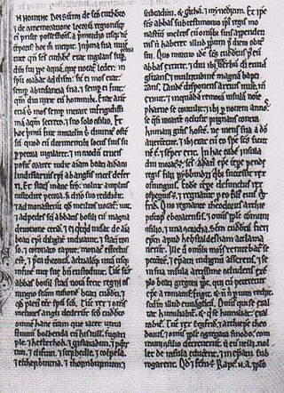
The Historia de Sancto Cuthberto is a historical compilation finished some time after 1031. It is an account of the history of the bishopric of St Cuthbert—based successively at Lindisfarne, Norham, Chester-le-Street and finally Durham—from the life of St Cuthbert himself onwards. The latest event documented is a grant by King Cnut, c. 1031. The work is a cartulary chronicle recording grants and losses of property as well as miracles of retribution, under a loose narrative of temporal progression. The text survives in three manuscripts, the earliest of which dates from around 1100. The original version of the text is not thought to be extant; rather, all surviving manuscripts are thought to be copies of an earlier but lost exemplar. The Historia is one of the sources for the histories produced at Durham in the early 12th century, particularly the Historia Regum and Symeon of Durham's Libellus de Exordio.
The Vita Sancti Cuthberti is a prose hagiography from early medieval Northumbria. It is probably the earliest extant saint's life from Anglo-Saxon England, and is an account of the life and miracles of Cuthbert, a Bernician hermit-monk who became bishop of Lindisfarne. Surviving in eight manuscripts from Continental Europe, it was not as well read in the Middle Ages as the prose version by Bede. It was however Bede's main source for his two dedicated works on Cuthbert, the "Metrical Life" and the "Prose Life".
Bertram Colgrave was a medieval historian, antiquarian and archaeologist, specializing on the lives of the early saints in Anglo-Saxon England.

St Cuthbert's Well, known locally as Cuddy's Well, is an ancient holy well in the village of Bellingham, adjacent to St Cuthbert's Church, an eleventh-century church associated with the cult of the seventh century monk, bishop and hermit St Cuthbert.
Rev. J W Dunn (1812-1883) was an Anglican vicar of Warkworth in Northumberland

The Northumberland Sandstone Hills are a major natural region in the English county of Northumberland. The hills form distinctive skylines with generally level tops, northwest facing scarps and craggy outcrops offering views to the Cheviots further west.
Alfred, son of Westou was a medieval English priest and relic collector, active in Northumberland. He is now best known for allegedly stealing the remains of Bede and bringing them in secret to the shrine of St Cuthbert in Durham, although some modern scholars consider this unlikely. He is also documented as having translated the remains of Boisil of Melrose Abbey, as well as numerous northern English minor saints of the 7th and 8th centuries: the anchorites Balther and Bilfrid; Acca, Alchmund and Eata, bishops of Hexham; Oswin, king of Deira; and the abbesses Ebba and Æthelgitha. He served as the sacristan at Cuthbert's shrine under three bishops, and was renowned for his devotion to the saint.
Thrunton Wood is an area of woodland and open moor in Northumberland. It is popular with walkers, mountain bikers and horse riders, and home to two waymarked walking trails. There is an Iron Age fort on Castle Hill, and Thrunton Wood is home to several caves, including Macartney's Cave, once home to a local monk, and Thomas Wedderburn's Hole, where a local highwayman reputedly once hid from the law.<ref>Scaife, Chris: The Caves of Northumberland, Sigma Leisure, 2019</ref

Northumbria, in modern contexts, usually refers to the region of England between the Tees and Tweed, including the historic counties of Northumberland and Durham, but it may also be taken to be synonymous with North East England. The area corresponds to the rump lands of the historical Kingdom of Northumbria, which later developed into the late medieval county of Northumberland or Comitatus Northumbriae, whose original southern boundary was the River Tees. A provincial flag of Northumbria has been registered.


