
Norwood is a suburb of Adelaide, about 4 km (2.5 mi) east of the Adelaide city centre. The suburb is in the City of Norwood Payneham & St Peters, whose predecessor was the oldest South Australian local government municipality.

Prospect is the seat of the City of Prospect and an inner northern suburb of greater Adelaide. It is located 5 km (3.1 mi) north of Adelaide's centre.
Glenside is a suburb in the local government area known as the City of Burnside, Adelaide, South Australia. The suburb is 4.9 kilometres south-east of the Adelaide city centre, home to 2,422 people in a total land area of 1.40 km2.

Enfield is a suburb in Adelaide, Australia. The suburb is about a 10-minute drive north from Adelaide city centre. The suburb is bordered by Gepps Cross to the north, Blair Athol to the west, Clearview to the east, and Prospect, Sefton Park and Broadview to the south.

Kilburn is a suburb in the inner north of Adelaide, South Australia. The suburb borders Blair Athol, Gepps Cross, Wingfield, Regency Park and Prospect. Kilburn has the same postcode (5084) as Blair Athol.

Torrensville is a western suburb 3 km (1.9 mi) west of the centre of Adelaide, South Australia. It was named after Irish-born economist and chairman of the South Australian Colonisation Commission, Robert Torrens.
West Croydon is an inner western suburb of Adelaide, South Australia.

Parkside is an inner southern suburb of Adelaide, South Australia. It is located in the City of Unley.

Hackney is an inner-eastern suburb of Adelaide, South Australia, in the City of Norwood Payneham St Peters. It is adjacent to the Adelaide Park Lands, the Adelaide city centre and North Adelaide. The O-Bahn Busway passes along Hackney Road, part of the City Ring Route, which forms its western boundary. Its other boundaries are the River Torrens (north), the continuation of North Terrace through Kent Town (south), and a series of small streets and lanes to the east.
Kensington is a suburb of Adelaide, South Australia in the City of Norwood, Payneham & St Peters council area. Unlike the rest of the city, Kensington's streets are laid out diagonally. Second Creek runs through and under part of the suburb, which contains many heritage buildings as well as Norwood Swimming Centre and several schools.

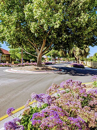
Thebarton, formerly Theberton, on Kaurna land, is an inner-western suburb of Adelaide, South Australia in the City of West Torrens. The suburb is bounded by the River Torrens to the north, Port Road and Bonython Park to the east, Kintore Street to the south, and South Road to the west.

Park Holme is a south-western suburb of Adelaide in the City of Marion, South Australia, located about 8 km (5 mi) from the Adelaide city centre. It is bordered to the east by Marion Road, to the west by Hendrie Street, to the south by Oaklands Road, and to the north by Tarranna Ave, which is just south of Bray Street. It is adjacent to Ascot Park, Edwardstown, South Plympton, Mitchell Park, Clovelly Park, Glengowrie, Morphettville and Oaklands Park. Park Holme covers 115 hectares, (1.15 sq km).
The City of West Torrens is a local government area in the western suburbs of Adelaide, South Australia. Since the 1970s, the area was mainly home to many open spaces and parks, however after the mid-1990s (1993–1995) the LGA became more residential.

Croydon Park is a north-western suburb of Adelaide 5.9 km from the CBD, in the state of South Australia, Australia and is within the City of Port Adelaide Enfield. It is adjacent to Dudley Park, Devon Park, Renown Park, Regency Park, Ferryden Park Kilkenny, and West Croydon. The post code for Croydon Park is 5008. It is bounded to the south by Lamont Street and Torrens Road, to the north by Regency Road and in the east and west by Harrison Road and Goodall Avenue respectively. Croydon Park is predominantly a residential suburb, with a warehousing presence on the northern edges near Regency Road. Croydon Park has been completely divided by the North-South Motorway.

Brompton is an inner-northern suburb of Adelaide, South Australia in the City of Charles Sturt.
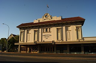
The Thebarton Theatre, also known as the Thebbie Theatre or simply Thebbie/Thebby, is an entertainment venue located in the inner-western Adelaide suburb of Torrensville, South Australia. Built in 1926 as a combined town hall / picture theatre and officially known as Thebarton Town Hall and Municipal Offices, the building was opened in June 1928. It was listed on the South Australian Heritage Register on 23 September 1982.

The Greek Orthodox Church of St. George is a church in the suburb of Mile End, in the South Australian capital of Adelaide. It is under the auspices of the Greek Orthodox Archdiocese of Australia and spiritual direction of Archbishop Makarios of Australia and is the largest Greek Orthodox church in Adelaide. This is partly due to the high population of Greek Australians in the area, mostly from Thebarton, Torrensville and Mile End.

Mile End is an inner western suburb of Adelaide, located in the City of West Torrens, around 2 kilometres from the Adelaide city centre. It has a census area population of 4,413 people (2011). Much of the suburb is residential, but there are small commercial areas along Henley Beach Road and South Road.

Charlotte Street is a road in the central business district of Brisbane, Queensland, Australia. The street is one of a number that were named after female queens and princesses of the royal family shortly after the penal colony was settled. Mary Street runs parallel to the south and Elizabeth Street is the next street to the north.

Grenfell Centre, formerly known as Oracle House and JLW Building, nicknamed Black Stump, is a high rise office building located at 25 Grenfell Street in the Adelaide city centre, South Australia.
