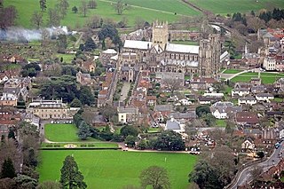
Wells is a cathedral city and civil parish in the Mendip district of Somerset, on the southern edge of the Mendip Hills. Although the population recorded in the 2011 census was only 10,536, and with a built-up area of just 3.244 square kilometres, Wells has had city status since medieval times, because of the presence of Wells Cathedral. Often described as England's smallest city, it is actually second smallest to the City of London in area and population, but unlike London it is not part of a larger urban agglomeration.

Woodspring Priory is a former Augustinian priory. It is near the scenic limestone promontory of Sand Point and Middle Hope, owned by the National Trust, beside the Severn Estuary about 3 miles (5 km) north-east of Weston-super-Mare, within the English unitary authority of North Somerset. Many of the buildings are Grade I listed, and the whole site is scheduled as an ancient monument.
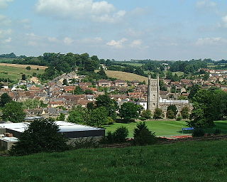
Bruton is a town, electoral ward, and civil parish in Somerset, England, on the River Brue and on the A359 between Frome and Yeovil. It is 7 miles (11 km) south-east of Shepton Mallet, just south of Snakelake Hill and Coombe Hill, 10 miles (16 km) north-west of Gillingham and 12 miles (19 km) south-west of Frome in South Somerset district. The town and ward have a population of 2,907. The parish includes the hamlets of Wyke Champflower and Redlynch. Bruton has a museum of items from its past from the Jurassic onwards. It includes a table used by the author John Steinbeck on a six-month stay. The River Brue has a history of flooding. In 1768 it destroyed a stone bridge. On 28 June 1917, 242.8 mm of rain fell in 24 hours, leaving a watermark on a pub 20 feet above mean level. In 1984 a protective dam was built 1 km upstream.

Witham Friary is a small English village and civil parish located between the towns of Frome and Bruton in the county of Somerset. It is in the Cranborne Chase and West Wiltshire Downs Area of Outstanding Natural Beauty and the ancient Forest of Selwood.
West Harptree is a small village and civil parish in the Chew Valley, Somerset within the unitary district of Bath and North East Somerset. The parish has a population of 439.
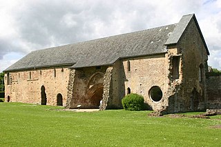
Cleeve Abbey is a medieval monastery located near the village of Washford, in Somerset, England. It is a Grade I listed building and has been scheduled as an ancient monument.

Yarlington is a village and civil parish, near the source of the River Cam, in the English county of Somerset.

Stoke sub Hamdon Priory is a complex of buildings and ruins which initially formed a 14th-century college for the chantry chapel of St Nicholas, and later was the site of a farm in Stoke-sub-Hamdon, Somerset, England. The only building remaining from the college is a great hall and attached dwelling, dating from the late 15th century. The hall is designated by English Heritage as a Grade I listed building, while the outbuildings and gateway are Grade II listed. The whole site has been scheduled as an ancient monument. A number of the farm buildings are in poor condition, and have been added to the Heritage at Risk Register.

Cannington is a village and civil parish 3 miles (5 km) northwest of Bridgwater in the Sedgemoor district of Somerset, England. It lies on the west bank of the River Parret, and contains the hamlet of Edstock.

Bath and North East Somerset is a unitary authority created on 1 April 1996, following the abolition of the County of Avon, which had existed since 1974. Part of the ceremonial county of Somerset, Bath and North East Somerset occupies an area of 220 square miles (570 km2), two-thirds of which is green belt. It stretches from the outskirts of Bristol, south into the Mendip Hills and east to the southern Cotswold Hills and Wiltshire border. The city of Bath is the principal settlement in the district, but BANES also covers Keynsham, Midsomer Norton, Radstock and the Chew Valley. The area has a population of 170,000, about half of whom live in Bath, making it 12 times more densely populated than the rest of the area.
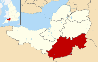
South Somerset is a local government district in the English county of Somerset. The South Somerset district occupies an area of 370 square miles (958 km2), stretching from its borders with Devon and Dorset to the edge of the Somerset Levels. The district has a population of about 158,000, and has Yeovil as its administrative centre.

Vicars' Close, in Wells, Somerset, England, is claimed to be the oldest purely residential street with original buildings surviving intact in Europe. John Julius Norwich called it "that rarest of survivals, a planned street of the mid-14th century". It comprises numerous Grade I listed buildings, comprising 27 residences, built for Bishop Ralph of Shrewsbury, a chapel and library at the north end, and a hall at the south end, over an arched gate. It is connected at its southern end to the cathedral by way of a walkway over Chain Gate.
South Somerset is a local government district in the English county of Somerset. The South Somerset district occupies an area of 370 square miles (958 km2), stretching from its borders with Devon and Dorset to the edge of the Somerset Levels. The district has a population of about 158,000, and has Yeovil as its administrative centre.

Sand Point in Somerset, England, is the peninsula stretching out from Middle Hope, an 84.1-hectare (208-acre) biological and geological Site of Special Scientific Interest. It lies to the north of the village of Kewstoke, and the stretch of coastline called Sand Bay north of the town of Weston-super-Mare. On a clear day it commands views over Flat Holm, of the Bristol Channel, South Wales, Clevedon, the Second Severn Crossing and the Severn Bridge. A line drawn between Sand Point and Lavernock Point in South Wales marks the lower limit of the Severn Estuary and the start of the Bristol Channel.

The Dovecot At Blackford Farm in Selworthy on Exmoor within the English county of Somerset was probably built in the 11th century. It is a Grade II* listed building, and scheduled monument.

Taunton Deane was a local government district with borough status in Somerset, England. It merged with West Somerset to form Somerset West and Taunton on 1 April 2019. Its council was based in Taunton. The district was formed on 1 April 1974, under the Local Government Act 1972, by a merger of the Municipal Borough of Taunton, Wellington Urban District, Taunton Rural District, and Wellington Rural District. Taunton Deane was granted borough status in 1975, enabling the mayoralty of Taunton to be continued, when other districts did not have mayors. The district was given the name of an alternate form of the Taunton Deane Hundred.

There are over 670 scheduled monuments in the ceremonial county of Somerset in South West England. The county consists of a non-metropolitan county, administered by Somerset County Council, which is divided into five districts, and two unitary authorities. The districts of Somerset are West Somerset, South Somerset, Taunton Deane, Mendip and Sedgemoor. The two administratively independent unitary authorities, which were established on 1 April 1996 following the breakup of the county of Avon, are North Somerset and Bath and North East Somerset. These unitary authorities include areas that were once part of Somerset before the creation of Avon in 1974.
King Square in Bridgwater within the English county of Somerset was laid out with large Georgian houses between 1770 and 1800 on the site of Bridgwater Castle. It is also the site of the Bridgwater War Memorial

