St Mary's (Chepstow ward)

Last updated

St Mary's
Electoral ward
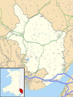
Monmouthshire UK location map.svg
Red pog.svg
St Mary's
Location within Monmouthshire
Population1,847 (2011 census)
Community
Principal area
Country Wales
Sovereign state United Kingdom
EU Parliament Wales
UK Parliament
Welsh Assembly
Councillors1 (County), 3 (Town)
List of places
UK
Wales
Monmouthshire
51°38′28″N2°40′19″W / 51.641°N 2.672°W / 51.641; -2.672 Coordinates: 51°38′28″N2°40′19″W / 51.641°N 2.672°W / 51.641; -2.672

St Mary's is the name of an electoral ward in the town of Chepstow, Monmouthshire, Wales. The ward elects councillors to Chepstow Town Council and Monmouthshire County Council.
Chepstow town in Wales

Chepstow is a town and community in Monmouthshire, Wales, adjoining the border with Gloucestershire, England. It is located on the River Wye, about 2 miles (3.2 km) above its confluence with the River Severn, and adjoining the western end of the Severn Bridge. It is 16 miles (26 km) east of Newport, 28 miles (45 km) east-northeast of Cardiff, 18 miles (29 km) northwest of Bristol and 110 miles (180 km) west of London.

Monmouthshire County

Monmouthshire is a county in south-east Wales. The name derives from the historic county of Monmouthshire of which it covers the eastern 60%. The largest town is Abergavenny. Other towns and large villages are Caldicot, Chepstow, Monmouth, Magor and Usk. It borders Torfaen and Newport to the west; Herefordshire and Gloucestershire to the east; and Powys to the north.

Wales Country in northwest Europe, part of the United Kingdom

Wales is a country that is part of the United Kingdom. It is bordered by England to the east, the Irish Sea to the north and west, and the Bristol Channel to the south. It had a population in 2011 of 3,063,456 and has a total area of 20,779 km2 (8,023 sq mi). Wales has over 1,680 miles (2,700 km) of coastline and is largely mountainous with its higher peaks in the north and central areas, including Snowdon, its highest summit. The country lies within the north temperate zone and has a changeable, maritime climate.

Contents

Description

The St Mary's ward covers the town centre of the Chepstow, which includes the Priory parish church of the same name. The ward is bordered to the north and east by the River Wye (and the England border). To the west is Chepstow's St Kingsmark ward and to the south are the Chepstow wards of Larkfield and St Christopher's. [1]

Priory Church of St Mary, Chepstow Church in Wales

The Parish and Priory Church of St. Mary is located in Chepstow, Monmouthshire, south east Wales. Parts of the building, including its ornate west doorway, date from the late 11th century and are contemporary with the nearby Norman castle. The church is a Grade I listed building as of 6 December 1950.

River Wye river in Wales and England

The River Wye is the fifth-longest river in the UK, stretching some 215 kilometres from its source on Plynlimon in mid Wales to the Severn estuary. For much of its length the river forms part of the border between England and Wales. The Wye Valley is an Area of Outstanding Natural Beauty. The Wye is important for nature conservation and recreation.

England Country in north-west Europe, part of the United Kingdom

England is a country that is part of the United Kingdom. It shares land borders with Wales to the west and Scotland to the north. The Irish Sea lies west of England and the Celtic Sea to the southwest. England is separated from continental Europe by the North Sea to the east and the English Channel to the south. The country covers five-eighths of the island of Great Britain, which lies in the North Atlantic, and includes over 100 smaller islands, such as the Isles of Scilly and the Isle of Wight.

According to the 2001 UK Census the population of the St Mary's ward was 1,741, rising to 1,847 by 2011. [2]

Town Council elections

St Mary's is a community ward for elections to Chepstow Town Council. The St Mary's ward elects or co-opts three town councillors to the town council. [3]

County Council elections

St Mary's is a county electoral ward for elections to Monmouthshire County Council, represented by one county councillor. [4] At the 1995 and 1999 elections the ward elected a Labour Party councillor. The 2004 and 2008 elections were won by the Liberal Democrats, though Labour's Peter Farley won the following 2012 election. [5] At the May 2017 elections Jez Becker won the seat back for the Liberal Democrats. [6]

Monmouthshire County Council

Monmouthshire County Council is the governing body for the Monmouthshire principal area – one of the unitary authorities of Wales.

Liberal Democrats (UK) Political party in the United Kingdom

The Liberal Democrats are a liberal political party in the United Kingdom. Currently led by Jo Swinson, the party has 19 Members of Parliament in the House of Commons, 96 members of the House of Lords, 16 members of the European Parliament, five Members of the Scottish Parliament and one member in each of the Welsh Assembly and the London Assembly. It was in a coalition government with the Conservative Party from 2010 to 2015.

2017 Monmouthshire County Council election [7]
PartyCandidateVotes%±
Liberal Democrat Jeremy Becker244
Conservative Marc Le Peltier214
Labour Dale Rooke176

Related Research Articles

Trowbridge, Cardiff human settlement in United Kingdom

Trowbridge is a district, community and coterminous electoral ward on the eastern edge of the city of Cardiff, capital of Wales.

The 2004 Monmouthshire County Council election were held on 10 June 2004 to Monmouthshire County Council in southeast Wales, on the same day of the European Elections.

Wyesham village in United Kingdom

Wyesham is a village and electoral ward in Monmouthshire, Wales. It is located less than one mile east of Monmouth, on the opposite side of the River Wye.

Trellech United community in Monmouthshire, south-east Wales

Trellech United is a community and electoral ward in the county of Monmouthshire, Wales. It lies south of the county town of Monmouth next to the Wales-England border.

Carmarthen Town South is an electoral ward, representing part of the community of Carmarthen, Carmarthenshire, Wales. Much of its southern border is defined by the River Towy, with the Carmarthen Town North and Carmarthen Town West wards to the north.

2017 Welsh local elections

Local elections were held in Wales on Thursday 4 May 2017 to elect members of all 22 local authorities, including the Isle of Anglesey, which was last up for election in 2013 due to having its elections delayed for a year. These local elections were held alongside local elections in Scotland and parts of England.

2017 Monmouthshire County Council election Election to all seats of the non-metropolitan county council of Monmouthshire in May 2012.

An election to Monmouthshire County Council took place on 4 May 2017 as part of the 2017 local elections across the United Kingdom. 43 councillors were to be elected from both single-member and dual-member electoral divisions by first-past-the-post for a four-year term of office.

Grangetown (Cardiff electoral ward) electoral division of the unitary authority of Cardiff

Grangetown is an electoral ward in the city of Cardiff, Wales. It covers its namesake community of Grangetown. The ward was originally created in 1890 as a ward to Cardiff County Borough Council.

Marl (Conwy electoral ward)

Marl is the name of one of the electoral wards in the community of Conwy, Conwy County Borough, Wales. It elects representatives to Conwy County Borough Council and Conwy Town Council. The Marl ward covers part of the town of Llandudno Junction to the east of the River Conwy and is one of four county wards included within the boundaries of the community. The wards of Deganwy and Pensarn border Marl, also to the east of the river. Conwy ward lies on the opposite side of the river, including the walled town of Conwy. To the north of Marl is the Llandudno ward of Penrhyn.

Pentwyn (electoral ward) electoral division of the unitary authority of Cardiff

Pentwyn is the name of an electoral ward in the northeast of Cardiff, capital city of Wales. It covers the communities of Pentwyn and Llanedeyrn. The ward has elected councillors to the post-1996 Cardiff Council and the pre-1996 Cardiff City Council.

St Mary (Brecon electoral ward)

St Mary is the name of an electoral ward in the town of Brecon, Powys, Wales. It covers the town centre and elects councillors to Brecon Town Council and Powys County Council.

Town, Merthyr Tydfil community in Merthyr Tydfil, Wales

Town is the name of a local government community and electoral ward in the town of Merthyr Tydfil, in Merthyr Tydfil County Borough, Wales.

Priory (Abergavenny ward) electoral ward in Abergavenny, Monmouthshire, Wales

Priory is an electoral ward in Abergavenny, Monmouthshire. The ward elects councillors to Abergavenny Town Council and Monmouthshire County Council.

Larkfield (electoral ward)

Larkfield is an electoral ward in Chepstow, Monmouthshire. The ward elects councillors to Chepstow Town Council and Monmouthshire County Council.

Drybridge (Monmouth ward)

Drybridge is an electoral ward in the town of Monmouth, Monmouthshire, Wales. The ward elects councillors to Monmouth Town Council and Monmouthshire County Council.

Caldicot Castle (electoral ward)

Caldicot Castle is an electoral ward in the town of Caldicot, Monmouthshire, Wales. The ward elects councillors to Caldicot Town Council and Monmouthshire County Council.

Severn (Caldicot ward)

Severn is the name of an electoral ward in the town of Caldicot, Monmouthshire, Wales. The ward elects councillors to Caldicot Town Council and Monmouthshire County Council.

West End (Caldicot ward)

West End is an electoral ward in the town of Caldicot, Monmouthshire, Wales. The ward elects councillors to Caldicot Town Council and Monmouthshire County Council.

Heath (electoral ward)

Heath is the name of an electoral ward in the north of the city of Cardiff, Wales, which covers its namesake community, Heath. The ward elects three county councillors to the County Council of the City and County of Cardiff.

References

  1. "Election maps". Ordnance Survey . Retrieved 13 January 2019.
  2. "St. Mary's - Ward in Wales". City Population. Retrieved 13 January 2019.
  3. "Contact the Council". Chepstow Town Council. Retrieved 13 January 2019.
  4. The County of Monmouthshire (Electoral Changes) Order 2002. legislation.gov.uk. Statutory Instruments. 6 December 2002. Retrieved 13 January 2019.
  5. "Monmouthshire County Council Election Results 1995-2012" (PDF). The Elections Centre. Retrieved 13 January 2019.
  6. "Caldicot councillor to serve as Monmouthshire chairman". Monmouthshire Beacon. 11 May 2016. Retrieved 13 January 2019.
  7. "Council elections 2017: Conservatives claim Monmouthshire". Monmouthshire Beacon. 4 May 2017. Retrieved 13 January 2019.