
King's Cross is a district in the London Boroughs of Camden and Islington, it’s on either side of Euston Road, in the outskirts of north London and central London, England, 1.5 miles (2.4 km) north of Charing Cross. It is bordered by Barnsbury to the north, Clerkenwell to the southeast, Angel to the east, Holborn and Bloomsbury to the south, Euston to the west and Camden Town to the northwest. It is served by two major rail termini, St Pancras and King's Cross. King's Cross station is the terminus of one of the major rail routes between London and the North.

The Tay Bridge carries rail traffic across the Firth of Tay in Scotland between Dundee and the suburb of Wormit in Fife. Its span is 2.75 miles. It is the second bridge to occupy the site.

Castlefield is an inner-city conservation area in Manchester, North West England. The conservation area which bears its name is bounded by the River Irwell, Quay Street, Deansgate and Chester Road. It was the site of the Roman era fort of Mamucium or Mancunium which gave its name to Manchester. It was the terminus of the Bridgewater Canal, the world's first industrial canal, built in 1764; the oldest canal warehouse opened in 1779. The world's first passenger railway terminated here in 1830, at Liverpool Road railway station and the first railway warehouse opened here in 1831.
The Nickey line is a disused railway that once linked the towns of Hemel Hempstead and, initially, Luton but later Harpenden via Redbourn, in Hertfordshire, England. The course of most of the railway has been redeveloped as a cycle and walking path, and is part of the Oxford to Welwyn Garden City route of the National Cycle Network. It is approximately nine miles (14 km) long.

A gas holder or gasholder, also known as a gasometer, is a large container in which natural gas or town gas is stored near atmospheric pressure at ambient temperatures. The volume of the container follows the quantity of stored gas, with pressure coming from the weight of a movable cap. Typical volumes for large gas holders are about 50,000 cubic metres (1,800,000 cu ft), with 60-metre-diameter (200 ft) structures.

A gasworks or gas house is an industrial plant for the production of flammable gas. Many of these have been made redundant in the developed world by the use of natural gas, though they are still used for storage space.

Appleby is a railway station on the Settle and Carlisle Line, which runs between Carlisle and Leeds via Settle. The station, situated 30 miles 60 chains (49.5 km) south-east of Carlisle, serves the market town of Appleby-in-Westmorland, Eden in Cumbria. It is owned by Network Rail and managed by Northern Trains.
William Fairbairn and Sons, was an engineering works in Manchester, England.
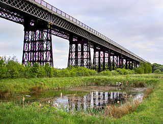
Bennerley Viaduct is a former railway bridge, now a foot and cycle bridge, between Ilkeston, Derbyshire, and Awsworth, Nottinghamshire, in central England. It was completed in 1877 and carried the Great Northern Railway's (GNR) Derbyshire Extension over the River Erewash, which forms the county boundary, and its wide, flat valley. The engineer was Samuel Abbott, who worked under Richard Johnson, the GNR's chief engineer. The site required a bespoke design as the ground would not support a traditional masonry viaduct due to extensive coal mining. The viaduct consists of 16 spans of wrought iron, lattice truss girders, carried on 15 wrought iron piers which are not fixed to the ground but are supported by brick and ashlar bases. The viaduct is 60 feet high, 26 feet wide between the parapets, and over a quarter of a mile long. It was once part of a chain of bridges and embankments carrying the railway for around two miles across the valley but most of its supporting structures were demolished when the line closed in 1968. The only similar surviving bridge in the United Kingdom is Meldon Viaduct in Devon.
The North British, Arbroath and Montrose Railway was a company established by Act of Parliament in 1871 to construct and operate a railway line from north of Arbroath via Montrose to Kinnaber Junction, 38 miles (61 km) south of Aberdeen. The company was originally a subsidiary of the North British Railway but was absorbed into its parent in 1880.

A balloon flange girder or (colloquially) balloon topper is a form of vertical I-beam wrought iron plate girder, where the top flange, instead of being a simple flat plate, is extended into a hollow tube. When a girder is subjected to a positive bending moment the top flange acts in compression making a flat plate flange more susceptible to local buckling than the balloon flange is.

The Oval Gasholders is the unofficial name given to the gas holder (gasometer) located near The Oval cricket stadium in London, England. Construction began in 1853 and the site is officially called Kennington Holder Station by its owners, Southern Gas Network. It is a grade II listed building with the listed part of them known as Gasholder No. 1.

Newstead Gasworks is a heritage-listed former gasometer at 70 Longland Street, Teneriffe, City of Brisbane, Queensland, Australia. It was built from 1873 to 1887. It is also known as Brisbane Gas Company Gasworks and Newstead Gasworks No.2 gasholder. It was added to the Queensland Heritage Register on 24 June 2005.
West End Gasworks is a heritage-listed gasworks at 321 Montague Road, West End, Queensland, Australia. It is also known as South Brisbane Gas and Light Company Works. It was added to the Queensland Heritage Register on 22 October 1999.

The Macdonald River railway bridge is a heritage-listed railway bridge that carries the Main Northern Line across the Macdonald River located in Woolbrook, in the Walcha Shire, New South Wales, Australia. The railway bridge was designed by John Whitton as the Engineer-in-Chief for the New South Wales Government Railways and built during 1882 by J. S. Bennett, with iron work by J. & C. Brettell, Worcester, England. The railway bridge is also known as the Woolbrook rail bridge over the Macdonald River and the Woolbrook Lattice Railway Bridge. The bridge and adjacent infrastructure is owned by Transport Asset Holding Entity, an agency of the Government of New South Wales. The bridge was added to the New South Wales State Heritage Register on 2 April 1999 and was added to the Register of the National Estate on 18 April 1989.
The Peel River railway bridge is a heritage-listed railway bridge that carries the Main North line across the Peel River connecting North Tamworth to Tambinda, both in the Tamworth Regional Council local government area of New South Wales, Australia. The railway bridge was designed by John Whitton as the Engineer-in-Chief for Railways and built during 1882 by J. S. Bennett, with iron work by J. & C. Brettell, Worcester, England. The bridge is also known as the Tamworth rail bridge over Peel River and the Tamworth Lattice Railway Bridge. The property is owned by Transport Asset Holding Entity, an agency of the Government of New South Wales. The bridge was added to the New South Wales State Heritage Register on 2 April 1999 and was added to the Register of the National Estate on 18 April 1989.

The Cooks River Sewage Aqueduct is a heritage-listed sewage aqueduct located at Pine Street, Earlwood, New South Wales, Australia. It crosses the Cooks River to Thornley Street, Marrickville. It was designed by Sewerage Construction Branch and NSW Department of Public Works and built during 1895 by J. F. Carson, contractor. The property is owned by Sydney Water, an agency of the Government of New South Wales. It was added to the New South Wales State Heritage Register on 18 November 1999.

The Wolli Creek Aqueduct is a heritage-listed sewage aqueduct located at Unwin Street, Earlwood, City of Canterbury-Bankstown, New South Wales, Australia.

The Bromley-by-Bow gasholders are a group of seven cast iron Victorian gasholders in Twelvetrees Crescent, West Ham and named after nearby Bromley in the London Borough of Tower Hamlets.

The Windsor Street Gasworks was a coal gas and coke manufacturing site in Nechells, Birmingham. The works were constructed in 1846 for the Birmingham Gas Light and Coke Company adjacent to the Birmingham and Fazeley Canal to allow for the bulk import of coal. The company was taken over by the Birmingham Corporation in 1875 and under mayor Joseph Chamberlain and engineer Charles Hunt the Windsor Street site was expanded and connected to the London and North Western Railway. Hunt's works included the construction, in 1885, of gasholders No. 13 and No.14, the largest in the world at that time, as well as modernisation of production.
