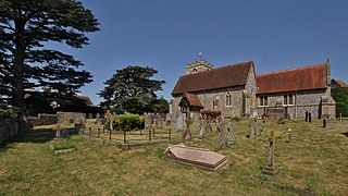
Shiplake consists of three settlements: Shiplake, Shiplake Cross and Lower Shiplake. Together these villages form a civil parish situated beside the River Thames 2 miles (3 km) south of Henley-on-Thames, Oxfordshire, England. The river forms the parish boundary to the east and south, and also the county boundary between Oxfordshire and Berkshire. The villages have two discrete centres separated by agricultural land. The 2011 Census records the parish population as 1,954 and containing 679 homes. The A4155 main road linking Henley with Reading, Berkshire passes through the parish.

Nettlebed is a village and civil parish in Oxfordshire in the Chiltern Hills about 4+1⁄2 miles (7 km) northwest of Henley-on-Thames and 6 miles (10 km) southeast of Wallingford. The parish includes the hamlet of Crocker End, about 1⁄2 mile (800 m) east of the village. The 2011 Census recorded a parish population of 727.

Watlington is a small market town and civil parish about 7 miles (11 km) south of Thame in Oxfordshire, near the county's eastern edge and less than 2 miles (3 km) from its border with Buckinghamshire. The parish includes the hamlets of Christmas Common, Greenfield and Howe Hill, all of which are in the Chiltern Hills. The 2011 Census recorded the parish's population as 2,727.

Bucknell is a village and civil parish 2+1⁄2 miles (4 km) northwest of Bicester in Oxfordshire, England. The 2011 Census recorded the parish's population as 260.

Wissett is a village and civil parish in the English county of Suffolk. It is 2 miles (3.2 km) north-east of the market town of Halesworth in the East Suffolk district. Historically, it was in the Blything Hundred.

Hilmarton is a village and civil parish in North Wiltshire, in the west of England. The village lies on the A3102 between the towns of Calne and Wootton Bassett, and 2 miles (3.2 km) south of Lyneham. The parish includes the village of Goatacre and the hamlets of Catcomb, Clevancy, Highway and New Zealand.

Brome is a village and former civil parish in the Mid Suffolk district, in the north of the English county of Suffolk. It lies on the A140 Norwich to Ipswich road around 1 mile (1.6 km) northwest of Eye and 2 miles (3.2 km) southeast of Diss near the border with Norfolk. In 1961 the parish had a population of 230. The village is now in the parish of Brome and Oakley and has been combined with the village of Oakley for centuries but the civil parish was only combined on 1 April 1982.

Church Hanborough is a village in Hanborough civil parish about 5 miles (8 km) northeast of Witney in Oxfordshire.

Henley is a village and civil parish in the Mid Suffolk district of Suffolk in eastern England located just north of the town Ipswich in Suffolk, England.

Shellingford, historically also spelt Shillingford, is a village and civil parish about 2+1⁄2 miles (4 km) south-east of Faringdon in the Vale of White Horse in Oxfordshire, England. It was part of Berkshire until the 1974 Local Government Act transferred it to Oxfordshire. The 2011 Census recorded the parish's population as 173.

Great Haseley is a village and civil parish in South Oxfordshire, England. The village is about 4.5 miles (7 km) southwest of Thame. The parish includes the hamlets of Latchford, Little Haseley and North Weston and the house, chapel and park of Rycote. The parish stretches 6 miles (10 km) along a northeast — southwest axis, bounded by the River Thame in the north, Haseley Brook in the south and partly by a boundary hedge with Little Milton parish in the west. The 2011 Census recorded a parish population of 511.

Taynton is a village and civil parish about 1+1⁄2 miles (2.4 km) northwest of Burford in West Oxfordshire. The village is on Coombe Brook, a tributary of the River Windrush. The parish is bounded in the south by the River Windrush, in the north partly by Coombe Brook and its tributary Hazelden Brook, in the west by the county boundary with Gloucestershire and in the east by field boundaries. The 2001 Census recorded the parish's population as 108.

Ufford is a village and civil parish in Suffolk, England. Its population of 808 at the 2001 census rose to 948 at the 2011 Census and was estimated at 1,008 in 2019. The village lies 2 miles south-south-west of Wickham Market and 13 miles north-east of Ipswich. The main road through the village was renumbered B1438 after its replacement as a trunk road by the new A12.

St Peter's Church is a redundant Anglican church in the village of Hockwold cum Wilton in Norfolk, England. It is recorded in the National Heritage List for England as a designated Grade I listed building, and is under the care of the Churches Conservation Trust.

St Mary and St Peter's Church is an active Anglican parish church in the village of Barham near Ipswich. It contains a Henry Moore statue of Madonna and the Child originally held at St Peter, Claydon. It is in the deanery of Bosmere, part of the archdeaconry of Ipswich, and the Diocese of St Edmundsbury and Ipswich.
All Saints' Church is located in the village of Ashbocking near Ipswich. It is an active Anglican parish church in the deanery of Woodbridge, part of the archdeaconry of Ipswich, and the Diocese of St Edmundsbury and Ipswich.

All Saints Church is located in the village of Acton near Sudbury. It is an Anglican parish church in the deanery of Sudbury, part of the archdeaconry of Ipswich, and the Diocese of St Edmundsbury and Ipswich.

St Martin's Church is located in the village of Nacton near Ipswich. It is an active Anglican parish church in the deanery of Colneys, part of the archdeaconry of Norfolk, and the Diocese of St Edmundsbury and Ipswich.

The Church of St Michael and All Angels is a Church of England parish church in Cookley, Suffolk. The church is a grade I listed building.

The Church of St Mary the Virgin is a Church of England parish church in Mendlesham, Suffolk. The church is a grade I listed building.

