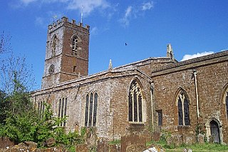
History
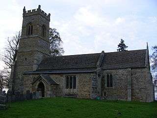
It is a Grade II* listed building and stands on the east side of Church Lane, to the north-east of the village of Harrington.
There is no reference to a church or priest in the entry for the parish in the Domesday Book, which was compiled in 1086. [1] This may indicate the absence of a church building at that stage or, alternatively, only the absence of a resident priest.
The main structure of the present building was erected in the 14th and 15th centuries. Its tower was built in 1809. The church consists of a nave, north and south aisles, north transept, chancel, south porch and south tower. A detailed description appears on the Historic England website [2]
The church displays a tuba stentoro-phonica, or a speaking trumpet, one of only eight in the country. Sir Samuel Morland claimed to have invented these horns, for speaking between ships. The device, also known as "The Harrington Vamping Horn", was demonstrated to Charles II in St James' Park. [3] In 1817, the Earl of Dysart gave to the church a ring of six bells, which were cast in the Whitechapel Bell Foundry.
The parish registers survive from 1673 and, apart from those currently in use, are kept at Northamptonshire Record Office. [4] Details of its location and opening times can be found on the Record Office website. [5]
Harrington is part of a united Benefice along with Arthingworth, East Farndon, and Oxendon. Each parish retains its own church building. [6]
The ecologist Adrian Woodruffe-Peacock was curate here from 1886 to 1890. [7]

Barby is a village and civil parish about 5 miles (8 km) north of Daventry in Northamptonshire, England. The 2011 Census recorded the parish population as 2,336. Barby is located right off the M45 motorway a short spur from the M1 motorway to the A45 Trunk Road.

Steeple Aston is a village and civil parish on the edge of the Cherwell Valley, in the Cherwell District of Oxfordshire, England, about 12 miles (19 km) north of Oxford, 7 miles (11 km) west of Bicester, and 10 miles (16 km) south of Banbury. The 2011 Census recorded the parish population as 947. The village is 108 metres (354 ft) above sea level. The River Cherwell and Oxford Canal pass 1 mile (2 km) east of the village. The river forms part of the eastern boundary of the parish. The parish's southern boundary, 1⁄2 mile (800 m) south of the village, also forms part of Cherwell District's boundary with West Oxfordshire.
Swalcliffe is a village and civil parish about 5 miles (8 km) west of Banbury in Oxfordshire. The parish is about 2+1⁄2 miles (4 km) long north–south and about 1 mile (1.6 km) east–west. The 2011 Census recorded the population of the modern Swalcliffe parish as 210. The toponym "Swalcliffe" comes from the Old English swealwe and clif, meaning a slope or cliff frequented by swallows. The ancient parish of Swalcliffe was larger than the present civil parish, and included the townships of East Shutford, Epwell, Sibford Ferris, Sibford Gower and West Shutford.

Eydon is a village and civil parish in West Northamptonshire, about 8 miles (13 km) north-east of Banbury. The village is between 510 and 540 feet (160 m) above sea level on the east side of a hill, which rises to 580 feet (180 m) and is the highest point in the parish. The parish is bounded to the west by the River Cherwell, to the south by a stream that is one of its tributaries, and to the east and north by field boundaries.
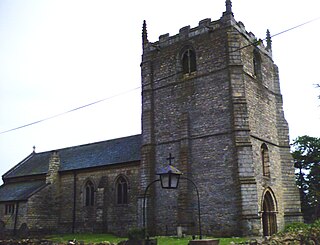
Grayingham is a village and civil parish in the West Lindsey district of Lincolnshire, England. The population of the civil parish at the 2011 census was 123 It is situated 1 mile (1.6 km) south from Kirton in Lindsey, 8 miles (13 km) north-east from Gainsborough and 8 miles south from Scunthorpe.

Fifield is a village and civil parish about 4 miles (6.4 km) north of Burford in Oxfordshire. The western boundary of the parish forms part of the county boundary with Gloucestershire. The 2011 Census recorded the parish's population as 240.

Harrington is a village and civil parish in Northamptonshire, England, administered by North Northamptonshire council. At the time of the 2001 census, the parish's population was 154 people, including Thorpe Underwood but reducing to 146 at the 2011 Census. The Church of England parish church of St Peter and St Paul is located north-east of the village itself.
Chacombe is a village and civil parish in West Northamptonshire, England, about 3 miles (5 km) north-east of Banbury. It is bounded to the west by the River Cherwell, to the north by a tributary and to the south-east by the Banbury–Syresham road. The 2011 Census gave a parish population of 659 and a 2019 estimate 693.

The Church of All Saints is the Church of England parish church of Lamport, Northamptonshire. It is a Grade I listed building and stands on the north side of the High Street.

St Andrew's Church is an Anglican church and the parish church of Old, Northamptonshire. It is a Grade I listed building and stands at Church Lane, on the south side of the village.
St Mary's Church is an Anglican church and the parish church of Welford. It is a Grade II* listed building and stands on the east side of the junction of Church Lane and West Street.

St Mary & All Saints' Church is an Anglican Church and the parish church of Holcot. It is a Grade II listed building and stands on the west side of Main Street.

St John the Baptist's Church is an Anglican Church and the parish church of Boughton. It is a Grade II listed building and stands on the east side of Church Street.

St Peter & St Paul's Church is an Anglican Church and the parish church of Watford, Northamptonshire. It is a Grade I listed building and stands on the west side of the Church Street.

St Michael & All Angels' Church is an Anglican Church and the parish church of Winwick, Northamptonshire. It is a Grade II* listed building.
St Helen's Church is an Anglican Church and the parish church of Oxendon. It is a Grade II* listed building and stands on the west side of Harborough Road, to the north of the village of Great Oxendon.
St Andrew's Church is an Anglican Church and the parish church of Arthingworth. It is a Grade II* listed building and stands on the north side of Braybrooke Road.
St John the Baptist's Church is an Anglican church, the parish church of East Farndon, Northamptonshire. It is a Grade I listed building and stands in the centre of the village of East Farndon.

St Catherine's Church is an Anglican Church and the parish church of Draughton in Northamptonshire. It is a Grade II* listed building and stands in the village of Draughton.

St Mary the Virgin's Church is an Anglican Church and the parish church of Maidwell, Northamptonshire. It is a Grade II* listed building and stands on the south side of Draughton Road.
This page is based on this
Wikipedia article Text is available under the
CC BY-SA 4.0 license; additional terms may apply.
Images, videos and audio are available under their respective licenses.

