Arthingworth | |
---|---|
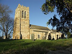
St. Andrew's Church, Arthingworth | |
Location within Northamptonshire | |
Population | 231 (2011) |
OS grid reference | SP755815 |
District | |
Shire county | |
Region | |
Country | England |
Sovereign state | United Kingdom |
Post town | MARKET HARBOROUGH |
Postcode district | LE16 |
Dialling code | 01858 |
Police | Northamptonshire |
Fire | Northamptonshire |
Ambulance | East Midlands |
UK Parliament | |
Arthingworth is a civil parish and village in the West Northamptonshire area of the county of Northamptonshire, England. [1] The population of the civil parish at the 2011 census was 238. [2]
The villages name probably means, 'enclosure connected with Earn(a)'. [3]
The nearest towns are Market Harborough about 4 miles (6.4 km) north and Kettering 9 miles (14.5 km) east via the A14 road which connects the town to the M1, M6 and M11 motorways.
Between 1859 and 1960 the village was served by Kelmarsh railway station about 1 mile south-west of the village and running trains between Northampton in the south and Market Harborough in the north.
The village has its own Parish Council. [4]
The Historic England website contains details of a total of eight listed buildings in the parish of Arthingworth, all of which are Grade II apart from St Andrew's Church, which is Grade II*. [5] They include:
Naseby is a village in West Northamptonshire, England. The population of the civil parish at the 2011 Census was 687.
Harborough is a local government district of Leicestershire, England, named after its main town, Market Harborough. Covering 230 square miles (600 km2), the district is by far the largest of the eight district authorities in Leicestershire and covers almost a quarter of the county.
East Farndon is a small linear village and civil parish about one mile south of Market Harborough in West Northamptonshire, England. The village is close to the border with Leicestershire, and has a Leicestershire post code and telephone dialling code. At the time of the 2001 census, the parish's population was 258 people, increasing to 307 at the 2011 census.
Welford is a village and civil parish in England, on the River Avon border between Northamptonshire and Leicestershire. At the 2011 census, the population was 1,043.
Brixworth is a large village and civil parish in West Northamptonshire, England. The 2001 census recorded a parish population of 5,162, increasing to 5,228 at the 2011 census. The village's All Saints' Church is of Anglo-Saxon origin.
Spratton is a village and civil parish in the English county of Northamptonshire. The local government authority is West Northamptonshire. Before changes in 2021 it was governed by Daventry District Council. At the time of the 2001 census, the parish's population was 1,099 people, increasing to 1,150 at the 2011 Census. Spratton is 7.1 miles north of Northampton, 6.5 miles from Long Buckby and 11.4 miles from Daventry. The village is situated on the A5199 road.
Old is a village and civil parish in West Northamptonshire, England. At the time of the 2001 census, the parish's population was 308 people, and the population increased to 490 at the 2011 Census.
Maidwell is a village and civil parish in West Northamptonshire in England. At the time of the 2001 census, the parish had 325 inhabitants, including Draughton, and this increased to 429 at the 2011 census.
Lamport is a village and civil parish in West Northamptonshire, England. The village is on the A508, about 8 miles (13 km) south of Market Harborough and 8 miles (13 km) north of Northampton. Nearby is Lamport Hall. At the time of the 2001 census, the parish's population was 207 people, including Hanging Houghton and increasing to 225 at the 2011 Census.
Kelmarsh is a village and civil parish in West Northamptonshire, England. The population of the civil parish at the 2011 Census was 208. The village is on the A508, close to its junction with the A14 about 5 miles (8 km) south of Market Harborough and 11 miles (18 km) north of Northampton.
Haselbech is a village and civil parish in West Northamptonshire in England. At the time of the 2001 census, the parish had a population of 87 people. The population remained less than 100 at the 2011 Census and was included in the civil parish of Kelmarsh.
Great Oxendon is a linear village and civil parish in West Northamptonshire in England. At the time of the 2001 census, the parish's population was 307 people, increasing to 331 at the 2011 Census.
Creaton is a village and civil parish in West Northamptonshire, England.
Sulgrave is a village and civil parish in West Northamptonshire, England, about 5 miles (8 km) north of Brackley. The village is just south of a stream that rises in the parish and flows east to join the River Tove, a tributary of the Great Ouse.
Kingsthorpe is a suburb and civil parish of Northampton, England. It is situated to the north of Northampton town centre and is served by the A508 and A5199 roads which join at Kingsthorpe's centre. The 2011 Census recorded the population of the district council ward as 4,477.
The A508 is a short A-class road for north–south journeys in south central England, forming the route from Market Harborough in Leicestershire, via Northampton, to Old Stratford, just outside Milton Keynes.
Oxendon was a rural district in Northamptonshire, England from 1894 to 1935.
Braybrooke is a small village in north west Northamptonshire, England. The population of the civil parish at the 2011 census was 378. It is situated about halfway between Market Harborough and Desborough. It lies in a valley between two ridges one of which is surmounted by the A6 trunk road. The surrounding land in the parish is a mixture of pasture and arable.
Harrington is a village and civil parish in Northamptonshire, England, administered by North Northamptonshire council. At the time of the 2001 census, the parish's population was 154 people, including Thorpe Underwood but reducing to 146 at the 2011 Census. The parish church of St. Peter and St. Paul is located north-east of the village itself.
Kelmarsh railway station on the Northampton and Market Harborough railway opened on 16 February 1859 serving the villages of Kelmarsh and Arthingworth, Northamptonshire, England. It ran almost equidistant between the two villages which are just under 2 miles (3.2 km) apart north-east of Kelmarsh and south-west of Arthingworth. It was part of the London and North Western Railway. The next station north, Clipston and Oxendon serving the villages of Great Oxendon and Clipston was situated south of Oxendon tunnel. To the south, Lamport was accessed via Kelmarsh tunnel.
Wikimedia Commons has media related to Arthingworth . |