
Naseby is a village in West Northamptonshire, England. The population of the civil parish at the 2011 Census was 687.

Alcester is a market town and civil parish in the Stratford-on-Avon District in Warwickshire, England. It is 8 mi (13 km) west of Stratford-upon-Avon, and 7 miles south of Redditch. The town dates back to the times of Roman Britain and is located at the junction of the River Alne and River Arrow.
Stanford Hall is a stately home in Leicestershire, England, near the village of Stanford on Avon and the town of Lutterworth, Leicestershire. The population of any residents in the area is included in the civil parish of Misterton with Walcote.

Harborough is a local government district in Leicestershire, England. It is named after its main town, Market Harborough, which is where the council is based. The district also includes the town of Lutterworth and numerous villages and surrounding rural areas. In the north of the district it includes parts of the Leicester Urban Area, notably at Thurnby, Bushby and Scraptoft. Covering 230 square miles (600 km2), the district is the largest by area of the eight districts in Leicestershire and covers almost a quarter of the county.

Welford is a village and civil parish in the West Northamptonshire unitary authority area of Northamptonshire, England, just south of the River Avon and the border with Leicestershire. At the 2011 Census, the population of the parish was 1,043.

Woodford Halse is a village about 6.5 miles (10.5 km) south of Daventry in Northamptonshire. It is in the civil parish of Woodford cum Membris, which includes also village of Hinton and hamlet of West Farndon. Hinton and Woodford Halse are separated by the infant River Cherwell and the former course of the Great Central Main Line railway. The village was formerly served by the Great Central Railway, which provided significant local employment, including Woodford Halse railway station which opened in 1899 and closed in 1966.

Lilbourne is a village and civil parish in West Northamptonshire in England. It is close to the M1 motorway which runs east of the village, and the A5 road, west of the village which marks the boundary with Warwickshire, slightly to the north is the River Avon which marks the boundary with Leicestershire. At the time of the 2001 census, the parish's population was 254 people, increasing to 273 at the 2011 Census, and further to 305 at the 2021 census.
Long Lawford is a village and civil parish in the Rugby borough of Warwickshire, England, located just west of Rugby, around 1.75 miles (2.82 km) west of Rugby town centre. In the 2021 census, the population of the parish was 4,545, a significant increase from 3,180 at the 2011 census, and 2,863 in 2001.

Barnwell is a village in North Northamptonshire in England, 2 miles (3.2 km) south of the town of Oundle, 78 miles (126 km) north of London and 14 miles (22.5 km) south-west of Peterborough. The River Nene runs north of the village, separating it from Oundle.

Sulgrave is a village and civil parish in West Northamptonshire, England, about 5 miles (8 km) north of Brackley. The village is just south of a stream that rises in the parish and flows east to join the River Tove, a tributary of the Great Ouse.

Stanford on Soar, known locally as Stanford, is a village and civil parish in the Rushcliffe district of Nottinghamshire, England near the River Soar.

Eydon is a village and civil parish in West Northamptonshire, about 8 miles (13 km) north-east of Banbury. The village is between 510 and 540 feet (160 m) above sea level on the east side of a hill, which rises to 580 feet (180 m) and is the highest point in the parish. The parish is bounded to the west by the River Cherwell, to the south by a stream that is one of its tributaries, and to the east and north by field boundaries.
Moreton Pinkney is a village and civil parish in West Northamptonshire, about 7.5 miles (12 km) north of Brackley. The 2011 Census recorded the parish's population as 371.

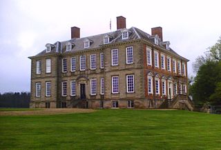
Westrill and Starmore is a civil parish in the Harborough district of Leicestershire, England. It has no settlement as such as it is one of the least populated parishes in Harborough District, comprising farmland surrounding the track from Stanford Park to Walcote village in the parish of Misterton with Walcote. The parish is located in the south of the county, on the border with Northamptonshire, between the parishes of Swinford and South Kilworth. The principal building in the parish is Stanford Hall, Leicestershire. To the south-east it faces the Northamptonshire parish of Stanford-on-Avon, across the River Avon.

Upton Scudamore is a village and civil parish in Wiltshire, England. The village lies about 1.8 miles (3 km) north of the town of Warminster and about the same distance south of Westbury. The parish includes the hamlet of Halfway.
Worleston is a village and civil parish in Cheshire, England, 2+1⁄2 miles north of Nantwich and 3 miles west of Crewe. The civil parish, which also includes Beambridge, Rease Heath, Mile End and Rookery, had a population at the 2011 Census of 452.

Ettington is a village and civil parish about 5.5 miles (9 km) south-east of Stratford-upon-Avon in Warwickshire, England. The 2011 Census recorded the parish's population as 1,171. The present village is on the A422 main road linking Stratford and Banbury. The A429 main road linking Warwick and Cirencester used to run through the village, and now uses a bypass just west of it. The Fosse Way Roman road crosses the A422 0.6 miles (1 km) east of the village.

Muston is a village and former civil parish, now in the parish of Bottesford, in the Melton district, in north-east Leicestershire, England. It is 18.6 miles (29.9 km) east of Nottingham, five miles (8.0 km) west of Grantham on the A52 and 12.5 miles (20.1 km) north of Melton Mowbray. It lies on the Leicestershire/Lincolnshire county border, two miles east of Bottesford. The River Devon flows through the village. In 1931 the parish had a population of 218. On 1 April 1936 the parish was abolished and merged with Bottesford.

Ratley is a village in the civil parish of Ratley and Upton, Stratford-on-Avon District, Warwickshire, England. The population of the civil parish in 2011 was 327. It is on the northwest side of the Edge Hill escarpment about 200 metres (660 ft) above sea level. The village is close to the county border with north Oxfordshire, some 7 miles northwest of Banbury, the closest town.

Loddington is a village and civil parish in the Harborough district of Leicestershire. It is on the county boundary with Rutland, and the nearest town is Oakham in Rutland, 6 miles (10 km) to the northeast.


