
Buckingham is a market town in north Buckinghamshire, England, close to the borders of Northamptonshire and Oxfordshire, which had a population of 12,890 at the 2011 Census. The town lies approximately 12 miles (19 km) west of Central Milton Keynes, 19 miles (31 km) south-east of Banbury, and 24 miles (39 km) north-east of Oxford.

Irthlingborough is a town on the River Nene in North Northamptonshire, England. As of 2021, it has a population of 9,325, and was at one point the smallest town in England to have had a Football League team, Rushden & Diamonds F.C.. The parish church, St Peter, has a lantern tower, unusual for Northamptonshire churches, which was built to guide travellers across the Nene valley in foggy weather. It also has doors at the four cardinal points and has eight misericords in the chancel.

Stowe is a civil parish and former village about two miles northwest of Buckingham in the unitary authority area of Buckinghamshire, England. The parish includes the hamlets of Boycott, Dadford and Lamport.

Luffield Abbey is a former civil parish, now in the parish of Lillingstone Dayrell with Luffield Abbey, in the very north of Buckinghamshire, England. It is on the border with Northamptonshire, close to Biddlesden and Silverstone.

Daventry District was a local government district in western Northamptonshire, England, from 1974 to 2021. The district was named after its main town of Daventry, where the council was based.

Brockhall is a civil parish and village in West Northamptonshire in England. Brockhall, like many estate villages, is a small settlement that has developed around its eponymous hall. The village - Brocole in Old English - was recorded in the Domesday Book. Brocole means "Badger hole". The name is derived from "broc" and "hol". The population is included in the civil parish of Norton.
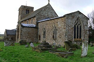
Upper Catesby is a hamlet in the civil parish of Catesby, Northamptonshire, about 3.5 miles (5.6 km) southwest of Daventry. The hamlet is about 550 feet (170 m) above sea level, at the top of a northwest-facing escarpment. The population is included in the civil parish of Hellidon.
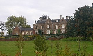
Church Stowe is a village in West Northamptonshire in England. It is the largest settlement in the civil parish of Stowe Nine Churches.

Lower Catesby is a hamlet in the civil parish of Catesby, Northamptonshire, about 4 miles (6.4 km) southwest of Daventry. Lower Catesby is beside the nascent River Leam, which rises about 1 mile (1.6 km) to the south in the parish of Hellidon. The Jurassic Way long-distance footpath passes through Lower Catesby. The population of the hamlet is included in the civil parish of Hellidon.
The Stowe School is a public school for pupils aged 13–18 in the English countryside of Stowe, England. It was opened on 11 May, 1923 at Stowe House, a Grade I Heritage Estate belonging to the British Crown. Formerly the country seat of the Dukes of Buckingham and Chandos, it was first constructed in 1677 and served as a consulate to monarchy and aristocracy throughout the 18th and 19th centuries. J. F. Roxburgh was the school's first headmaster.

Weedon Bec, usually just Weedon, is a village and parish in West Northamptonshire, England. It is close to the source of the River Nene. The population of the civil parish at the 2011 census was 2,706.
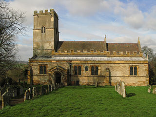
Stowe Nine Churches, also written as Stowe IX Churches, is a civil parish incorporating the settlements of Church Stowe and Upper Stowe in the West Northamptonshire district, in the ceremonial county of Northamptonshire, England. The population of the parish at the 2011 census was 259.
Boddington is a civil parish in West Northamptonshire, England, about 5 miles (8 km) north-east of Banbury off the A361 road.

All Saints' Church is a noted Anglo-Saxon Church of England parish church in Earls Barton, Northamptonshire. It is estimated that the building dates from the later tenth century, shortly after Danish raids on England.

Wardington is a village and civil parish in Oxfordshire, about 4 miles (6.4 km) northeast of Banbury. The village consists of two parts: Wardington and Upper Wardington. The village is on a stream that rises in Upper Wardington and flows north to join the River Cherwell.
Stowe, Northamptonshire could refer to the following places in England:

Nether Heyford is a village and civil parish in West Northamptonshire, England, close to the M1 motorway and the A5 and A45 roads, 6 miles (10 km) west of Northampton and 70 miles (113 km) northwest of London. The smaller village of Upper Heyford is about half a mile to the north.

West Northamptonshire is a unitary authority area in the ceremonial county of Northamptonshire, England, and was created in 2021. It contains the county town of Northampton, as well as Daventry, Brackley and Towcester; the rest of the area is predominantly agricultural villages though it has many lakes and small woodlands.

Robert Allan White is a former English professional cricketer and current umpire.

