Kilsby

Last updated

Kilsby
Kilsby Main Road - geograph.org.uk - 1220833.jpg
Kilsby Main Road
Northamptonshire UK location map.svg
Red pog.svg
Kilsby
Location within Northamptonshire
Population1,268 (2020 est)
OS grid reference SP562712
Civil parish
  • Kilsby
Unitary authority
Ceremonial county
Region
Country England
Sovereign state United Kingdom
Post town RUGBY
Postcode district CV23
Dialling code 01788
Police Northamptonshire
Fire Northamptonshire
Ambulance East Midlands
UK Parliament
List of places
UK
England
Northamptonshire
52°20′10″N1°10′28″W / 52.336061°N 1.17435°W / 52.336061; -1.17435 Coordinates: 52°20′10″N1°10′28″W / 52.336061°N 1.17435°W / 52.336061; -1.17435

Kilsby is a village and civil parish in West Northamptonshire, England. It is situated a short distance south of the border with Warwickshire approximately five miles southeast of Rugby. The parish of Kilsby, which includes Barby Nortoft, was estimated to have a population of 1,268 in 2020. [1]

Contents

History

Kilsby's name comes from Anglo-Saxon cildes + old Norse býr, literally meaning "child's dwelling", but "child" here probably means "young nobleman". [2] Its church, St Faith's, may originally have been the daughter chapel of the neighbouring parish of Barby.[ citation needed ]

The parish's eastern side is bounded by the old route of the Roman Watling Street, and the village itself is sited on the crossing of two former mediaeval drove-routes. [3]

One of the earliest armed confrontations of the English Civil War took place at Kilsby in August 1642: The Royalist Captain Sir John Smith led a group of soldiers to disarm the villagers, after the news was heard that they were Parliamentarian supporters. The villagers put up resistance, and in the ensuing fight, several villagers were killed. [4]

Kilsby gives its name to the Kilsby Tunnel; a railway tunnel on the West Coast Main Line. The construction of the tunnel between 1835 and 1838 caused considerable disruption to the village, as more than 1,200 navvies lived in a shanty town on the edge of the village, using 200 horses and thirteen steam engines to construct it. The navvies were known for their heavy drinking in the local inns, and on one occasion, troops from the nearby Weedon barracks were called in to quell a riot. [4] The tunnel measures 1 mile 666 yards (2,216 m).[ citation needed ]

"Kilsby Jones" is the name by which James Rhys Jones is usually known. He was a Welsh congregationalist minister and writer in Kilsby from 1840 to about 1850, when he moved to Birmingham. [5]

The village has grown moderately since the 1960s, with a mix of new housing developments and a degree of in-filling. It retains a historic core of attractive buildings including some fine examples of Northamptonshire rubble stone construction, and a number of thatched properties. A Conservation area was designated in the village in 2018, and many of the village's more attractive properties are listed for their historic interest.[ citation needed ]

Landmarks and amenities

St Faith's Church, Kilsby St Faith, Kilsby.jpg
St Faith's Church, Kilsby
The crenelated top of one of the ventilation shafts of the Kilsby Tunnel, visible from the A5 road Kilsby Tunnel Airshaft - geograph.org.uk - 1607032.jpg
The crenelated top of one of the ventilation shafts of the Kilsby Tunnel, visible from the A5 road

Amenities in the village include an Ofsted "Good" rated primary school, two pubs, The Red Lion and The George and two churches - Church of England and URC.[ citation needed ]

The Village also has a volunteer-run, community-owned shop in the car park of the Red Lion pub. This warm community spirit is also evident in a number of thriving community groups, including Womans Institute, Brownies, Girl Guides, as well as a good neighbour community support scheme born out of the 2020 COVID-19 lockdown and the Kilsby Kronicle village newspaper.[ citation needed ]

The two 1830s ventilation shafts of the Kilsby Tunnel designed by Robert Stephenson are topped with circular crenelated turrets. These structures, visible from the A5 road, are listed buildings. [6] [7]

Transport

The village is circa 10 minutes from both Long Buckby and Rugby stations, the latter offering direct services into London Euston in 49 minutes. Between 1881 and 1960, the village used to have a railway station Kilsby and Crick station but this was on the Northampton Loop about a mile (1.5 km) from the village.[ citation needed ]

One of the village's more unusual claims to fame is that the A361 road terminates here at a junction with the A5. The A361 runs to Ilfracombe in Devon making it the longest 'three-digit' road in Britain. A consequence of these roads is that the majority of through traffic bypasses the heart of the village ensuring the main road through the village is relatively quiet.[ citation needed ]

Related Research Articles

<span class="mw-page-title-main">Box Tunnel</span> Railway tunnel in western England

Box Tunnel passes through Box Hill on the Great Western Main Line (GWML) between Bath and Chippenham. The 1.83-mile (2.95 km) tunnel was the world's longest railway tunnel when it was completed in 1841.

<span class="mw-page-title-main">Eye, Cambridgeshire</span> Human settlement in England

Eye is a village in the unitary authority area of Peterborough, in the ceremonial county of Cambridgeshire, England. The village is 4.5 miles (7 km) south from Crowland. The hamlet of Eye Green is 1⁄2 mile to the north, separated by the A47 trunk road.

<span class="mw-page-title-main">Naseby</span> Human settlement in England

Naseby is a village in West Northamptonshire, England. The population of the civil parish at the 2011 Census was 687.

<span class="mw-page-title-main">Daventry</span> Market town and civil parish in Northamptonshire, England

Daventry is a market town and civil parish in the West Northamptonshire unitary authority in Northamptonshire, England, close to the border with Warwickshire. At the 2021 Census Daventry had a population of 28,123, making it the sixth largest town in Northamptonshire.

<span class="mw-page-title-main">Kilsby Tunnel</span> Railway tunnel in Northamptonshire, England

The Kilsby Tunnel is a railway tunnel on the West Coast Main Line in England, near the village of Kilsby in Northamptonshire, roughly 5 miles (8 km) southeast of Rugby. It is 2,423 yards (2,216 m) long.

<span class="mw-page-title-main">Bramhope</span> Village and civil parish in West Yorkshire, England

Bramhope is a village and civil parish in the City of Leeds metropolitan borough, West Yorkshire, England, north of Holt Park and north east of Cookridge.

<span class="mw-page-title-main">Welford, Northamptonshire</span> Human settlement in England

Welford is a village and civil parish in England, on the River Avon border between Northamptonshire and Leicestershire. At the 2011 census, the population was 1,043.

<span class="mw-page-title-main">Crick, Northamptonshire</span> Human settlement in England

Crick is a village in West Northamptonshire in England. It is close to the border with Warwickshire, six miles east of Rugby and 14 miles (23 km) northwest of Northampton. The villages of Crick and West Haddon were by-passed by the A428 main road from Rugby to Northampton when the Daventry International Rail Freight Terminal (DIRFT) was built in 1996. The terminal is a short distance east of junction 18 of the M1 motorway, which is next to Crick. Crick's population in the 2001 census was 1,460, increasing to 1,886 at the 2011 census.

<span class="mw-page-title-main">Badby</span> Human settlement in England

Badby is a village and a rural parish of about 2,020 acres (820 ha) in West Northamptonshire, England.

<span class="mw-page-title-main">Barby, Northamptonshire</span> Village in Northamptonshire, England

Barby is a village and civil parish about 5 miles (8 km) north of Daventry in Northamptonshire, England. The 2011 Census recorded the parish population as 2,336. Barby is located right off the M45 motorway a short spur from the M1 motorway to the A45 Trunk Road.

<span class="mw-page-title-main">Staverton, Northamptonshire</span> Human settlement in England

Staverton is a village and civil parish in the south-west of Northamptonshire, England. It is 2.3 miles west of Daventry, 7.9 miles east of Southam and 15.3 miles east of Leamington Spa. It straddles the A425 road from Daventry to Leamington. The Jurassic Way long-distance footpath between Banbury and Stamford passes through the village.

<span class="mw-page-title-main">Croughton, Northamptonshire</span> Village and civil parish in England

Croughton is a village and civil parish in West Northamptonshire, England, about 3 miles (5 km) southwest of Brackley. The 2011 Census recorded the parish's population as 992.

<span class="mw-page-title-main">Hellidon</span> Village in Northamptonshire, England

Hellidon is a village and civil parish about 5 miles (8 km) south-west of Daventry in Northamptonshire, England. The parish area is about 1,600 acres (650 ha). It lies 520 feet (160 m) – 590 feet (180 m) above sea level on the north face of an ironstone ridge, its highest point, 670 feet (200 m) at Windmill Hill, being 0.5 miles (800 m) south-east of the village. The Leam and tributaries rise in the parish. The 2011 Census gave a population of 256, estimated at 286 in 2019. The long-distance Jurassic Way footpath linking Banbury, Oxfordshire, and Stamford, Lincolnshire, passes through. The origin of the name is unclear. "Holy Valley", "Haegla's Valley" and "Unstable valley" have been suggested, with the Old English "dun", meaning hill.

Great Oxendon is a linear village and civil parish in West Northamptonshire in England. At the time of the 2001 census, the parish's population was 307 people, increasing to 331 at the 2011 Census.

<span class="mw-page-title-main">Willoughby, Warwickshire</span> Human settlement in England

Willoughby is a village and civil parish about 5 miles (8 km) south of Rugby, Warwickshire, England. The village is about 4.5 miles (7 km) northwest of Daventry in neighbouring Northamptonshire and the eastern boundary of the parish forms part of the county boundary.

<span class="mw-page-title-main">Weedon Bec</span> Human settlement in England

Weedon Bec, usually just Weedon, is a village and parish in West Northamptonshire, England. It is close to the source of the River Nene. The population of the civil parish at the 2011 census was 2,706.

<span class="mw-page-title-main">Warmington, Northamptonshire</span> Human settlement in England

Warmington is a village and civil parish in North Northamptonshire, England with a population of 874, increasing to 939 at the 2011 Census.

<span class="mw-page-title-main">Anderby</span> Village and civil parish in the East Lindsey district of Lincolnshire, England

Anderby is a village and civil parish in the East Lindsey district of Lincolnshire, England. It has a population of 335, according to the 2001 Census. increasing to 382 at the 2011 census.

<span class="mw-page-title-main">East Hunsbury</span> Human settlement in England

East Hunsbury is a large residential area in the south of the town of Northampton, England, 3 miles (5 km) from the town centre and 1 mile (2 km) from junction 15 of the M1 motorway. For administrative purposes it is part of the unitary authority of West Northamptonshire. It is part of the Hunsbury residential area, which also includes West Hunsbury on the west side of Towcester Road. Shelfleys is the original name for the area of Northampton currently referred to as West Hunsbury. The name of West Hunsbury still appears on maps for the district as Shelfleys. Merefield is the corresponding name for East Hunsbury, together with the name "Blackymore" for the eastern part of East Hunsbury. All three names are still on local direction signs in Northampton, although older references are no longer in use by the local people living there. The areas developed in the 1980s and 1990s as part of the expansion of Northampton. The Northampton loop of the West Coast Main Line railway running between Northampton and London Euston runs under East and West Hunsbury via the Hunsbury Hill Tunnel emerging near Hill Farm Rise which follows the original course of Towcester Road prior to the 1980s. Ventilation shafts are visible in the housing estate in Yeoman Meadow. East Hunsbury was awarded ‘Best Large Village’ in 2019 by NorthantsAcre.

<span class="mw-page-title-main">Bramhope Tunnel</span> Railway tunnel in West Yorkshire, England

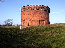
Bramhope Tunnel is on the Harrogate Line between Horsforth station and the Arthington Viaduct in West Yorkshire, England. Services through the railway tunnel are operated mainly by Northern. The tunnel was constructed during 1845–1849 by the Leeds and Thirsk Railway. It is notable for its 2.138-mile (3.441 km) length and its Grade II listed, crenellated north portal. The deaths of 24 men who were killed during its construction are commemorated in Otley churchyard by a monument that is a replica of the tunnel's north portal.

References

  1. "KILSBY Parish in East Midlands". City Population. Retrieved 29 November 2021.
  2. "Kilsby History, Gren Hatton". Archived from the original on 19 August 2011. Retrieved 10 November 2009.
  3. Kilsby village website
  4. 1 2 The Northamptonshire Village Book. NFWI and Countryside Books. 1989. pp. 105–106. ISBN   1-85306-055-0.
  5. Lee, Sidney, ed. (1892). "Jones, James Rhys"  . Dictionary of National Biography . Vol. 30. London: Smith, Elder & Co.
  6. Historic England. "North Ventilation Shaft, Kilsby Tunnel (1076406)". National Heritage List for England . Retrieved 1 March 2023.
  7. Historic England. "South Ventilation Shaft, Kilsby Tunnel (1343043)". National Heritage List for England . Retrieved 1 March 2023.