
Nash is a village and also a civil parish in Buckinghamshire, England, within the Buckinghamshire Council unitary authority area. It is in the north of the county, about 5 miles (8.0 km) south-west of Milton Keynes and 4 miles (6.4 km) east of Buckingham. According to the 2011 census, the population total of Nash was 417.

Shipton Lee is a hamlet and former civil parish, now in the parish of Quainton, in the county of Buckinghamshire, England. In 1881 the parish had a population of 61. From 1866 to 1886 Shipton Lee was a civil parish in its own right. On 25 March 1886 the parish was abolished and merged with Quainton.

Teeton is a village and former civil parish, now in the parish of Hollowell, in the West Northamptonshire district, in the ceremonial county of Northamptonshire, England. In 1931 the parish had a population of 55. In 1866 Teeton became a civil parish, on 1 April 1935 the parish was abolished and merged with Hollowell.
Ravensthorpe is a village and civil parish in West Northamptonshire in England. The village lies approximately midway between Northampton and Rugby. The M1 motorway is six miles west and the nearest railway station is at Long Buckby. At the time of the 2001 census, the parish's population was 656 people, including Coton but falling slightly to 646 at the 2011 census.
Hanging Houghton is a small village and former civil parish, now in the parish of Lamport, in the West Northamptonshire district, in the ceremonial county of Northamptonshire, England. It is on the A508 road between Brixworth and Lamport. In 1931 the parish had a population of 84.
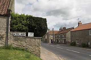
Aislaby is a hamlet and civil parish near the English town of Pickering, North Yorkshire. It lies on the A170 to the west of Pickering between Wrelton and Middleton.
Gunthorpe is a residential area of the city of Peterborough, in the ceremonial county of Cambridgeshire, England. Since 2015 Gunthorpe has its own ward within Peterborough City Council that also encompasses parts of South Werrington.
Abington is a district of the town of Northampton and former civil parish, now in the parish of Northampton, in the West Northamptonshire district, in the ceremonial county of Northamptonshire, England, situated about 2 miles (3.2 km) east of the town centre. The population of the ward of Northampton Borough Council at the 2011 census was 9,668.

Little Oakley is a village and former civil parish, now in the parish of Newton and Little Oakley, in the North Northamptonshire district, in the ceremonial county of Northamptonshire, England. It is situated between Corby and Kettering. In 1931 the parish had a population of 85. On 1 April 1935 the parish was abolished and merged with Great Oakley to form Oakley. Inside the village is St. Peter's church, which dates from the thirteenth century. Opposite the church is Primrose Cottage, a stone-built cottage dating back to the seventeenth century, where several generations of one family once lived and are now buried in the church yard.

Wotton is a suburb of Gloucester, in the county of Gloucestershire, England. It is situated close to the city centre, the Royal Hospital, the city's railway station and to London Road.

Almer is a village and former civil parish, now in the parish of Sturminster Marshall, in the Dorset district, in the ceremonial county of Dorset, England. Almer is located on the A31 road near Winterborne Zelston, Huish Manor, Sturminster Marshall and opposite the Drax estate. The main features of the village are Almer Manor, Almer Parish church and the old school house. The school was co-educational; it opened in 1925 and closed in 1964. The Almer School Honours tablet is now kept in Winterborne Zelston village hall. The seven residential properties in Almer are owned and let by the Charborough (Drax) Estate. In 1931 the parish had a population of 108. On 1 April 1933 the parish was abolished and merged with Sturminster Marshall.

Armston is a hamlet and former civil parish, now in the parish of Polebrook, in the North Northamptonshire district, in the ceremonial county of Northamptonshire, England. In 1931 the parish had a population of 22.

Ashton is a hamlet and former civil parish, now in the parish of Bainton, in the Peterborough district, in the ceremonial county of Cambridgeshire, England. In 1881 the parish had a population of 106.

Atterton is a hamlet and former civil parish, now in the parish of Witherley, in the Hinckley and Bosworth district, in the county of Leicestershire, England. It has a population of approximately 40 people. In 1931 the parish had a population of 43.

East Stratton is an estate village and former civil parish, now in the parish of Micheldever, in the Winchester district, in the county of Hampshire, England. It is at the entrance to the landscaped grounds of Stratton Park, some 8 miles northeast of Winchester Both park and village demonstrate the evolution of a landscape directed by three eminent families - Wriothesley, Russell and Baring - during the 17th, 18th and 19th centuries. In 1931 the parish had a population of 230.

Lutley is a hamlet and former civil parish near Halesowen, in the Dudley district, in the county of the West Midlands, England. Lutley Mill is nearby in Halesowen and is also the name of a local pub. Lutley Mill is situated on Puddings Brook. The Lutley Gutter runs through Lutley. In 1951 the parish had a population of 457.

Woodthorpe is a hamlet just south of Loughborough and former civil parish, now in the unparished area of Loughborough, in the Charnwood district, in Leicestershire, England. In 1931 the parish had a population of 53.

Denton is a hamlet and former civil parish, now in the parish of Cuddesdon and Denton, in the South Oxfordshire district, in Oxfordshire, England. Denton's toponym is derived from the Old English den-tun meaning "valley farmstead". Denton is in a fold of the landscape, between the two hills on which Cuddesdon and Garsington stand. Denton is an ancient manor and had its own civil parish, but it was merged with neighbouring Cuddesdon in the 20th century.
Pilsgate is a hamlet and former civil parish, now in the parish of Barnack, in the Peterborough district, in the ceremonial county of Cambridgeshire, England. Pilsgate is close to the county boundary and 3 miles (5 km) south-east of Stamford, Lincolnshire. In 1881 the parish had a population of 125.

Thorney is a village and civil parish about 2 and a half miles south west of Saxilby railway station, in the Newark and Sherwood district, in the county of Nottinghamshire, England. In 2011, the parish had a population of 248. The parish touches Wigsley, Kettlethorpe, Newton on Trent, Saxilby with Ingleby, Harby, North Clifton, South Clifton and Hardwick.


