Staverton, Northamptonshire

Last updated

Staverton
Staverton 22,04,2007.JPG
Northamptonshire UK location map (2021).svg
Red pog.svg
Staverton
Location within Northamptonshire
Population458 (2011 Census)
OS grid reference SP539612
Unitary authority
Ceremonial county
Region
Country England
Sovereign state United Kingdom
Post town DAVENTRY
Postcode district NN11
Dialling code 01327
Police Northamptonshire
Fire Northamptonshire
Ambulance East Midlands
UK Parliament
List of places
UK
England
Northamptonshire
52°14′46″N1°12′36″W / 52.246°N 1.210°W / 52.246; -1.210

Staverton is a village and civil parish in the south-west of Northamptonshire, England. [1] It is 2.3 miles west of Daventry, 7.9 miles east of Southam and 15.3 miles east of Leamington Spa. It straddles the A425 road from Daventry to Leamington. The Jurassic Way long-distance footpath between Banbury and Stamford passes through the village.

Contents

The village sits on the edge of an escarpment and has views westward across the valley of the River Leam into the neighbouring county of Warwickshire. Both the Malvern and Shropshire hills are visible on fine days.

History

The village's name means 'Stake farm/settlement', either set apart by such or where they were made or acquired. [2]

In the Domesday Book of 1086, Staverton is mentioned as Stavertone. [3]

Before the early part of the 18th century, the original village was located behind the church. However, in 1720 a fire broke out which caused damage, destroying many haystacks, stables, grain stores and 22 houses. The total loss was thought to be around £3,000. The result of this was that the village received, via a bequest from Elizabeth Darby, a fire engine. This came into commission in 1767, was kept in the village until quite recently and was later housed at the Daventry museum. A plaque can be seen on a door opposite the village green to this effect.

The village green Staverton village 22,04,2007 (3).JPG
The village green

The village has a manor house, situated at the end of Manor Road and thought to have parts originating possibly from Anglo-Saxon times. It is only one of many examples of vernacular architecture in the village. There is an interesting window detail at The Stables in Manor Road. A datestone above the window reads R.R. 1684.

Within the village, Well Lane runs parallel to the main A425. It has been conjectured that this was a much earlier approach to the village. The deeply banked sides to the lane bear testimony to it being an ancient right of way. Possibly, with the increase in coaching traffic from the west, the present A425 route was chosen in preference.

Along the western boundary of the parish runs the now-disused railway, the last mainline railway to be built in Britain. It was constructed by the Great Central Railway Company between 1894 and 1899 and ran from Nottingham Victoria to London Marylebone. A mission was established for the navvies [4] in the village in a barn situated on the corner of Manor Road and Glebe Lane. This is now part of a private residence.

Geography

The average elevation of the parish is 700 ft above sea level, and approximately 1.5 miles south of the village is Arbury Hill, which, at 225 m (738 ft), is the highest point in Northamptonshire. On the summit, evidence of an Iron Age hill fort of an unusually square shape is plainly seen. [5] The River Nene rises nearby. The Jurassic Way and the Three Rivers Circular Walk pass through the parish.

Demography

Staverton parish had a population of 468 at the 2001 census, [6] reducing slightly to 458 at the 2011 Census. [7]

Landmarks

Staverton Church Staverton Parish Church 22,04,2007.JPG
Staverton Church

St Mary the Virgin has been a site of Christian worship for well over a thousand years, although the first recorded vicar appears in records started in 1220. A board inside the church lists all subsequent vicars up to the present incumbent. The present church dates from about 1300 with some older parts. [8] For hundreds of years before this, possibly dating back to before 800 AD, a burial ground existed on the site - as evidenced by the raised churchyard. The main structure that can be seen today dates mainly from the 14th century, although traces of older architecture still remain, such as the lancet window in the north-west corner, which is from the Norman period.

The church has many original architectural and historic features. From the top of the tower, sitting on top of one of the highest points in Northamptonshire, it is said that if one were able to travel eastwards maintaining the same altitude, one would not touch land again until reaching the Urals. The ‘new’ north porch, used as the main entrance into the church, dates back 600 years, whereas the south porch is 100 years older. The original door and roof timbers remain. The church has a peal of six bells cast in 1938 by John Taylor & Co of Loughborough. The vicar from 1933 to 1946, Rev. E.S. Powell, initiated the bell restoration; he and his wife were active bellringers.

Transport

There is a bus service 65 between Leamington-Southam-Banbury, operated by Stagecoach in Warwickshire from Monday to Saturday. The closest railway is the West Midlands Trains service from Long Buckby station on the Northampton loop of the West Coast Main Line. Nearby Northampton and Rugby stations are served by Avanti West Coast services, while Chiltern Railways. CrossCountry and West Midlands Trains trains can be joined at Leamington Spa or Banbury.

Amenities

There is one public house, The Countryman, formerly known as the New Inn. Former Staverton pubs included The Windmill in Windmill Lane and The Crown, now a private house, opposite The Green. Across the road from the pub, there is a garage. There is a garden centre on the Badby Road out of the village. East of the village on the Daventry road is De Vere Staverton Estate, a hotel where the facilities include an indoor leisure complex and an 18-hole golf course and driving range.

The first mention of a post office in the village was in 1864, but the post office closed in March 2008. [9]

Related Research Articles

<span class="mw-page-title-main">Braunston</span> Human settlement in England

Braunston is a village and civil parish in the West Northamptonshire, district, in the ceremonial county of Northamptonshire, England, next to the border with Warwickshire. At the 2011 Census, the parish had a population of 1,759. Braunston is situated just off the A45 main road and lies between the towns of Daventry and Rugby. Braunston is categorised by the Office for National Statistics as Suburbs and Small Towns: Suburbs There are 776 households in the village.

<span class="mw-page-title-main">Naseby</span> Human settlement in England

Naseby is a village in West Northamptonshire, England. The population of the civil parish at the 2011 Census was 687.

<span class="mw-page-title-main">Daventry</span> Market town and civil parish in Northamptonshire, England

Daventry is a market town and civil parish in the West Northamptonshire unitary authority in Northamptonshire, England, close to the border with Warwickshire. At the 2021 Census Daventry had a population of 28,123, making it the sixth largest town in Northamptonshire.

<span class="mw-page-title-main">Southam</span> Human settlement in England

Southam is a market town and civil parish in the Stratford-on-Avon district of Warwickshire, England. Southam is situated on the River Stowe, which flows from Napton-on-the-Hill and joins Warwickshire's River Itchen at Stoneythorpe, just outside the town.

<span class="mw-page-title-main">Badby</span> Human settlement in England

Badby is a village and a rural parish of about 2,020 acres (820 ha) in West Northamptonshire, England.

<span class="mw-page-title-main">Barby, Northamptonshire</span> Village in Northamptonshire, England

Barby is a village and civil parish about 5 miles (8 km) north of Daventry in Northamptonshire, England. The 2011 Census recorded the parish population as 2,336. Barby is located right off the M45 motorway a short spur from the M1 motorway to the A45 Trunk Road.

<span class="mw-page-title-main">Broadwell, Warwickshire</span> Human settlement in England

Broadwell is a village in Warwickshire, England in the civil parish of Leamington Hastings roughly midway between Dunchurch and Southam on the A426 road.

<span class="mw-page-title-main">Hellidon</span> Village in Northamptonshire, England

Hellidon is a village and civil parish about 5 miles (8 km) south-west of Daventry in Northamptonshire, England. The parish area is about 1,600 acres (650 ha). It lies 520 feet (160 m) – 590 feet (180 m) above sea level on the north face of an ironstone ridge, its highest point, 670 feet (200 m) at Windmill Hill, being 0.5 miles (800 m) south-east of the village. The Leam and tributaries rise in the parish. The 2011 Census gave a population of 256, estimated at 286 in 2019. The long-distance Jurassic Way footpath linking Banbury, Oxfordshire, and Stamford, Lincolnshire, passes through. The origin of the name is unclear. "Holy Valley", "Haegla's Valley" and "Unstable valley" have been suggested, with the Old English "dun", meaning hill.

<span class="mw-page-title-main">River Itchen, Warwickshire</span> River in east Warwickshire, England

The River Itchen flows through east Warwickshire in England. It is a small river, about 18 miles (29 km) long, and its general course is from south to north.

<span class="mw-page-title-main">Willoughby, Warwickshire</span> Human settlement in England

Willoughby is a village and civil parish about 5 miles (8 km) south of Rugby, Warwickshire, England. The village is about 4.5 miles (7 km) northwest of Daventry in neighbouring Northamptonshire and the eastern boundary of the parish forms part of the county boundary.

<span class="mw-page-title-main">Thorpe Mandeville</span> Human settlement in England

Thorpe Mandeville is a village and civil parish in West Northamptonshire, England about 6 miles (10 km) northeast of Banbury in neighbouring Oxfordshire. The hamlet of Lower Thorpe is just north of the village.

<span class="mw-page-title-main">Flecknoe</span> Human settlement in England

Flecknoe is a village in the Rugby district of Warwickshire, England, one mile west of the border with Northamptonshire. The village is the largest settlement within the civil parish of Wolfhampcote, and has a population of around 200. The village was mentioned in the Domesday Book as Flachenho, probably meaning "Flecca's hill". The village is shown as Fleckno on the Christopher Saxton map of 1637.

<span class="mw-page-title-main">Sulgrave</span> Human settlement in England

Sulgrave is a village and civil parish in West Northamptonshire, England, about 5 miles (8 km) north of Brackley. The village is just south of a stream that rises in the parish and flows east to join the River Tove, a tributary of the Great Ouse.

<span class="mw-page-title-main">Leamington Hastings</span> Human settlement in England

Leamington Hastings is a small village and larger civil parish in Warwickshire, England. The civil parish covers Leamington Hastings itself, plus the nearby hamlets of Broadwell, Hill and Kites Hardwick. Its population in the 2011 census was 440, increasing slightly to 466 at the 2021 census.

<span class="mw-page-title-main">Harbury</span> Human settlement in England

Harbury is a village and civil parish in the Stratford-on-Avon district of Warwickshire, England. It is about 3 miles (5 km) west-southwest of Southam and about 5 miles (8 km) southeast of Royal Leamington Spa. The parish includes the hamlet of Deppers Bridge. The 2011 Census recorded the parish's population as 2,420. The village is on a ridge of lias up to 390 feet (119 m) high that runs roughly northeast – southwest. The parish covers 3,397 acres (1,375 ha). It is bounded by the River Itchen to the east, Fosse Way to the northwest, a minor road to the south and field boundaries on its other sides. Adjoining parishes are Bishop's Itchington, Bishop's Tachbrook, Chesterton, Ladbroke and Southam. The A425 road and the Chiltern Main Line pass through the parish just north of Harbury village. Junction 12 on the M40 motorway is about 3 miles (5 km) south of the village.

<span class="mw-page-title-main">Marton, Warwickshire</span> Village and civil parish in Warwickshire, England

Marton is a village and civil parish in Warwickshire, England. The parish is within the Borough of Rugby and in the 2011 Census' had a population of 484. The hamlet of Marton Moor lies south of the village.

<span class="mw-page-title-main">Cubbington</span> Human settlement in England

Cubbington is a village and civil parish with a population of 3,929, adjoining the north-eastern outskirts of Leamington Spa, Warwickshire, England, approximately 3 miles from the town centre. Welsh Road, running through the village crossroads, was an old sheep drovers' route connecting London and Wales. Since the 1950s when the village expanded there have been two parts to the village: Cubbington proper which was the old village core, and New Cubbington which is to the west, although both are referred to as Cubbington. Topographically the highest point of the village sits about 100 metres (330 ft) above sea level while its lowest is about 60 metres (200 ft). For many years the electorate for Cubbington was represented in government by the MP for Warwick and Leamington but for the 2010 UK Elections it moved to the new Kenilworth & Southam constituency.

<span class="mw-page-title-main">Wardington</span> Human settlement in England

Wardington is a village and civil parish in Oxfordshire, about 4 miles (6.4 km) northeast of Banbury. The village consists of two parts: Wardington and Upper Wardington. The village is on a stream that rises in Upper Wardington and flows north to join the River Cherwell.

<span class="mw-page-title-main">Braunston and Willoughby railway station</span> Former railway station in Warwickshire, England

Braunston and Willoughby railway station was a station on the former Great Central Main Line. It served the small village of Willoughby which it was located next to, and the larger but more distant village of Braunston. The station opened with the line on 15 March 1899.

<span class="mw-page-title-main">Rugby–Leamington line</span> Disused railway in Warwickshire, England

The Rugby to Leamington Line was a railway line running from Rugby to Leamington Spa. It was a 15-mile (24 km) branch line built by the London and North Western Railway (LNWR) and opened in 1851. The branch connected Leamington with the mainline from London to Birmingham which had been opened in 1838 by the LNWR's predecessor, the London and Birmingham Railway (L&BR).
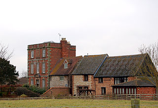
References

  1. OS Explorer Map 222 Rugby & Daventry, Southam & Lutterworth ISBN   978-0-319-23734-2
  2. "Key to English Place-names".
  3. The Domesday Book, Englands Heritage, Then and Now, Editor: Thomas Hinde, Northamptonshire page 203 ISBN   1-85833-440-3
  4. Navvies in Staverton
  5. An Inventory of Archaeological Sites in North West Northamptonshire,Staverton (BCS 792). ISBN   0-11-700900-8
  6. Office for National Statistics: Staverton CP: Parish headcounts. Retrieved 21 November 2009
  7. "Civil Parish population 2011". Neighbourhood Statistics. Office for National Statistics. Retrieved 10 July 2016.
  8. The Buildings of England, Northamptonshire, by Nikolaus Pevsner, 2nd Edition revised by Bridget Cherry, Whilton entry. ISBN   0-14-071022-1
  9. Daventry Express, 28 February 2008