Marston Trussell

Last updated

Marston Trussell
Northamptonshire UK location map.svg
Red pog.svg
Marston Trussell
Location within Northamptonshire
Population157 (2011)
OS grid reference SP6985
Unitary authority
Ceremonial county
Region
Country England
Sovereign state United Kingdom
Post town Market Harborough
Postcode district LE16
Dialling code 01858
Police Northamptonshire
Fire Northamptonshire
Ambulance East Midlands
UK Parliament
List of places
UK
England
Northamptonshire
52°27′43″N0°59′01″W / 52.4619°N 0.9837°W / 52.4619; -0.9837 Coordinates: 52°27′43″N0°59′01″W / 52.4619°N 0.9837°W / 52.4619; -0.9837

Marston Trussell is a village and civil parish in West Northamptonshire in England. Marston Trussell was first recorded as 'Mersitone', meaning marsh settlement. The parish includes Thorpe Lubenham. At the time of the 2001 census, its population was 163 people, [1] reducing slightly to 157 at the 2011 census but including Lubenham. [2]

Contents

The villages name means 'Marsh farm/settlement'. The village was held by Richard Trussel in 1233. [3]

The manor house in the village, Marston Trussell Hall, dates from circa 1606 and is an Elizabethan-style mansion with fine wood panelling interiors in the drawing room; in later years the existing house was dwarfed by a Victorian extension which no longer exists. A priesthole was discovered in the mid-1950s. The 12-acre (49,000 m2) grounds of the hall have gardens and a newly added sunken Italian garden. Also of note are the 10 Wellingtonia trees. Richard Trussell was lord of the manor in 1233. The Trussells of Marston died out in the 14th century and the hall was eventually re-established as the seat of the Barwell-Ewins Bennett family. There is a hatchment in the parish church of Henry Barwell who died in 1763.

The River Welland was in flood at the time of the Battle of Naseby in 1645 which led to a massacre of retreating Royalists who were trapped between the river and the church; this area is known locally as Slaughterford field.

The late 17th century wrought-iron carriage gates of Marston Trussell Hall were originally made for the house of Erasmus Norwich at Brampton Ash. They were moved to the entrance of the hall in the mid-1700s. Some of the original wrought-iron railings are still used to partition fields at the hall. However, during the First World War, like many country houses, a lot of the wrought-iron was removed and used in the war effort for the manufacture of arms and munitions.
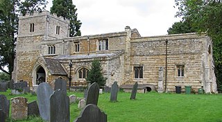
There are around 60 houses, St Nicholas Church and a village hall.

The village has a 3-acre (12,000 m2) lake, two minutes walk to the west, which primarily stocks roach, perch and pike.

Alongside the lake resides the cricket pitch. The cricket team was started in the mid-1980s, predominantly playing friendlies on a Sunday. The team at one point could field five sets of brothers, Daniel (now at Wokingham Cricket Club) and Oliver Reddyhough, David and John Reddyhough, Simon and Sam Smith (now Gumley Cricket Club), Charles and Robert Mathew and Shaun and Ashley Burbery.[ citation needed ]

The village holds an annual Beer Festival, over a weekend in mid-June. The Victorian village hall becomes The Rising Sun (the old village pub, The Sun Inn, closed some time ago), complete with pub sign, hand pumps and a variety of real ales, and ciders, including some from the local Welland Valley vineyard.

The village is now (2017) enabled for high speed ultrafast (over 100Mbit/s) broadband via Zippynet. [4]

Notable people

Thomas Reynolds (antiquarian)

Related Research Articles

Naseby Human settlement in England

Naseby is a village in West Northamptonshire, England. The population of the civil parish at the 2011 Census was 687.

Barwell Human settlement in England

Barwell is a civil parish and large village in Leicestershire, England, with a population of around 8,750 people, Increasing to 9,022 at the 2011 census, the name literally translates as "Stream of the Boar" and is said to originate from a boar that used to drink from the well near a brook in Barwell. It was originally known as Borewell, but later became "Barwell", the name in use today. The brook is now called the River Tweed, and is a tributary of the River Trent.

Waddesdon Human settlement in England

Waddesdon is a village in Buckinghamshire, England, 6 miles (10 km) west-north-west of Aylesbury on the A41 road. The centre of a civil parish, which also includes the hamlets of Eythrope and Wormstone, Waddesdon was an agricultural settlement with milling, silk weaving and lace making enterprises.

Fleet Marston Human settlement in England

Fleet Marston is a civil parish and deserted medieval village in the Aylesbury Vale district of Buckinghamshire, England, about 2.5 miles (4 km) northwest of the centre of Aylesbury. The parish measures about 2.5 miles (4 km) north – south, but east – west it is nowhere more than about 34 mile (1.2 km) wide. It is bounded to the southeast by the River Thame, to the east by a stream that joins the Thame, and to the west by field boundaries. It has an area of 934 acres (378 ha).

Chawton Human settlement in England

Chawton is a village and civil parish in the East Hampshire district of Hampshire, England. The village lies within the South Downs National Park and is famous as the home of Jane Austen for the last eight years of her life.

North Marston Human settlement in England

North Marston is a village and also a civil parish within Aylesbury Vale district in Buckinghamshire, England. It is located about three miles south of Winslow, and four miles north of Waddesdon.

Boughton, Northamptonshire Village in Northamptonshire, England

Boughton is a village and civil parish in West Northamptonshire, England. It is situated approximately 4 miles (6.4 km) from Northampton town centre along the A508 road between Northampton and Market Harborough.

Gretton, Northamptonshire Human settlement in England

Gretton is a village and civil parish in North Northamptonshire. It is in Rockingham Forest and overlooks the valley of the River Welland and the neighbouring county of Rutland. At the time of the 2001 census, the parish had a population of 1,240 people, increasing to 1,285 at the 2011 census.

Marston Moreteyne Human settlement in England

Marston Moreteyne is a large English village and civil parish located on the A421 between Bedford and Milton Keynes in the county of Bedfordshire. The population was 4,560 at the 2001 census, and 4,556 at the 2011 census. The village is served by Millbrook railway station, approximately a mile away on the Marston Vale Line.

Ormesby Suburb in Middlesbrough, North Yorkshire, England

Ormesby is a suburban village which is partly in the Borough of Middlesbrough & Borough of Redcar and Cleveland in North Yorkshire, England. It forms part of the Teesside built up area around Middlesbrough.

Chipperfield Human settlement in England

Chipperfield is a village and civil parish in the Dacorum district of Hertfordshire, England, approximately five miles southwest of Hemel Hempstead and five miles north of Watford. It stands on a chalk plateau at the edge of the Chiltern Hills, between 130 and 160 metres above sea level.

New Buckenham Human settlement in England

New Buckenham is a village and civil parish in the English county of Norfolk.

Fulking Human settlement in England

Fulking is a village and civil parish in the Mid Sussex District of West Sussex, England. The parish lies wholly with the South Downs National Park.

Lubenham

Lubenham is a small rural village and civil parish 2 miles (3.2 km) west of the market town of Market Harborough, in the Harborough district, in the south of Leicestershire, England. The first National Hunt Chase Challenge Cup was held in Lubenham, on the grounds of what is now Thorpe Lubenham Hall. Lubenham Parish extends to Gartree in the north and Bramfield Park in the west. The village appears in four entries in the Domesday Book.

Ockbrook Human settlement in England

Ockbrook is a village in Derbyshire, England. It is almost contiguous with the village of Borrowash, the two only separated by the A52. The civil parish is Ockbrook and Borrowash. The population of this civil parish at the 2011 Census was 7,335. Ockbrook lies about 5 miles (8.0 km) east of Derby.

Warnham Human settlement in England

Warnham is a village and civil parish in the Horsham district of West Sussex, England. The village is centred 2 miles (3.2 km) north-northwest of Horsham, 31 miles (50 km) from London, to the west of the A24 road. Other named settlements within the parish include the hamlets of Goosegreen, Kingsfold and Winterfold as well as parts of Strood Green and Rowhook. The area is in the northwest of the Weald, a gently sloped remnant forest in southeast England and largely a plain by erosion.

Claxton, Norfolk Human settlement in England

Claxton is a small village 8.5 miles (13.7 km) south-east of Norwich, and south of the River Yare, between Rockland St. Mary and Loddon in South Norfolk, England. In the 2001 census it contained 85 households and a population of 244, the population increasing to 291 at the 2011 census. Just to the south lie the small villages of Ashby St Mary and Carleton St Peter.

Thorpe Lubenham is a deserted settlement and former civil parish in the English midland county of Northamptonshire.

Marsh Baldon Human settlement in England

Marsh Baldon is a village and civil parish about 5 miles (8 km) southeast of Oxford in Oxfordshire. Since 2012 it has been part of the Baldons joint parish council area, sharing a parish council with the adjacent civil parish of Toot Baldon. The 2011 Census population is 310.

St Nicholas Church, Marston Trussell Church

St Nicholas's Church is an Anglican Church and the parish church of Marston Trussell. It is a Grade I listed building and stands on the south side of Lubenham Road at the eastern edge of the village.

References

  1. Office for National Statistics: Marston Trussell CP: Parish headcounts. Retrieved 14 November 2009
  2. "Civil Parish population 2011". Neighbourhood Statistics. Office for National Statistics. Retrieved 16 June 2016.
  3. "Key to English Place-names".
  4. Zippynet website