Brixworth

Last updated

Brixworth
Brixworth Church.jpg
Northamptonshire UK location map (2021).svg
Red pog.svg
Brixworth
Location within Northamptonshire
Population5,162 (2001 census) [1] 5,228 (2011 census)
OS grid reference SP7470
Civil parish
  • Brixworth
District
Shire county
Region
Country England
Sovereign state United Kingdom
Post town Northampton
Postcode district NN6
Dialling code 01604
Police Northamptonshire
Fire Northamptonshire
Ambulance East Midlands
UK Parliament
Website Brixworth Online
List of places
UK
England
Northamptonshire
52°19′44″N0°54′14″W / 52.329°N 0.904°W / 52.329; -0.904

Brixworth is a large village and civil parish in West Northamptonshire, England. The 2001 census recorded a parish population of 5,162, [1] increasing to 5,228 at the 2011 census. [2] The village's All Saints' Church is of Anglo-Saxon origin.

Contents

Location

The village is about 5 miles (8 km) north of Northampton next to the A508 road, which now by-passes the village. It is about 8 miles (13 km) south of Market Harborough. About 3 miles (5 km) north of the village is a junction with the A14 road that runs between the M1 and M6 motorway interchange at Catthorpe east to Cambridge and the east coast port of Felixstowe.

The village is popular with commuters to Leicester, Peterborough, Birmingham and London. The nearest railway stations for London are at Northampton, for London (Euston) (EUS), and Kettering for London (St Pancras) (STP) and for Leicester (LEI) at Market Harborough. Trains for Northampton also go to Coventry and Birmingham.

History

F1 engine made by Ilmor in Brixworth Mercedes-Benz FO110J engine.jpg
F1 engine made by Ilmor in Brixworth

The place-name 'Brixworth' is first attested in the Domesday Book of 1086, where it appears as Briclesworde. The name means 'Beorhtel's or Beorhthelm's homestead or enclosure'. [3]

A lengthy article about the history of the parish appears in the Victoria County History for Northamptonshire, volume 4, which was published in 1937. Its text can be consulted at British History Online. [4]

The main road from Northampton to Market Harborough passed through the village, where a number of inns served the needs of travellers for refreshment, lodging and a change of horses. The buildings of two present-day pubs in the village date back to the era of horse-drawn transport:

In 1819 Sir Charles Knightley purchased land between Spratton Road and Kennel Terrace, where the Pytchley Hunt then erected kennels, providing a fresh source of local employment at a time of agricultural depression. The Hunt remained in the village until 1966, after which the site was developed for housing.
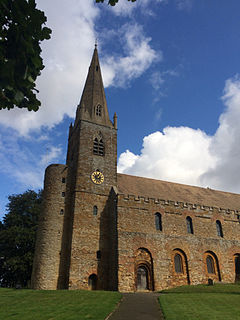
The church

All Saints' Church is one of the oldest, largest and most complete Anglo-Saxon churches in the country. It was founded circa 680 AD and was called "the finest Romanesque church north of the Alps" by Sir Alfred Clapham. [7]

Chartism

In June 1839, Brixworth was the scene of a notable public meeting addressed by the Chartist Robert George Gammage of Northampton. Before the meeting took place, Gammage and his two companions attended a service in the parish church where the vicar Charles Frederic Watkins rebuked them and threatened the three with arrest if the meeting proceeded. Despite this, Gammage recalled that attendance at the roadside assembly later that day amounted to several hundreds and Watkins' efforts to persuade the constable to arrest those who addressed it were unsuccessful. [8]

Poor Law Union

Brixworth Poor Law Union was established in 1835 and a workhouse erected on the south side of Spratton Road soon afterwards. Only the entrance block, including some later side extensions to it, remains; these premises are now used for business purposes. [9] The activities of the Brixworth Poor Law Union attracted controversy, particularly in the latter part of the 19th century, because of its reluctance to provide relief to poor people unless they agreed to enter the Workhouse. Brixworth is the focus of a substantial work on the political, social and personal implications of welfare policies during the period. [10] The Workhouse was closed in 1935.

The railway

The Northampton and Market Harborough railway through the parish was opened in 1859, passing 0.5 miles (800 m) west of the village. British Railways closed Brixworth railway station to passenger traffic in 1960 and closed the line to freight traffic in 1981. The trackbed of the former railway was reopened in 1993 as the Brampton Valley Way.

Iron ore quarrying

At various times iron ore quarrying has been carried out on the north, east and south sides of the village. The ore was taken in various ways to the railway for transport to ironworks. The first quarry can still be seen west of the church at a place called Stonepit Close. It is now allotments. Quarrying began in 1863 and finished about 1874. It is not clear if the ore was taken away by tramway or by horse and road wagon to the station. In about 1873 another quarry was opened nearby, to the north of the church. This was connected by 4 ft (1,219 mm) gauge tramway to sidings at the station. When this was worked out the same tramway served later quarries further east to the north and south of Scaldwell Road, finishing in 1936 south of Scaldwell Road and in 1947 further north. The later quarries in this system were to the east of the A508.

Another quarry began in 1873 to the south of the village connected with the railway by 4 ft (1,219 mm) gauge tramway. This was firstly to the west of the main road in the area to the south of Foxhill Crescent and later to the east of the main road in the vicinity of what is now Ashway. Quarrying finished here in about 1912.

A new pit was begun in 1939, operating until 1949. This was operated by the Staveley Coal and Iron Company and was connected to their quarrying operation at Scaldwell by an extension of their 3 ft (914 mm) gauge tramway. The ore was transported from Scaldwell to sidings near Hanging Houghton via an aerial ropeway. The aerial ropeway was replaced in 1954 by a standard gauge branch line. [11]

Another quarry began operation in 1880 west of Station Road, opposite Stonepit Close. It had its own tramway to the sidings at Brixworth Station and ceased operation in 1896.

The 4 ft (1,219 mm) gauge tramways were worked by horse at first but the first steam locomotive was in use by 1879. Quarrying was done by hand at first. The first steam quarrying machine was in use by 1917, and the first diesel machine in 1935. [11] Close to the south and east of the village most of the quarried area has had housing and an industrial estate built on it. In the industrial estate the street names Ironstone Way, Quarry Road, Ferro Fields and Staveley Way commemorate the quarries. Apart from Stonepit Close the visible remains of the quarrying are in the form of ground levels being below the roads and surrounding fields. The industrial estate and part of the churchyard are lower than the original landscape, due to the quarrying activity.

Village development

From the 1960s onwards, a large amount of new housing has been built at Brixworth, mainly on fields to the south of the original village. A by-pass on the east side has diverted traffic travelling between Northampton and Market Harborough away from the built-up area. Another major change has been the creation of Pitsford Water (a reservoir) and Brixworth Country Park, which are a short distance from the village. [12]

Notable buildings

The Historic England website contains details of a total of 17 listed buildings in the parish of Brixworth, all of which are Grade II apart from All Saints' Church, which is Grade I. [13] They include:

Brixworth Hall

Brixworth Hall from page 124 of volume 3 of "Views of the Seats of Noblemen and Gentlemen in England, Wales, Scotland and Ireland. Neale(1818) p3.124 - Brixworth Hall, Northamptonshire.jpg
Brixworth Hall from page 124 of volume 3 of "Views of the Seats of Noblemen and Gentlemen in England, Wales, Scotland and Ireland.

Brixworth Hall was near the church, surrounded by a park and close to the centre of the historic settlement of Brixworth. The hall was built in the Tudor period by the Saunders family who were part owners of the manor of Brixworth from 1532. [29] The house was owned by four generations of the Saunders family until the early 18th century. [30] It was extended in the 18th century, incorporating parts of the original building. [30] The house was offered for sale by auction in 1801 at which time it was described as being a spacious stone mansion with coach house, stabling, gardens, canals and fish-ponds. [31] The hall was demolished in 1954. [32]

Churches

The churches that currently worship at Brixworth are:

A Wesleyan Methodist (later Methodist) chapel was opened in Church Street in 1811 and enlarged in 1860. The chapel closed in the 1970s and the building is now in residential use. [33]

School

The primary school at Brixworth is Brixworth Church of England Voluntary Controlled Primary School. Details of a series of reports on the school can be found in the relevant section of the Ofsted website. [34] 450 pupils were on the roll at the time of the inspection in September 2011.

Clubs and amenities

Brixworth Juniors Football Club is a football club that encourages children of all ages to be active and play sport. It has produced successful footballers, including AFC Rushden & Diamonds' Liam Dolman and Derby County's Jack Marriot. The adults' team, Brixworth All Saints, are in Division One of the Northamptonshire Football Combination, which is at level 8 of the National League System. It plays its home games on the village's St David's Recreation Ground.

Brixworth Cricket Club plays on the ground at Haywards Barn, which was opened in 2008, as well as on St David's playing field for third team and junior games. The 1st team play in the premier division of the Northants Cricket League and the 2nd and 3rd team play in Divisions 5 and 13. They run 4 junior teams between ages 9 and 17 who play on both grounds.

The Drama Society stages 2–3 productions annually – including a pantomime.

The village is home to an award-winning historical re-enactment society, Sir William Harrington's Companye, who recreate life as it would have been for the 15th-century inhabitants of Brixworth.

There is a free village newspaper, the Brixworth Bulletin.

Brampton Valley Way passes 0.7 miles (1.1 km) west of the village, Pitsford Reservoir is about 1 mile (2 km) to the southeast and the Northampton & Lamport Railway is 2.7 miles (4 km) to the south at Pitsford and Brampton railway station.

Wind farm

In 2008, the Mercedes-Benz HighPerformanceEngines (HPP) premises in Brixworth planned to build two 127 m (417 ft) high wind turbines. Lancaster-based Wind Direct has submitted a planning application to Daventry District Council to install the two turbines and Mercedes-Benz HPP plans to use 92 per cent of the electricity generated, with the rest being exported to the National Grid. The plans [35] [36] are controversial with opposition from some, but not all local residents.

Notes

  1. 1 2 "Area selected: Daventry (Non-Metropolitan District)". Neighbourhood Statistics: Full Dataset View. Office for National Statistics . Retrieved 19 April 2011.br
  2. "Civil Parish population 2011". Neighbourhood Statistics. Office for National Statistics. Retrieved 29 June 2016.
  3. Eilert Ekwall, The Concise Oxford Dictionary of English Place-names, p.66.
  4. "Brixworth" . Retrieved 7 February 2013.
  5. "The George Inn Brixworth" . Retrieved 7 February 2013.
  6. "The Coach and Horses Brixworth" . Retrieved 7 February 2013.
  7. Clapham, 1930, page 33, cited in Blair, 1977, page 152
  8. Robert George Gammage. "Becoming a Chartist speaker, and first leaving Northampton in 1840". A Vision of Britain Through Time. Retrieved 16 September 2015.
  9. "Brixworth Poor Law Union" . Retrieved 13 February 2015.
  10. Hurren, Elizabeth T (2007). Protesting About Pauperism: Poverty, Politics and Poor Relief in Late-Victorian England, 1870-1900. Woodbridge: The Boydell Press. ISBN   978-0-86193-292-4.
  11. 1 2 Tonks, Eric (April 1989). The Ironstone Quarries of the Midlands Part 3: The Northampton Area. Cheltenham: Runpast Publishing. p. 167-183. ISBN   1-870-754-034.
  12. "Brixworth Country Park". Archived from the original on 16 February 2013. Retrieved 7 February 2013.
  13. "Historic England – The List" . Retrieved 5 October 2015.
  14. "Historic England – Church of St All Saints, Brixworth" . Retrieved 6 October 2015.
  15. "Historic England – Brixworth War Memorial" . Retrieved 6 October 2015.
  16. "Historic England – Coach & Horses" . Retrieved 6 October 2015.
  17. "Historic England – The Cross, Brixworth" . Retrieved 6 October 2015.
  18. "Historic England – Home Farmhouse" . Retrieved 6 October 2015.
  19. "Historic England – Mint Cottage" . Retrieved 6 October 2015.
  20. "Historic England – Steps Cottage" . Retrieved 6 October 2015.
  21. "Historic England – The Firs" . Retrieved 6 October 2015.
  22. "Historic England – The George Inn" . Retrieved 6 October 2015.
  23. "Historic England – The Granary" . Retrieved 6 October 2015.
  24. "Historic England – The Grange" . Retrieved 6 October 2015.
  25. "Historic England – The Lodge" . Retrieved 6 October 2015.
  26. "Historic England – The Manor House" . Retrieved 6 October 2015.
  27. "Historic England – The Old Vicarage" . Retrieved 6 October 2015.
  28. "Historic England – The Pound House" . Retrieved 6 October 2015.
  29. Towns and Villages around Northampton
  30. 1 2 Victoria County History
  31. Sale particulars
  32. England's Lost Heritage
  33. Brixworth History Society (1993). Brixworth Now & Then. Brixworth: Brixworth History Society. p. 3.
  34. "Brixworth Primary School". Ofsted. Retrieved 20 September 2015.
  35. "Northampton Chronicle & Echo: Fight to stop wind turbines, 3 November 2008" . Retrieved 3 November 2008.
  36. "Plan for wind turbines temporarily withdrawn, 14 November 2008" . Retrieved 14 November 2008.

Related Research Articles

<span class="mw-page-title-main">Welford, Northamptonshire</span> Human settlement in England

Welford is a village and civil parish in the West Northamptonshire unitary authority area of Northamptonshire, England, just south of the River Avon and the border with Leicestershire. At the 2011 Census, the population of the parish was 1,043.

<span class="mw-page-title-main">Arthingworth</span> Human settlement in England

Arthingworth is a civil parish and village in the West Northamptonshire area of the county of Northamptonshire, England. The population of the civil parish at the 2011 census was 238.

Scaldwell is a village and civil parish in the West, Northamptonshire, England.

<span class="mw-page-title-main">Pitsford</span> Village in Northamptonshire, England

Pitsford is a village and civil parish in West Northamptonshire in the United Kingdom. According to 2001 census, the parish's population was 636 people, increasing to 671 at the 2011 census.

<span class="mw-page-title-main">Lamport, Northamptonshire</span> Human settlement in England

Lamport is a village and civil parish in West Northamptonshire, England. The village is on the A508, about 8 miles (13 km) south of Market Harborough and 8 miles (13 km) north of Northampton. Nearby is Lamport Hall. At the time of the 2001 census, the parish's population was 207 people, including Hanging Houghton and increasing to 225 at the 2011 Census.

<span class="mw-page-title-main">Chapel Brampton</span> Human settlement in England

Chapel Brampton is a village and former civil parish now in the parish of Church with Chapel Brampton, in the West Northamptonshire district, in the ceremonial county of Northamptonshire, England. Together with nearby Church Brampton, it is known as The Bramptons. At the time of the 2001 census, Chapel Brampton parish's population was 470 people. On 1 April 2009 the parish was abolished and merged with Church Brampton to form "Church with Chapel Brampton".

<span class="mw-page-title-main">Kingsthorpe</span> Suburb in Northampton, England

Kingsthorpe is a suburb and civil parish of Northampton, England. It is situated to the north of Northampton town centre and is served by the A508 and A5199 roads which join at Kingsthorpe's centre. The 2011 Census recorded the population of the district council ward as 4,477.

<span class="mw-page-title-main">Finedon</span> Human settlement in England

Finedon is a town and civil parish in North Northamptonshire, England, with a population at the 2011 census of 4,309. In 1086 when the Domesday Book was completed, Finedon was a large royal manor, previously held by Queen Edith, wife of Edward the Confessor.

<span class="mw-page-title-main">Tilton on the Hill</span> Village in Leicestershire, England

Tilton on the Hill is a village and a former civil parish, now in the parish of Tilton on the Hill and Halstead in the Harborough district of Leicestershire. The population of the civil parish of Tilton on the Hill and Halstead at the 2011 census was 601. It lies 2 miles north of the A47, on the B6047 to Melton Mowbray. Halstead civil parish was merged with Tilton on 1 April 1935, while the deserted medieval village of Whatborough was merged in on 1 April 1994. Marefield remains a separate civil parish, but is part of the Tilton Electoral Ward. In 1931 the parish of Tilton had a population of 152. St Peter's Tilton, the Parish Church is in the parish of Halstead, as is the vicarage.

Earls Barton is a village and civil parish in Northamptonshire, notable for its Anglo-Saxon church and shoe-making heritage. The village is in North Northamptonshire and was previously in the Borough of Wellingborough until 2021. At the time of the 2011 census, the population was 5,387. Earls Barton is renowned for its remarkable Anglo-Saxon heritage.

<span class="mw-page-title-main">Blisworth</span> Human settlement in England

Blisworth is a village and civil parish in the West Northamptonshire, England. The West Coast Main Line, from London Euston to Manchester and Scotland, runs alongside the village partly hidden and partly on an embankment. The Grand Union Canal passes through the village and the north portal of the Blisworth tunnel is near Stoke Road.

<span class="mw-page-title-main">A508 road</span> Road in Leicestershire, Northamptonshire and Buckinghamshire

The A508 is a 50.961 kilometres (31.666 mi), A-class road for north–south journeys in central and south central England, forming the route from Market Harborough in Leicestershire, via Northampton, to Old Stratford in Northamptonshire, just outside Milton Keynes.

<span class="mw-page-title-main">Islip, Northamptonshire</span> Human settlement in England

Islip is a village and civil parish in North Northamptonshire, England. The village is just west of Thrapston and 7 miles (11 km) east of Kettering. The parish is bounded to the east by the River Nene and to the north by Harpurs Brook, a tributary of the Nene. The 2011 Census recorded the parish's population as 829 people.

<span class="mw-page-title-main">Gayton, Northamptonshire</span> Human settlement in England

Gayton is a rural village and civil parish in West Northamptonshire, England, 5 miles (8 km) south-west of Northampton town centre. The village is situated on a hill close to the larger villages of Bugbrooke, Milton Malsor and Blisworth, with a linked public footpath network. At the 2011 Census, the population of the parish was 544.

<span class="mw-page-title-main">Knipton</span> Human settlement in England

Knipton is a village and former civil parish, now in the parish of Belvoir, in the Melton district, in the county of Leicestershire, England. It lies about 6 miles (10 km) from the town of Grantham, just off the A607, and 10 miles (16 km) from Melton Mowbray. It borders the Duke of Rutland's estate at Belvoir Castle. Although the village is in Leicestershire, it has a Nottinghamshire postcode and a Lincolnshire (Grantham) STD code. In 1931 the parish had a population of 273. On 1 April 1936 the parish was abolished and merged with Belvoir.

Spratton railway station is a former railway station which served the village of Spratton in Northamptonshire, England.

<span class="mw-page-title-main">Northampton–Market Harborough line</span>

The Northampton–Market Harborough line is a closed railway line in England. It opened on 16 February 1859 and finally closed on 16 August 1981. The former trackbed is used by the Brampton Valley Way and part of the route has been re-opened as the Northampton & Lamport Railway.

<span class="mw-page-title-main">Easton Neston</span> Human settlement in England

Easton Neston is situated in south Northamptonshire, England. Though the village of Easton Neston which was inhabited until around 1500 is now gone, the parish retains the name. At the 2011 Census the population of the civil parish remained less than 100 and was included in the town of Towcester.

<span class="mw-page-title-main">All Saints' Church, Pitsford</span> Church in Northamptonshire, England

All Saints' Church is an Anglican Church and the parish church of Pitsford. It is a Grade II* listed building and stands on the west side of Church Lane on the northern edge of the village.

<span class="mw-page-title-main">St John the Baptist's Church, Boughton</span> Church

St John the Baptist's Church is an Anglican Church and the parish church of Boughton. It is a Grade II listed building and stands on the east side of Church Street.

References