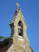
 Bellcote at St Edmund's Church, Wootton, Isle of Wight, England
 Bellcote at Stanford Road School, Prestonville, Brighton, England.
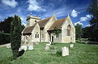
 Bellcote on the parish church of St Alban the Martyr, Charles Street, Cowley, Oxford.
 Bellcote on St Thomas' Church, Eaton, Cheshire.


Related Research Articles
Thomas Wright was an English antiquarian and writer.
Great and Little Kimble cum Marsh is a civil parish in central Buckinghamshire, England. It is located 5 miles (8 km) to the south of Aylesbury. The civil parish altogether holds the ancient ecclesiastical villages of Great Kimble, Little Kimble, Kimblewick and Marsh, and an area within Great Kimble called Smokey Row. The two separate parishes with the same name were amalgamated in 1885, but kept their separate churches, St Nicholas for Great Kimble on one part of the hillside and All Saints for Little Kimble on other side at the foot of the hill.

Aston Abbotts or Aston Abbots is a village and civil parish in Buckinghamshire, England. It is about 4 miles (6.4 km) north of Aylesbury and 2.5 miles (4 km) south-west of Wing. The parish includes the hamlet of Burston and had a population of 426 at the 2021 Census.
Sir John Edwin Sandys was an English classical scholar.

Woodstock is a market town and civil parish, 8 miles (13 km) north-west of Oxford in West Oxfordshire in the county of Oxfordshire, England. The 2011 Census recorded a parish population of 3,100.
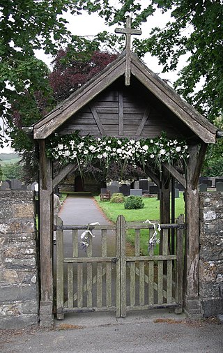
A lychgate, also spelled lichgate, lycugate, lyke-gate or as two separate words lych gate,, also wych gate, is a gateway covered with a roof found at the entrance to a traditional English or English-style churchyard. The name resurrection gate is also used. Examples exist also outside the British Isles in places such as Newfoundland, the Upland South and Texas in the United States, Australia, New Zealand, South Africa, Norway, and Sweden.

Mildenhall is a village and civil parish in the Kennet Valley in Wiltshire, England, immediately east of the market town of Marlborough. The village is about 1.5 miles (2 km) east of the centre of Marlborough, on the minor road which follows the River Kennet towards Ramsbury. The parish also contains the hamlets of Poulton and Stitchcombe. The name has often been written as Minal, and this is continued in the present-day pronunciation.

Hucclecote is a suburb in Gloucestershire, United Kingdom, comprising a ward in the City of Gloucester. It is located on the periphery of the city, between Barnwood and Brockworth, along Ermin Way, an old Roman road connecting Gloucester with Cirencester and the Cotswolds.

Hook Norton is a village and civil parish in Oxfordshire, England. It lies 4+1⁄2 miles (7 km) northeast of Chipping Norton, close to the Cotswold Hills. The 2011 Census recorded the parish's population as 2,117. The village is formed of four neighbourhoods: East End, Scotland End, Down End and Southrop.
The Complete Peerage is a comprehensive and magisterial work on the titled aristocracy of the British Isles.
Swalcliffe is a village and civil parish about 5 miles (8 km) west of Banbury in Oxfordshire. The parish is about 2+1⁄2 miles (4 km) long north–south and about 1 mile (1.6 km) east–west. The 2011 Census recorded the population of the modern Swalcliffe parish as 210. The toponym "Swalcliffe" comes from the Old English swealwe and clif, meaning a slope or cliff frequented by swallows. The ancient parish of Swalcliffe was larger than the present civil parish, and included the townships of Epwell, Shutford, Sibford Ferris and Sibford Gower.

Gropecunt Lane was a street name found in English towns and cities during the Middle Ages, believed to be a reference to the prostitution centred on those areas; it was normal practice for a medieval street name to reflect the street's function or the economic activity taking place within it. Gropecunt, the earliest known use of which is in about 1230, appears to have been derived as a compound of the words grope and cunt. Streets with that name were often in the busiest parts of medieval towns and cities, and at least one appears to have been an important thoroughfare.
John James Stewart Perowne was an English Anglican bishop. Born in Burdwan, Bengal, Perowne was a member of a notable clerical family, whose origins were Huguenot.

The bishop of London is the ordinary of the Church of England's Diocese of London in the Province of Canterbury. By custom the Bishop is also Dean of the Chapel Royal since 1723.

Yarnton is a village and civil parish in Oxfordshire about 1 mile (1.6 km) southwest of Kidlington and 4 miles (6 km) northwest of Oxford. The 2011 Census recorded the parish's population as 2,545.
Stadhampton is a village and civil parish about 7 miles southeast of Oxford in South Oxfordshire, England. Stadhampton is close to the River Thame, a tributary of the River Thames. The village was first mentioned by name in 1146, and was in the ownership of the bishops of Lincoln, the crown, and various Oxford colleges for most of subsequent history. The village includes several buildings of historical and architectural interest, including a parish church with features dating back to the 12th-century.
Seaxwulf was the founding abbot of the Mercian monastery of Medeshamstede, and an early medieval bishop of Mercia. Very little is known of him beyond these details, drawn from sources such as Bede's Ecclesiastical History. Some further information was written down in the 12th century at Peterborough Abbey, as Medeshamstede was known by that time. This suggests that he began his career as a nobleman, and that he may have had royal connections outside Mercia.

Brailes is a civil parish about 3 miles (5 km) east of Shipston-on-Stour in Warwickshire, England. It includes the two villages of Lower and Upper Brailes but is often referred to as one village as the two adjoin each other. The parish includes the village of Winderton about 1.5 miles (2.4 km) northeast of Brailes, and the deserted medieval village of Chelmscote about 3.5 miles (5.6 km) north of Brailes. The parish is bounded to the east by Ditchedge Lane and Beggars' Lane, which are a historic ridgeway that also forms part of the county boundary with Oxfordshire. The northeastern boundary is a minor road, part of which follows the course of a Roman road.
Kyneburga, Kyneswide and Tibba were female members of the Mercian royal family in 7th century England who were venerated as saints.

Wilcote is a hamlet about 3+1⁄2 miles (5.6 km) north of Witney in Oxfordshire, England.
References
- ↑ "bell (IV.11.a)". Oxford English Dictionary . Vol. 2 (2nd ed.). Oxford University Press. 1989. p. 88.
- ↑ "cote". Oxford English Dictionary . Vol. 3 (2nd ed.). Oxford University Press. 1989. p. 994.
This article about the architecture of churches or other Christian places of worship is a stub. You can help Wikipedia by expanding it. |