St Sepulchre (parish)

Last updated

St Sepulchre was an ancient parish which had its southern part within the boundaries of the City of London and its northern part outside. Its former area is now within the contemporary neighbourhoods of Smithfield, Farringdon and Clerkenwell.

Contents

This meant for civil uses (foremost of which are the charitable works led by its priest or its patron then from the Tudor reforms its vestry, then for some decades after secularist reforms, the waning system of civil parishes) it was divided into:

The ecclesiastical version today covers essentially the same land plus an extension to the south-east. It has one designated church, which is referred to as Holy Sepulchre London.

St Sepulchre-without-Newgate Church, in the City of London. The church is just to the west of the former Newgate, literally a new gate in the city wall and which served the national arterial road to and via Oxford. Tower of St Sepulchre-without-Newgate Church.jpg
St Sepulchre-without-Newgate Church, in the City of London. The church is just to the west of the former Newgate, literally a new gate in the city wall and which served the national arterial road to and via Oxford.
St Sepulchre Middlesex as part of the short-lived Holborn District (Metropolis), shown in green St Giles & Holborn Civil Parish Map 1870.png
St Sepulchre Middlesex as part of the short-lived Holborn District (Metropolis), shown in green
The extramural City parish of St Sepulchre without Newgate, in the west of the City of London City of London civil parishes Map 1870.png
The extramural City parish of St Sepulchre without Newgate, in the west of the City of London

Divided parish

The church of St Sepulchre-without-Newgate was established, probably in the early 1100s, [1] immediately to the west of Newgate, one of the gates in London's Wall.

For civil purposes it was divided into two civil parishes, each called St Sepulchre, [2] although the parish in the City of London was also known as St Sepulchre without Newgate. [3] [4]

The Fleet, a sewer covered by Farringdon Street and Farringdon Road, formed the western limit of all, with Holborn on the western bank.

An established division

The number of parishes in England grew as more churches were built, especially in the 11th and 12th centuries, leading to the sub-division of parishes, this process ended when the introduction of Canon Law, around 1180, [5] made the sub-division of parishes, or even boundary changes, an onerous and infrequent event. At this point parishes took a settled form.

The extension of the authority of the City beyond the walls took place long before the Norman Conquest and long before the extramural area was settled to any significant degree. The City Wards were also taking shape before the Norman Conquest. [6] The parish of St Sepulchre has therefore probably always been split into its City and northern divisions.

The northern boundary of the City in this area, and therefore the dividing line between the two parishes of St Sepulchre, was initially formed in part by the now culverted Fagswell Brook [7] and once marked by boundary markers known as West Smithfield Bars which were in place by 1170. [8] The City’s warped local limit, partially covered by Smithfield Market, has been rationalised to follow Charterhouse Street.

St Sepulchre without Newgate

The civil parish of St Sepulchre without Newgate was part of the Farringdon Without Ward of the City of London.

It remained part of the ecclesiastic parish after 1547 but the rest rejoined recently, as the church reduced down to the initial church, Holy Sepulchre, only. The ecclesiastical (Church of England) parish has all the names, reflecting this division then re-merger: St. Sepulchre with Christ Church Greyfriars and St. Leonard Foster Lane [9]

St Sepulchre Middlesex

The civil parish of St Sepulchre Middlesex was part of the Ossulstone Hundred, and later the Finsbury Division, of Middlesex. The two civil parishes were united for ecclesiastical (church) purposes until 1547, [10] when the Middlesex part was split off and merged with other areas to form a new separate new ecclesiastical parish.

The daughter ecclesiastical parish has been re-merged (into its parent). This area, has, since the 19th century, been generally viewed as part of Clerkenwell, [11] though it has never been part of any Clerkenwell administrative or ecclesiastical unit. From 1547 St Sepulchre Middlesex broke off to become, for ecclesiastic purposes, a daughter ecclesiastical parish since when it has been re-merged. This area, has, since the 19th century, been generally viewed as part of Clerkenwell, [11] though it has never been part of any Clerkenwell administrative or ecclesiastical unit.

In 1900 it became part of the Metropolitan Borough of Finsbury, and in 1965 part of the London Borough of Islington.

End of the civil parish and the successor ecclesiastically

The civil parish in the City of London was abolished in 1907, with the civil parish in what is now the London Borough of Islington following in 1915.

The ecclesiastical parish, for a few centuries limited to the City from 1547, saw merger in 1954 with two small parishes to the south-east. It became the successor of about 95% of the original land, plus this extension, as St Sepulchre with Christ Church, Greyfriars and St Leonard, Foster Lane. [12] It has one church, which is known as Holy Sepulchre London. [9] The very slight loss of parish land affects a strip leading towards and particularly a parcel close to Barbican tube station. Parishioners are, however, today free to worship wherever they wish. The church has had a low church (protestant) liturgy since the Marian persecutions saw the execution of its vicar in 1555 and is the largest church (non-cathedral) in the City of London.

Population

St Sepulchre, City of London
Year1871188118911901
Population3,7012,1661,7541,160
St Sepulchre, Middlesex
Year18711881189119011911
Population2,8882,3921,9721,5031,192

Related Research Articles

<span class="mw-page-title-main">London Borough of Islington</span> London borough in United Kingdom

The London Borough of Islington is a London borough which forms part of Inner London, England. Islington has an estimated population of 215,667. It was formed in 1965, under the London Government Act 1963, by the amalgamation of the metropolitan boroughs of Islington and Finsbury.

<span class="mw-page-title-main">Clerkenwell</span> Area of central London

Clerkenwell is an area of central London, England.

<span class="mw-page-title-main">Finsbury</span> District of Central London

Finsbury is a district of Central London, forming the southeastern part of the London Borough of Islington. It borders the City of London.

<span class="mw-page-title-main">Holborn</span> Human settlement in England

Holborn is an area in London, England and is located in the London Borough of Camden and the City of London. It is in Central London and part of the West End. Holborn is apart of the Ward of Farringdon Without.

<span class="mw-page-title-main">River Fleet</span> Subterranean river in London, England

The River Fleet is the largest of London's subterranean rivers, all of which today contain foul water for treatment. It has been used as a sewer since the development of Joseph Bazalgette's London sewer system in the mid-19th century with the water being treated at Beckton Sewage Treatment Works. Its headwaters are two streams on Hampstead Heath, each of which was dammed into a series of ponds—the Hampstead Ponds and the Highgate Ponds—in the 18th century. At the southern edge of Hampstead Heath these descend underground as sewers and join in Camden Town. The waters flow 4 miles (6 km) from the ponds.

<span class="mw-page-title-main">Smithfield, London</span> Human settlement in England

Smithfield, properly known as West Smithfield, is a district located in Central London, part of Farringdon Without, the most westerly ward of the City of London, England.

Farringdon is an area in London and is located in the London Borough of Islington. It lies just north of the border with the City of London in Central London and close to Holborn. The term is used to describe the area around Farringdon station.

<span class="mw-page-title-main">Metropolitan Borough of Finsbury</span>

The Metropolitan Borough of Finsbury was a metropolitan borough within the County of London from 1900 to 1965, when it was amalgamated with the Metropolitan Borough of Islington to form the London Borough of Islington.

<span class="mw-page-title-main">Christ Church Greyfriars</span> Church in the City of London, United Kingdom

Christ Church Greyfriars, also known as Christ Church Newgate Street, was a church in Newgate Street, opposite St Paul's Cathedral in the City of London. Established as a monastic church in the thirteenth century, it became a parish church after the Dissolution of the Monasteries. Following its destruction in the Great Fire of London of 1666, it was rebuilt to the designs of Sir Christopher Wren. Except for the tower, the church was largely destroyed by bombing during the Second World War. The decision was made not to rebuild the church; the ruins are now a public garden.

<span class="mw-page-title-main">St Luke's, London</span> Human settlement in England

St Luke's is an area in London, England and is located in the London Borough of Islington. It lies just north of the border with the City of London near the Barbican Estate, and the Clerkenwell and Shoreditch areas.

Hornsey was an ancient parish in the county of Middlesex. It was both a civil parish, used for administrative purposes, and an ecclesiastical parish of the Church of England.

The Finsbury Division was one of four divisions of the Hundred of Ossulstone, in the historic county of Middlesex, England. The area of the Finsbury Division is now the core of modern north London. The other divisions were named Holborn, Kensington and Tower. Ossulstone hundred was divided in the seventeenth century, with each of the four divisions replacing the hundred for most administrative purposes.

The parliamentary borough of Finsbury was a constituency of the House of Commons of the UK Parliament from 1832 to 1885, and from 1918 to 1950. The constituency was first created in 1832 as one of seven two-seat "metropolis" parliamentary boroughs other than the two which already existed: Westminster and the City of London; the latter until 1885 retained an exceptional four seats. Finsbury was directly north of the City of London and was smaller than the Finsbury division of the Ossulstone hundred but took in land of Holborn division to its southwest in pre-introduction changes by Boundary Commissioners. It included Finsbury, Holborn, Moorfields, Clerkenwell, Islington, Stoke Newington and historic St Pancras. The 1918 constituency corresponded to the smaller Metropolitan Borough of Finsbury ; it was a seat, thus electing a single member, fulfilling a longstanding aim of Chartism which underscored the 1832 reforms.

<span class="mw-page-title-main">Farringdon Without</span> Ward of the City of London

Farringdon Without is the most westerly ward of the City of London, England. Its suffix Without reflects its origin as lying beyond the City's former defensive walls. It was first established in 1394 to administer the suburbs west of Ludgate and Newgate, including West Smithfield and Temple. This was achieved by splitting the very large, pre-existing Farringdon Ward into two parts, Farringdon Within and Farringdon Without. The large and prosperous extramural suburb of Farringdon Without has been described as having been London's first West End.

<span class="mw-page-title-main">Charterhouse Square</span> Garden square in Farringdon in the London Borough of Islington

Charterhouse Square is a garden square, a pentagonal space, in Farringdon, in the London Borough of Islington, and close to the former Smithfield Meat Market. The square is the largest courtyard or yard associated with the London Charterhouse, mostly formed of Tudor and Stuart architecture restored after the London Blitz. The square adjoins other buildings including a small school. It lies between Charterhouse Street, Carthusian Street and the main Charterhouse complex of buildings south of Clerkenwell Road. The complex includes a Chapel, Tudor Great Hall, Great Chamber, the Barts and The London School of Medicine and Dentistry and a 40-resident almshouse.

<span class="mw-page-title-main">St George in the East (parish)</span>

St George in the East, historically known as Wapping-Stepney, was an ancient parish, in the London Borough of Tower Hamlets, England. The place name is no longer widely used.

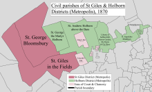
St Andrew Holborn was an ancient English parish that until 1767 was partly in the City of London and mainly in the county of Middlesex. Its City, thus southern, part retained its former name or was sometimes officially referred to as St Andrew Holborn Below the Bars.

<span class="mw-page-title-main">Angel, London</span> Human settlement in England

The Angel is an area on the northern fringes of Central London within the London Borough of Islington. It is 2 miles (3.2 km) north-northeast of Charing Cross on the Inner Ring Road at a busy transport intersection. The area is identified in the London Plan as one of 35 major centres in London. It is a significant commercial and retail centre, and a business improvement district. The Angel straddles the ancient boundary of the parishes of Clerkenwell and Islington that later became the metropolitan boroughs of Finsbury and Islington. It is named from the former Angel Inn which stood on the corner of Islington High Street and Pentonville Road. Since 1965 the whole area has formed part of the London Borough of Islington in Greater London.

<span class="mw-page-title-main">Glasshouse Yard</span>

The Liberty of Glasshouse Yard was an extra-parochial liberty adjacent to the City of London. The liberty took its name from a glass manufacturing works established there. The area now forms part of the London Borough of Islington.

References

  1. "London, 800-1216". Brooke and Keir, p144
  2. Youngs, Frederic (1979). Guide to the Local Administrative Units of England. Vol. I: Southern England. London: Royal Historical Society. ISBN   0-901050-67-9.
  3. Great Britain Historical GIS / University of Portsmouth, St Sepulchre (City of London) . Retrieved 9 September 2010.
  4. Great Britain Historical GIS / University of Portsmouth, St Sepulchre (Middlesex) . Retrieved 9 September 2010.
  5. History of the Countryside by Oliver Rackham, 1986 p19
  6. Process, terms and sources described in detail in "London, 800-1216". Brooke and Keir, Chapter 7
  7. From a map based on Stow c 1600, (discussed in "Street-names of the City of London", (1954) by Eilert Ekwall) shows the "Fagswell Brook" south of Cowcross Street as the northern boundary of the City)
  8. 'St John Street: Introduction; west side', in Survey of London: Volume 46, South and East Clerkenwell, ed. Philip Temple (London, 2008), pp. 203-221. British History Online http://www.british-history.ac.uk/survey-london/vol46/pp203-221 [accessed 24 October 2020].
  9. 1 2 Parish map of Holy Sepulchre London Church of England
  10. Youngs, Frederic (1979). Guide to the Local Administrative Units of England. I: Southern England. London: Royal Historical Society. ISBN   0-901050-67-9 p304
  11. 1 2 'Introduction', in Survey of London: Volume 46, South and East Clerkenwell, ed. Philip Temple (London, 2008), pp. 3-27. British History Online http://www.british-history.ac.uk/survey-london/vol46/pp3-27 [accessed 24 October 2020].
  12. Youngs p 303

51°31′N0°6′W / 51.517°N 0.100°W / 51.517; -0.100