Stadl an der Mur | |
|---|---|
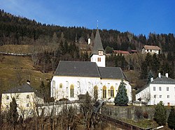 Stadl an der Mur parish church | |
 Coat of arms | |
 Stadl an der Mur Location within Austria | |
| Coordinates: 47°05′00″N13°58′00″E / 47.08333°N 13.96667°E | |
| Country | Austria |
| State | Styria |
| District | Murau |
| Area | |
• Total | 106.73 km2 (41.21 sq mi) |
| Elevation | 884 m (2,900 ft) |
| Population (1 January 2016) [1] | |
• Total | 968 |
| • Density | 9.1/km2 (23/sq mi) |
| Time zone | UTC+1 (CET) |
| • Summer (DST) | UTC+2 (CEST) |
| Postal code | 8862 |
| Area code | 03534 |
| Vehicle registration | MU |
Stadl an der Mur is a former municipality in the district of Murau in the Austrian state of Styria. Since the 2015 Styria municipal structural reform, it is part of the municipality Stadl-Predlitz. [2]