The Neva is a river in northwestern Russia flowing from Lake Ladoga through the western part of Leningrad Oblast to the Neva Bay of the Gulf of Finland. Despite its modest length of 74 kilometres (46 mi), it is the fourth-largest river in Europe in terms of average discharge.

The geography of Switzerland features a mountainous and landlocked country located in Western and Central Europe. Switzerland's natural landscape is marked by its numerous lakes and mountains. It is surrounded by five countries: Austria and Liechtenstein to the east, France to the west, Italy to the south and Germany to the north. Switzerland has a maximum north–south length of 220 kilometres (140 mi) and an east–west length of about 350 kilometres (220 mi).

Zealand at 7,031 km2 is the largest and most populous island in Denmark proper. Zealand had a population of 2,319,705 on 1 January 2020, comprising 40% of the country's population.

Lake Constance refers to three bodies of water on the Rhine at the northern foot of the Alps: Upper Lake Constance (Obersee), Lower Lake Constance (Untersee), and a connecting stretch of the Rhine, called the Lake Rhine (Seerhein). These waterbodies lie within the Lake Constance Basin in the Alpine Foreland through which the Rhine flows. The nearby Mindelsee is not considered part of Lake Constance.
Friedrich Wilhelm Murnau was a German film director, producer and screenwriter. He is regarded as one of cinema's most influential filmmakers for his work in the silent era.

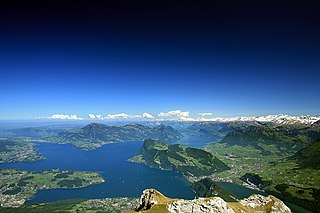
Lake Geneva is a deep lake on the north side of the Alps, shared between Switzerland and France. It is one of the largest lakes in Western Europe and the largest on the course of the Rhône. Sixty percent of the lake belongs to Switzerland and forty percent to France.
Lake Lucerne is a lake in central Switzerland and the fourth largest in the country.

The Zugspitze, at 2,962 m (9,718 ft) above sea level, is the highest peak of the Wetterstein Mountains and the highest mountain in Germany. It lies south of the town of Garmisch-Partenkirchen in Bavaria, and the Austria–Germany border is on its western summit. South of the mountain is the Zugspitzplatt, a high karst plateau with numerous caves. On the flanks of the Zugspitze are two glaciers, the largest in Germany: the Northern Schneeferner with an area of 30.7 hectares and Höllentalferner with an area of 24.7 hectares. Shrinking of the Southern Schneeferner led to the loss of glacier status in 2022.

Lake Neuchâtel is a lake primarily in Romandy, the French-speaking part of Switzerland. The lake lies mainly in the canton of Neuchâtel, but is also shared by the cantons of Vaud, Fribourg, and Bern. It comprises one of the lakes in the Three Lakes Region, along with lakes Biel/Bienne and Morat/Murten.

Lake Onega is a lake in northwestern Russia, on the territory of the Republic of Karelia, Leningrad Oblast and Vologda Oblast. It belongs to the basin of the Baltic Sea, and is the second-largest lake in Europe after Lake Ladoga, slightly smaller than Lebanon. The lake is fed by about 50 rivers and is drained by the Svir.

Lake Brienz is a lake just north of the Alps, in the canton of Bern in Switzerland. It has a length of about 14 kilometres (8.7 mi), a width of 2.8 kilometres (1.7 mi) and a maximum depth of 260 metres (850 ft). Its area is 29.8 square kilometres (11.5 sq mi); the surface is 564 metres (1,850 ft) above the sea-level. It is fed, among others, by the upper reaches of the Aare at its eastern end, the Giessbach at its southern shore from steep, forested and rocky hills of the high Faulhorn and Schwarzhoren more than 2,000 metres (6,600 ft) above the lake, as well as by both headwaters of the Lütschine, the Schwarze Lütschine flowing from Grindelwald, and the Weisse Lütschine from the Lauterbrunnen Valley, at its southwestern corner. Not far north from Lütschine's inflow, the lake drains into a further stretch of the Aare at its western end. The culminating point of the lake's drainage basin is the Finsteraarhorn at 4,274 metres above sea level.

Murnau am Staffelsee is a market town in the district of Garmisch-Partenkirchen, in the Oberbayern region of Bavaria, Germany.

Seehausen is a town in the district of Stendal, in Saxony-Anhalt, Germany. It is situated approximately 30 km (19 mi) north of Stendal in the Altmark, a historic region in Germany, comprising the northern third of Saxony-Anhalt. In January 2010 it absorbed the former municipalities Beuster, Geestgottberg and Losenrade, and in September 2010 Schönberg.

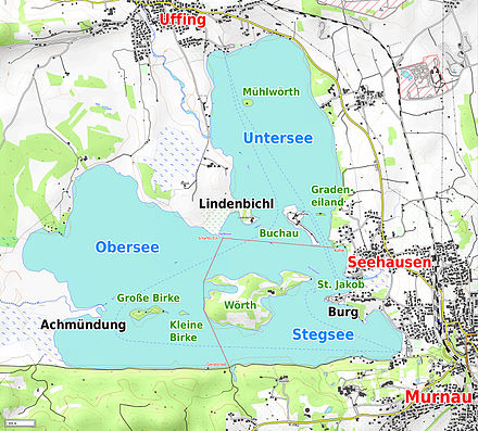
Uffing am Staffelsee is a municipality in the district of Garmisch-Partenkirchen, in Bavaria, Germany. It consists of the two villages of Uffing and Schöffau and is located on Staffelsee, the warmest lake in Germany. The River Ach flows through Uffing.

Bad Kohlgrub is a German municipality in the district of Garmisch-Partenkirchen, in Bavaria. It lies 12 kilometres (7.5 mi) west of Murnau am Staffelsee and 8 kilometres (5.0 mi) north of Oberammergau, and is connected to both by the Ammergau Railway.

Seehausen am Staffelsee is a municipality in the district of Garmisch-Partenkirchen, in Bavaria, Germany. The main village, Seehausen, lies on the eastern shore of the Staffelsee lake.

The Munich–Garmisch-Partenkirchen railway is a single track, electrified main line railway in the southern part of the German state of Bavaria. It runs from Munich via Starnberg and Murnau to Garmisch-Partenkirchen. The first part of it was opened in 1854 and is one of the oldest lines in Germany.

The Upper and Lower Eissee are two lakes in the Dachstein Mountains in the Austrian state of Upper Austria. They lie north of a 2,794 metres (9,167 ft) high mountain, the Gjaidstein, at an elevation of around 2,000 metres (6,600 ft).

The Werdenfelser Land is a region of Upper Bavaria that extends from Mittenwald in the south to Farchant. It includes parts of the Bavarian Alps. From the Middle Ages until the Thirty Years' War, the Werdenfelser Land was subject to the Prince-Bishop of Freising, not the Duke of Bavaria.
Schwanau is an island in Lake Lauerz, located in the canton of Schwyz in Central Switzerland. It is occupied by a ruined castle, the Burgruine Schwanau, a chapel and a restaurant. Administratively the island lies within the municipality of Lauerz, but it is owned by the canton of Schwyz.