Stanhope Town Hall

Last updated

Stanhope Town Hall
Stanhope Town Hall (geograph 7287268).jpg
The building in 2022
LocationFront Street, Stanhope
Coordinates 54°44′56″N2°00′37″W / 54.7489°N 2.0104°W / 54.7489; -2.0104
Built1849
Architectural style(s) Victorian style
Durham UK location map.svg
Red pog.svg
Shown in County Durham

Stanhope Town Hall is a former municipal building on Front Street, Stanhope, a town in County Durham, England. The building is not currently in use and is being marketed for sale.

History

In 1846, the parish leaders in Stanhope, led by the Rector, the Reverend William Darnell, decided to commission a town hall for the parish and to finance it by public subscription. The site they selected, on the north side of Front Street in the west end of the town, was held in copyhold by the Diocese of Durham, and the Bishop of Durham, Edward Maltby, donated it to the parish. [1]

The new building was designed in the Victorian style, built in rubble masonry and was completed in 1849. The design involved a main block of five bays facing onto Front Street. It was fenestrated by a mixture of bi-partite and tri-partite mullioned windows on the ground floor and by five cross-windows on the first floor. After the grant of some more land by the Ecclesiastical Commissioners, the building was enlarged, to accommodate a police station and a magistrates' court, in 1862. [2]

Following significant population growth, largely associated with the status of Stanhope as a market town, a local board of health was established in the town in February 1874. [3] The board was succeeded by an urban district in 1894. In this context the new council decided to alter the town hall. The alterations created a canted entrance bay on the corner of Front Street and Cross Street. The new bay contained a segmental headed doorway on the ground floor and a cross-window on the first floor, and was surmounted by a semi-circular pediment containing a date stone inscribed with the year, 1901, in the tympanum. [4]

A new building to accommodate the local police station was erected further northwest along Front Street in the early 20th century. The Durham Constabulary relocated to the new building at that time, allowing the original building to be dedicated to municipal use. [5] The new building served as a police station for over a century but, after the police service moved to the Durham Dales Centre in Castle Gardens in March 2008, [6] it was converted into a community centre; a local community association acquired it in September 2020. [7]

Meanwhile, the original building, which by 1901 had a sign saying "Stanhope Town Hall" over the doorway, continued to serve as the main municipal centre. Internally, the principal room was the assembly hall on the first floor, which was 43 feet (13 m) long and 41 feet (12 m) wide; [8] it was regularly used for hosting dances and other functions. [9] [10] [11]

During the First World War, the building was made available to the ladies nursing brigade in case of an air raid. [12] It was also used as a recruiting station for the new armies by the Durham Light Infantry. [13] A plaque, to commemorate the lives of local service personnel who had died in the war was unveiled opposite the main entrance of the town hall on 23 December 1921. [14] [15]

The town hall ceased to be the local seat of government when the enlarged Weardale Rural District Council was formed at Fairfield House in Stanhope in 1937. [16] It was subsequently under-used and part of it was operating as the West End Co-operative Stores by the late 1980s. [5] In July 2019, Durham County Council decided it was surplus to requirements, [17] and it was placed on the market in November 2019. [18] The local member of parliament and future Chairman of the Conservative Party, Richard Holden, began to use it as a venue for his constituency surgeries shortly after being elected in December 2019. [19] It remained unsold by late 2021, at which time the building was described as an "eyesore", although the council stated that it had some plans for investment. [20]

Related Research Articles

<span class="mw-page-title-main">Bishop Auckland</span> Town and civil parish in County Durham, England

Bishop Auckland is a market town and civil parish at the confluence of the River Wear and the River Gaunless in County Durham, England. It is 12 miles (19 km) northwest of Darlington and 12 miles (19 km) southwest of Durham.

<span class="mw-page-title-main">Weardale Railway</span> Heritage railway in County Durham, England

The Weardale Railway is an independently owned British single-track branch line heritage railway between Bishop Auckland, Witton-le-Wear, Wolsingham, Frosterley and Stanhope. Weardale Railway began services on 23 May 2010, but decided to run special trains rather than a scheduled service for the 2013 season. The line was purchased by the Auckland Project in 2020 with a view to restarting passenger services. In 2021, a bid was submitted to the Restoring Your Railway fund. In October 2021, the Department for Transport allocated funding for the development of a business case.

<span class="mw-page-title-main">St John's Chapel, County Durham</span> Human settlement in England

St John's Chapel is a village in the civil parish of Stanhope, in County Durham, England. It is situated in Weardale, on the south side of the River Wear on the A689 road between Daddry Shield and Ireshopeburn. The 2001 census reported a population of 307.

Wolsingham is a market town in Weardale, County Durham, England. It is situated by the River Wear, between Crook and Stanhope.

<span class="mw-page-title-main">Frosterley</span> Human settlement in England

Frosterley is a village in the civil parish of Stanhope, in County Durham, England. It is situated in Weardale, on the River Wear close to its confluence with Bollihope Burn; between Wolsingham and Stanhope; 18 miles (29 km) west of Durham City and 26 miles (42 km) southwest of Newcastle upon Tyne. In the 2001 census Frosterley had a population of 705.

<span class="mw-page-title-main">Stanhope, County Durham</span> Town in County Durham, England

Stanhope is a market town and civil parish in the County Durham district, in the ceremonial county of Durham, England. It lies on the River Wear between Eastgate and Frosterley, in the north-east of Weardale. The main A689 road over the Pennines is crossed by the B6278 between Barnard Castle and Shotley Bridge. In 2001 Stanhope had a population of 1,633, in 2019 an estimate of 1,627, and a figure of 1,602 in the 2011 census for the ONS built-up-area which includes Crawleyside. In 2011 the parish population was 4,581.

<span class="mw-page-title-main">Westgate, County Durham</span> Human settlement in England

Westgate is a village in the civil parish of Stanhope, in County Durham, England. It is situated in Weardale between St John's Chapel and Eastgate. In the 2001 census Westgate had a population of 298. Westgate is also the entrance to Slitt wood and an old abandoned lead mine. Other features of the village include a caravan site and a football and basketball court.

<span class="mw-page-title-main">Bishop Auckland railway station</span> Railway station in County Durham, England

Bishop Auckland is a railway station that serves the market town of Bishop Auckland in County Durham, North East England, 11 miles 77 chains (19.3 km) north-west of Darlington. The station is the Western terminus of the Tees Valley Line, which links it to Saltburn via Darlington. It is owned by Network Rail and managed by Northern Trains.

<span class="mw-page-title-main">Eastgate railway station</span> Disused railway station in Eastgate, County Durham

Eastgate railway station, also known as Eastgate-in-Weardale, served the village of Eastgate in County Durham, North East England from 1895 to 1953 as a stop on the Wear Valley Line.

<span class="mw-page-title-main">Harperley railway station</span> Disused railway station in Fir Tree, County Durham

Harperley railway station served the Harperley Hall Estate and the nearby hamlet of Low Harperley, close to the village of Fir Tree in County Durham, North East England between 1861 and 1864 and again from 1892 to 1953 as a stop on the Wear Valley Line.

<span class="mw-page-title-main">Witton-le-Wear railway station</span> Disused railway station in Witton-le-Wear, County Durham

Witton-le-Wear railway station is a railway station on the Weardale heritage railway serves the village of Witton-le-Wear in County Durham, North East England, and is the penultimate stop for most of line's eastbound passenger services. The current station platform is located on the opposite side of the track to the original railway station which was operation between 1847 and 1953.

Wear Valley Junction railway station primarily served as an interchange between the Wear Valley Line and the Weardale Extension Railway (WXR) between 1847 and 1935. It was the closest railway station to the village of High Grange in County Durham, North East England.

<span class="mw-page-title-main">Etherley railway station</span> Disused railway station in Witton Park, County Durham

Etherley railway station served the village of Witton Park in County Durham, North East England, from 1847 to 1965 on the Wear Valley line. It was briefly reopened during the summers of 1991 and 1992 as Witton Park.

<span class="mw-page-title-main">Stockton-on-Tees Town Hall</span> Municipal building in Stockton-on-Tees, County Durham, England

Stockton-on-Tees Town Hall is a municipal building in the High Street in Stockton-on-Tees, County Durham, England. The building, which is the meeting place of Stockton-on-Tees Borough Council, is a Grade II* listed building.

<span class="mw-page-title-main">Thornaby Town Hall</span> Municipal building in Thornaby, North Yorkshire, England

Thornaby Town Hall is a municipal building in the Mandale Road in Thornaby-on-Tees, North Yorkshire, England. The building, which is owned by Thornaby Town Council, is a Grade II listed building.

<span class="mw-page-title-main">Spennymoor Town Hall</span> Municipal building in Spennymoor, County Durham, England

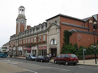
Spennymoor Town Hall is a municipal building in Spennymoor, County Durham, England. The town hall is the meeting place of Spennymoor Town Council.

<span class="mw-page-title-main">Anstruther Town Hall</span> Municipal building in Anstruther, Scotland

Anstruther Town Hall is a municipal building in School Green, Anstruther Easter, Fife, Scotland. The structure, which is used as a community events venue, is a Category B listed building.

<span class="mw-page-title-main">Lossiemouth Town Hall</span> Municipal building in Lossiemouth, Scotland

Lossiemouth Town Hall is a municipal building in the High Street in Lossiemouth, Moray, Scotland. The building is currently used as a community events venue.

<span class="mw-page-title-main">Ferryhill Town Hall</span> Municipal building in Ferryhill, County Durham, England

Ferryhill Town Hall is a municipal building in Chapel Terrace, Ferryhill, County Durham, England. The structure accommodates the offices and meeting place of Ferryhill Town Council.

<span class="mw-page-title-main">Upper Weardale Town Hall</span> Municipal building in St Johns Chapel, County Durham, England

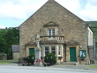
Upper Weardale Town Hall, also known as St John's Chapel Town Hall, is a municipal building on Hood Street, St John's Chapel, a village in County Durham, England. The building is currently in use as a community events venue.

References

  1. Crosby, June Hilda (1989). Weardale in Old Photographs. Gloucester: Alan Sutton Publishing. p. 26. ISBN   978-0862996949.
  2. House of Commons Parliamentary Papers Bills. Vol. 60. House of Commons. 1900. p. 27.
  3. "Stanhope". Kelly's Directory of Durham. 1890. Retrieved 27 January 2024.
  4. "Old Town Hall, Stanhope, Weardale, County Durham". J. B. Archive. 1910. Retrieved 27 January 2024.
  5. 1 2 "Stanhope Police Station". Prison History.org. Retrieved 27 January 2024.
  6. "County's oldest station closes after 135 years". The Northern Echo. 31 March 2008. Retrieved 27 January 2024.
  7. "Community association agrees police station deal". The Northern Echo. 28 September 2000. Retrieved 27 January 2024.
  8. "Stanhope Town Hall" (PDF). Addisons Estate Agents. Retrieved 26 January 2024.
  9. "Stanhope Town Hall". The Northern Echo. 25 January 2012. Retrieved 26 January 2024.
  10. Walton, Les (2021). Education: The Rock and Roll Years A Northern Perspective on a Lifetime of Learning, Teaching and Leading. Critical Publishing. p. 53. ISBN   978-1914171345.
  11. "Weardale". Chronicle Live. 15 November 2005. Retrieved 27 January 2024.
  12. "Stanhope Urban District Council Minutes 1914–1918" (PDF). Durham at War. p. 14. Retrieved 27 January 2024.
  13. "Home Front" (PDF). Durham County Council. Retrieved 27 January 2024.
  14. "Stanhope". North East War Memorials Project. Retrieved 27 January 2024.
  15. "Stanhope Roll of Honour". Imperial war Museum. Retrieved 27 January 2024.
  16. "Stanhope UD". Vision of Britain. Retrieved 27 January 2024.
  17. "Declare surplus, Stanhope Town Hall, Stanhope" (PDF). Durham County Council. Retrieved 27 January 2024.
  18. "Property For Sale – Stanhope Town Hall, Stanhope". Contract Finder Pro. Retrieved 26 January 2024.
  19. "Vehicle Ownership: Fatal Accidents and Rural Crime". 26 January 2022. Retrieved 27 January 2024.
  20. "Notes of the Weardale Area Action Partnership Board Meeting" (PDF). Durham County Council. 11 November 2021. Retrieved 26 January 2024.