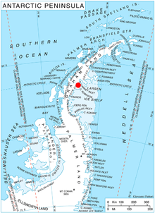
Palmer Land is the portion of the Antarctic Peninsula, Antarctica that lies south of a line joining Cape Jeremy and Cape Agassiz. This application of Palmer Land is consistent with the 1964 agreement between the Advisory Committee on Antarctic Names and the UK Antarctic Place-Names Committee, in which the name Antarctic Peninsula was approved for the major peninsula of Antarctica, and the names Graham Land and Palmer Land for the northern and southern portions, respectively. The line dividing them is roughly 69° S.
The Behrendt Mountains is a group of mountains, 20 nautical miles long, aligned in the form of a horseshoe with the opening to the southwest, standing 7 nautical miles southwest of the Merrick Mountains in Ellsworth Land, Antarctica.
The Hauberg Mountains are a group of mountains of about 35 nautical miles extent, located 12 nautical miles north of Cape Zumberge and 30 nautical miles south of the Sweeney Mountains in eastern Ellsworth Land, Antarctica.
The Scaife Mountains is a group of mountains rising west of Prehn Peninsula and between the Ketchum Glacier and Ueda Glacier, at the base of the Antarctic Peninsula.
Mikkelsen Bay is a bay, 15 nautical miles wide at its mouth and indenting 10 nautical miles, entered between Bertrand Ice Piedmont and Cape Berteaux along the west coast of Graham Land, Antarctica.
Northeast Glacier is a steep, heavily crevassed glacier, 13 nautical miles long and 5 nautical miles wide at its mouth, which flows from McLeod Hill westward and then south-westwards into Marguerite Bay between the Debenham Islands and Roman Four Promontory, on the west coast of Graham Land, Antarctica.

Joinville Island group is a group of antarctic islands, lying off the northeastern tip of the Antarctic Peninsula, from which Joinville Island group is separated by the Antarctic Sound.
Foundation Ice Stream is a major ice stream in the Pensacola Mountains of Antarctica. The ice stream drains northward for 150 nautical miles along the west side of the Patuxent Range and the Neptune Range to enter the Ronne Ice Shelf westward of Dufek Massif.
Gardner Inlet is a large, ice-filled inlet at the southwest side of Bowman Peninsula, on the east coast of Palmer Land, Antarctica.
The Hollick-Kenyon Peninsula(68°35′S63°50′W) is an ice-covered spur from the main mountain mass of the Antarctic Peninsula. It projects over 40 nautical miles in a northeasterly arc from its base between Mobiloil Inlet and Casey Inlet.
The Anderson Hills are an irregular group of hills, ridges and peaks between Mackin Table and the Thomas Hills in the Patuxent Range, Pensacola Mountains, Antarctica.
Bryan Coast is that portion of the coast of Antarctica along the south shore of the Bellingshausen Sea between Pfrogner Point and the northern tip of the Rydberg Peninsula. To the west is Eights Coast, and to the east is English Coast.
Carroll Inlet is an inlet, 40 nautical miles long and 6 nautical miles wide, trending southeast along the coast of Ellsworth Land, Antarctica, between the Rydberg Peninsula and Smyley Island. The head of the inlet is divided into two arms by the presence of Case Island and is bounded to the east by Stange Ice Shelf.
The Dana Mountains are a group of mountains just northwest of New Bedford Inlet, bounded by Mosby Glacier on the north and Haines Glacier and Meinardus Glacier on the south, in Palmer Land, Antarctica.
Mobiloil Inlet is an ice-filled inlet, nurtured by several northeast and east flowing glaciers, lying between the Rock Pile Peaks and Hollick-Kenyon Peninsula along the east coast of the Antarctic Peninsula.
The FitzGerald Bluffs are prominent north-facing bluffs, 9 nautical miles long, located 30 nautical miles south of the Snow Nunataks in Ellsworth Land, Antarctica.
Stefansson Strait is an ice-filled strait 35 nautical miles long and 3 to 10 nautical miles wide, between the east coast of Palmer Land and Hearst Island, Antarctica.

Stange Sound is a sound about 60 nautical miles long and 25 nautical miles wide along the coast of Ellsworth Land, Antarctica. An ice shelf occupies the sound, which is bounded on the west by Smyley Island and Case Island, on the south by the mainland, on the east by Spaatz Island and on the north by open water in the Ronne Entrance. Photographed from the air and roughly plotted by the Ronne Antarctic Research Expedition under Finn Ronne. Named for Henry Stange of New York, a contributor to RARE who gave much time to assisting in preparations for the expedition.

Sleipnir Glacier is a glacier 10 nautical miles (18 km) long, flowing into the west side of Cabinet Inlet between Balder and Spur Points, on the east coast of Graham Land, Antarctica. The Vologes Ridge is in the central portion of the glacier.
Rigsby Islands is a small group of ice-capped islands lying off the northeast coast of Adelaide Island, about 2 nautical miles (3.7 km) south of Sillard Islands. Mapped from air photos taken by Ronne Antarctic Research Expedition (RARE) (1947–48) and Falkland Islands and Dependencies Aerial Survey Expedition (FIDASE) (1956–57). Named by United Kingdom Antarctic Place-Names Committee (UK-APC) for George P. Rigsby, American geologist who has specialized in the investigation of ice crystal structure and the plasticity of ice.


