
A cable-stayed bridge has one or more towers, from which cables support the bridge deck. A distinctive feature are the cables or stays, which run directly from the tower to the deck, normally forming a fan-like pattern or a series of parallel lines. This is in contrast to the modern suspension bridge, where the cables supporting the deck are suspended vertically from the main cable, anchored at both ends of the bridge and running between the towers. The cable-stayed bridge is optimal for spans longer than cantilever bridges and shorter than suspension bridges. This is the range within which cantilever bridges would rapidly grow heavier, and suspension bridge cabling would be more costly.
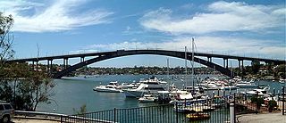
Gladesville Bridge is a heritage-listed concrete arch road bridge that carries Victoria Road over the Parramatta River, linking the Sydney suburbs of Huntleys Point and Drummoyne, in the local government areas of Canada Bay and Hunter's Hill, in New South Wales, Australia. Despite its name, the bridge is not located in Gladesville.

The Vashi Bridge, also known as Thane Creek Bridge or the Second Thane Creek Bridge, is a road bridge completed in the 1990s across Thane Creek, which connects the city of Mumbai to the Indian mainland at Navi Mumbai. The bridge links the suburb of Mankhurd in Mumbai with Vashi in Navi Mumbai, the satellite city of Mumbai. It is one of four entry points into Mumbai, and handles traffic directed towards the region to the south and east of Mumbai.

Mahatma Gandhi Setu is a bridge over the river Ganges in Bihar, India, connecting Patna in the south to Hajipur in the north. Its length is 5,750 metres (18,860 ft) and it is the third-longest river bridge in India. It was inaugurated in May 1982 in a ceremony in Hajipur by the then prime minister, Indira Gandhi. From 1982 to 2017, Mahatma Gandhi Setu remained as the longest bridge in India. Later, Gandhi Setu rehabilitation project was undertaken to install triangular steel trusses on Mahatma Gandhi Setu.
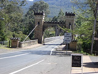
Hampden Bridge is a heritage-listed single-span suspension bridge that carries Moss Vale Road (B73) across the Kangaroo River, in Kangaroo Valley, in the City of Shoalhaven local government area of New South Wales, Australia. The bridge was designed by Ernest de Burgh and built by Loveridge and Hudson. The property is owned by Roads and Maritime Services, an agency of the Government of New South Wales. It was added to the New South Wales State Heritage Register on 2 August 2019.

Bowman Creek is a tributary of the Susquehanna River in Luzerne County and Wyoming County, in Pennsylvania, in the United States. It is approximately 26 miles (42 km) long and flows through Ross Township and Lake Township in Luzerne County and Noxen Township, Monroe Township, and Eaton Township in Wyoming County. The watershed of the creek has an area of 120 square miles (310 km2). The creek is not designated as an impaired waterbody and its pH is close to neutral, although it has experienced some problems with acid rain. It has low concentrations of dissolved solids like calcium. The creek is relatively small in its upper reaches, but by Noxen, its width is 40 to 60 feet. It is also relatively shallow in many reaches. Rock formations in the watershed include the Catskill Formation, the Huntley Mountain Formation, Burgoon Sandstone, the Mauch Chunk Formation, the Pottsville Group, and the Pocono Formation. Soil associations in the creek's watershed include the Wellsboro-Morris-Oquaga association, the Oquaga-Lackawanna-Arnot association, the Mardin-Bath-Volusia association, and the Wyoming-Pope association.

White Deer Creek is a tributary of the West Branch Susquehanna River in Centre County and Union County, in Pennsylvania, in the United States. It is approximately 28 miles (45 km) long and flows through Miles Township in Centre County and Hartley Township, Lewis Township, West Buffalo Township, and White Deer Township in Union County. The watershed of the creek has an area of 45.1 square miles (117 km2). Parts of the creek are designated as impaired. The creek's discharge near White Deer can be as low as 3 cubic feet per second (0.085 m3/s) or as high as 169 cubic feet per second (4.8 m3/s).
Harveys Creek is a tributary of the Susquehanna River in Luzerne County, Pennsylvania, in the United States. It is approximately 14.5 miles (23.3 km) long and flows through Harveys Lake, Lake Township, Lehman Township, Jackson Township, and Plymouth Township. The creek's watershed has an area of 46.3 square miles (120 km2). The creek has four named tributaries, which are known as Bear Hollow Creek, Paint Spring Run, Pikes Creek, and East Fork Harveys Creek. The watershed is designated as a High-Quality Coldwater Fishery and a Migratory Fishery above Pikes Creek and as a Coldwater Fishery and a Migratory Fishery below it. The creek's source is Harveys Lake, the largest natural lake in Pennsylvania.

The Hartland Covered Bridge in Hartland, New Brunswick, is the world's longest covered bridge, at 1,282 feet (391 m) long. It crosses the Saint John River from Hartland to Somerville, New Brunswick, Canada. The framework consists of seven small Howe Truss bridges joined together on six piers.

Maryland Route 194 (MD 194) is a state highway in the U.S. state of Maryland. The state highway runs 23.87 miles (38.42 km) from MD 26 in Ceresville north to the Pennsylvania state line near Taneytown, where the highway continues as Pennsylvania Route 194 (PA 194) toward Hanover. MD 194 is the main highway between Frederick and Hanover; the state highway connects the towns of Walkersville and Woodsboro in northeastern Frederick County with Keymar and Taneytown in northwestern Carroll County. MD 194 was blazed as a migration route in the 18th century and a pair of turnpikes in Frederick County in the 19th century, one of which was the last private toll road in Maryland. The state highway, which was originally designated MD 71, was built as a modern highway in Frederick County in the mid-1920s and constructed as Francis Scott Key Highway in Carroll County in the late 1920s and early 1930s. MD 194 received its modern route number in 1956 as part of a three-route number swap. The state highway's bypasses of Walkersville and Woodsboro opened in the early 1980s and mid-1990s, respectively.

The Lennox Bridge, Glenbrook is a heritage-listed road bridge that carries the Mitchell's Pass across Brookside Creek, located at Glenbrook, in the City of Blue Mountains local government area of New South Wales, Australia. The bridge was designed by David Lennox and built from 1832 to 1833 by James Randall and other convicts. It is also known as Lennox Bridge or The Horseshoe Bridge. The property is owned by Blue Mountains City Council. It was added to the New South Wales State Heritage Register on 2 April 1999. The stone arch bridge is a single arch of 6 metres (20 ft) span and is 9 metres (30 ft) above water level, with a road width of 9 metres (30 ft).

The Rock Creek Canyon Bridge is a large, multi-span, steel truss bridge on the Crowsnest Highway over Rock Creek Canyon in British Columbia. Originally built in 1951, the structure was widened and strengthened in 1992. Carrying two lanes of vehicular traffic, the bridge is 286 metres long and stands 91 metres above Rock Creek.

Dickabram Bridge is a heritage-listed road-and-rail bridge over the Mary River between Miva and Theebine, both in the Gympie Region, Queensland, Australia. It was the major bridge on the Kingaroy railway line. It was designed by Henry Charles Stanley and built from 1885 to 1886 by Owen McDermott & Co. It is also known as Mary River Bridge (Miva). The bridge was registered on the former Register of the National Estate in 1988. It was added to the Queensland Heritage Register on 21 October 1992.

The Taemas Bridge is a two-lane road bridge that carries the Wee Jasper Road across the Murrumbidgee River, at the settlement of Taemas, near Wee Jasper in the Yass Valley Council local government area of New South Wales, Australia. The bridge crosses on the river just before it enters Lake Burrinjuck, which has been created by the Burrinjuck Dam. The bridge is a key part of the road between Yass and Wee Jasper, and from there, to Tumut. The bridge is located approximately 26 kilometres (16 mi) from Yass and 22 kilometres (14 mi) from Wee Jasper. The property is owned by Roads and Maritime Services, an agency of the Government of New South Wales. Under the Heritage Act, 1977 (NSW) s 170, the bridge was added to the New South Wales State agency heritage register on 18 August 2005.

Clackline Bridge is a road bridge in Clackline, Western Australia, 77 kilometres (48 mi) east of Perth in the Shire of Northam, that carried the Great Eastern Highway until 2008. It is the only bridge in Western Australia to have spanned both a waterway and railway, the Clackline Brook and the former Eastern Railway alignment. The mainly timber bridge has a unique curved and sloped design, due to the difficult topography and the route of the former railway. The bridge was designed in 1934 to replace two dangerous rail crossings and a rudimentary water crossing. Construction began in January 1935, and was completed relatively quickly, with the opening ceremony held in August 1935. The bridge has undergone various improvement and maintenance works since then, including widening by three metres (10 ft) in 1959–60, but remained a safety hazard, with increasing severity and numbers of accidents through the 1970s and 1980s. Planning for a highway bypass of Clackline and the Clackline Bridge began in the 1990s, and it was constructed between January 2007 and February 2008. The local community had been concerned that the historic bridge would be lost, but it remains in use as part of the local road network, and has been listed on both the Northam Municipal Heritage Inventory and the Heritage Council of Western Australia's Register of Heritage Places.
Little Wapwallopen Creek is a tributary of the Susquehanna River in Luzerne County, Pennsylvania, in the United States. It is approximately 17 miles (27 km) long and flows through Rice Township, Dorrance Township, Conyngham Township, and Hollenback Township. The watershed of the creek has an area of 39.5 square miles (102 km2). The creek is designated as a Coldwater Fishery and a Migratory Fishery and is not considered to be impaired. It has two named tributaries: Pond Creek and Nuangola Outlet. Wild trout naturally reproduce in the creek.
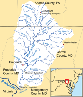
Alloway Creek is a 13.5-mile-long (21.7 km) tributary of the Monocacy River in Pennsylvania and Maryland in the United States. Via the Monocacy River, it is part of the Potomac River watershed.

Aquetong Creek is a tributary of the Delaware River in Solebury Township and New Hope, Bucks County, Pennsylvania. Rising from the Aquetong Spring, now known as Ingham Spring, just south of the intersection of U.S. Route 202, Lower Mountain Road, and Ingham Road, it runs about 10.75 miles (17.30 km) to its confluence with the Delaware.

The Tooleybuc Bridge is a dual heritage-listed road bridge that carries Tooleybuc Road across the Murray River, located in Tooleybuc in the Murray River Council local government area of New South Wales, Australia. It was built in 1925. The bridge is owned by the Murray River Council, and is also called the Tooleybuc Bridge over Murray River. The bridge was added to the New South Wales State Heritage Register on 20 June 2000 and the Victorian Heritage Register on 10 July 2008.
The Beckers Bridge over Webbers Creek is a heritage-listed timber truss road bridge that carries Main Road across Webbers Creek, located in Glendon Brook, Singleton Council, New South Wales, Australia. It was designed by Ernest de Burgh. The property is owned by Roads and Maritime Services, an agency of the Government of New South Wales. It was added to the New South Wales State Heritage Register on 20 June 2000.
