Related Research Articles

Big Bear City is an unincorporated community in San Bernardino County, California, United States along the east shore of Big Bear Lake and surrounded by the San Bernardino National Forest. It is 27 miles (43 km) northeast of the city of San Bernardino, and immediately east of the incorporated city of Big Bear Lake. For statistical purposes, the United States Census Bureau has defined Big Bear City as a census-designated place (CDP). Its population was 12,304 at the 2010 census, up from 5,779 at the 2000 census. Big Bear City is mostly residential, with smaller houses and cabins laid out in typical square block fashion. Big Bear is on the Pacific Crest Trail.

Big Bear Lake is a city in San Bernardino County, California, located in the San Bernardino Mountains along the south shore of Big Bear Lake, and surrounded by the San Bernardino National Forest. The city is about 25 miles (40 km) northeast of the city of San Bernardino, and immediately west of the unincorporated town of Big Bear City. The population was approximately 5,019 at the 2010 census, down from 5,438 at the 2000 census. However, as a popular year-round resort destination, the actual number of people staying in or visiting the greater Big Bear Valley area regularly surges to over 100,000 during many weekends of the year.

Running Springs is a census-designated place (CDP) in San Bernardino County, California, United States. The population was 5,268 at the 2020 census, up from 4,862 at the 2010 census. Running Springs is situated 17 miles west of the city of Big Bear Lake.

The California grizzly bear, also known as the California golden bear, is an extinct population of the brown bear, generally known as the grizzly bear. "Grizzly" could have meant "grizzled" – that is, with golden and grey tips of the hair – or "fear-inspiring". Nonetheless, after careful study, naturalist George Ord formally classified it in 1815 – not for its hair, but for its character – as Ursus horribilis. Genetically, North American brown bears are closely related; in size and coloring, the California grizzly bear was much like the Kodiak bear of the southern coast of Alaska. The grizzly became a symbol of the Bear Flag Republic, a moniker that was attached to the short-lived attempt by a group of U.S. settlers to break away from Mexico in 1846. Later, this rebel flag became the basis for the state flag of California, and then California was known as the "Bear State".

Big Bear Lake is a reservoir in the western United States, located in the San Bernardino Mountains in San Bernardino County, California. It is a snow and rain-fed lake, having no other means of tributaries or mechanical replenishment.

Nahanni National Park Reserve in the Dehcho Region of the Northwest Territories, Canada, approximately 500 km (311 mi) west of Yellowknife, protects a portion of the Mackenzie Mountains Natural Region. The centrepiece of the park is the South Nahanni River. Four noteworthy canyons reaching 1,000 m (3,300 ft) in depth, called First, Second, Third and Fourth Canyon, line its whitewater river. The name Nahanni comes from the indigenous Dene language name for the area; Nahʔa Dehé, which means "river of the land of the Nahʔa people". The park was among the world's first four natural heritage locations to be inscribed as World Heritage Sites by UNESCO in 1978 because of its picturesque wild rivers, canyons, and waterfalls.

The San Bernardino Mountains are a high and rugged mountain range in Southern California in the United States. Situated north and northeast of San Bernardino and spanning two California counties, the range tops out at 11,503 feet (3,506 m) at San Gorgonio Mountain – the tallest peak in Southern California. The San Bernardinos form a significant region of wilderness and are popular for hiking and skiing.

Angelus Oaks is an unincorporated community in San Bernardino County, California, United States, and has a population of 535 as of the 2010 U.S. Census, up from an estimated population of 312 in 2000. It is surrounded by the San Bernardino National Forest and located east of San Bernardino on California State Route 38.

Located in Los Angeles County, California's San Gabriel Valley, the Boy Scouts of America's San Gabriel Valley Council (#40) was one of five councils serving Los Angeles County. It was headquartered in Pasadena.
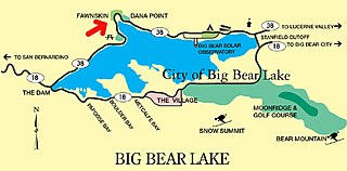
Fawnskin is an unincorporated community in San Bernardino County, California, United States. It is located on the northwest side of Big Bear Valley, in the heart of the San Bernardino Mountains, at an altitude of 6,827 feet (2,081 m). The tiny community has a "permanent" population of 380, and many vacation homes that range from multi-million dollar mansions to decaying log cabins. Fawnskin has its own US Post Office, established on May 18, 1918, but to this day, mail must be picked up because there is no delivery service.

Baldwin Lake is a natural, intermittent, alkali lake in the Big Bear Valley of the San Bernardino Mountains, in San Bernardino County, California. It is located east of Big Bear Lake reservoir and Big Bear City.

Holcomb Valley, located in the San Bernardino Mountains about five miles north of Big Bear Lake, was the site of the most gold mines in Southern California. It was named after William F. Holcomb, who found gold there in 1860. That year started the largest gold rush in the Southern California region. The boomtown of Belleville grew up near there and flourished for about ten years before being abandoned. The site is now registered as California Historical Landmark #619.
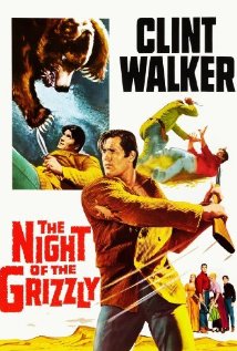
The Night of the Grizzly is a 1966 Western film starring Clint Walker, Martha Hyer, Keenan Wynn, Jack Elam and Nancy Kulp. Directed by Joseph Pevney and written by Warren Douglas, the film was released by Paramount Pictures on April 20, 1966. It was Pevney's final feature film.
William Francis "Grizzly Bill" Holcomb, was an American prospector and the first to discover gold in the region which became known as Holcomb Valley, near present-day Big Bear Lake, California. Holcomb Valley had the most gold of any Southern California field. The boomtown of Belleville grew up there and for a time was the third or fourth largest in Southern California. Holcomb was the first justice of the peace in Belleville and later was elected to county offices.
Belleville, California was a gold mining boomtown in the San Bernardino Mountains of San Bernardino County, California. The settlement grew up rapidly following the discovery of gold by William F. Holcomb in Holcomb Valley early 1860. Which helped the town challenge the seat of San Bernardino County. Belleville was named after Belle, the first child born in the new town. It was a busy mining town for ten years, it was virtually abandoned before the end of the 19th century. It is now a ghost town.
Gold Mountain Manor is a rustic hotel, bed & breakfast, and wedding venue on the north shore of Big Bear City, California. Built in 1928 by Los Angeles movie investor Alexander Buchanan Barret and his wife, Bessie, Gold Mountain Manor is currently owned and managed by Darrin and Amy Odell.
Whispering Forest is a residential community on the hills of the North Shore of Big Bear City, CA, just north of the Big Bear City Airport. The neighborhood is located less than a mile north-east of Baker Pond and just 500 feet north of the airport. It borders National Forest to the north, Division Drive to the west, and the West North Shore Drive to the south. It is situated at the base of National Forest and backs to woodlands and densely forested areas to the north. Areas such as Holcomb Valley, the Pacific Crest Trail and Caribou Creek are all accessible to the north through Van Dusen Canyon Road in the east. It is an established neighborhood developed by the Whispering Forest Development Company. It is situated at a 6,750 feet elevation and is frequently suffering wildfires during the hotter summer months. The neighborhood is also frequently visited by wildlife such as black bears and mountain lions.
The Holcomb Fire was a wildfire that burned due north of Big Bear Lake near Highway 18 in the San Bernardino National Forest in San Bernardino County, California. Within several days, the fire would consume some 1,500 plus acres as it threatened the areas of Baldwin Lake and Highway 18. However, while the fire rapidly grew in size, the head of the fire was seen to be moving away from structures, thus leaving evacuated areas under voluntary evacuation.
Seven Oaks is an unincorporated mountain community in the San Bernardino Mountains. It sits by the Santa Ana River, 7 miles northeast of Angelus Oaks. Seven Oaks Road leads to the neighboring community of Pinezanita, 3.5 miles west of Seven Oaks. It is located 4 miles off Highway 38. It is a resort community which was founded in 1845.

The Santa Fe And Salt Lake Trail Monument was designated a California Historic Landmark (No.576) on May 17, 1957. Santa Fe And Salt Lake Trail Monument marks the place two Historic trail merged in Cajon Pass in San Bernardino County, California. The Old Spanish Trail and the Mohave Trail-Mojave Road merged in Cajon Pass. The large white marker is just off the Interstate 15 in Cajon Pass, was U.S. Route 66 in the past. It was built by the Pioneer Society of San Bernardino to remember and honor the pioneers that came west. The marker is 12 feet tall and 7 feet square at the base. Cajon Pass was home to the Serrano Indian, Native Californians that lived in the nearby Atongaibit village, in what is now Hesperia.