State Road 105 (Serbia)

Last updated

R105-SRB.svg

State Road 105
  • Државни пут IIА реда 105
  • Državni put IIA reda 105
Regional Road 105 map.png
Route information
Maintained by JP "Putevi Srbije"
Length100.506 km (62.452 mi)
Major junctions
From HungarySerbia border at Bajmok, Road 5312
ToSerbia – Romania border at Vrbica, Road DJ682B
Location
Districts North Bačka, North Banat
Highway system
IIA-Class Highways in Serbia
R104-SRB.svg IIA-104 IIA-106 R106-SRB.svg

State Road 105, is an IIA-class road in northern Serbia, connecting Hungary at Bajmok with Romania at Vrbica. It is located in Vojvodina. [1]

Contents

Before the new road categorization regulation given in 2013, the route wore the following names: P 108, M 22.1, P 119, M 24, and P 112 (before 2012) / 103, 102, 120, 101, 11 and 100 (after 2012). [2] [3]

The existing route is a regional road with two traffic lanes. By the valid Space Plan of Republic of Serbia the road is not planned for upgrading to main road, and is expected to be conditioned in its current state. [4]

Sections

Section numberLength (km)Distance (km)Section name
105018.535 km (5.303 mi)8.535 km (5.303 mi) HungarySerbia border (Bajmok) – Bajmok
1050218.606 km (11.561 mi)27.141 km (16.865 mi)Bajmok – Bački Sokolac
105038.274 km (5.141 mi)35.415 km (22.006 mi)Bački Sokolac – Bačka Topola (Kula)
105040.389 km (0.242 mi)35.804 km (22.248 mi)Bačka Topola (Kula) – Bačka Topola (Bački Sokolac)
100080.752 km (0.467 mi)36.556 km (22.715 mi)Bačka Topola (Bački Sokolac) – Bačka Topola (Tornjoš) (overlap with R100-SRB.svg )
105051.146 km (0.712 mi)37.702 km (23.427 mi)Bačka Topola (Tornjoš) – Bačka Topola (Bečej)
105064.343 km (2.699 mi)42.045 km (26.126 mi)Bačka Topola (Bečej) – Bačka Topola interchange
1050713.042 km (8.104 mi)55.087 km (34.229 mi)Bačka Topola interchange – Tornjoš
1050815.852 km (9.850 mi)70.939 km (44.079 mi)Tornjoš – Gornji Breg (Novo Orahovo)
102043.635 km (2.259 mi)74.574 km (46.338 mi)Gornji Breg (Novo Orahovo) – Senta (Subotica road) (overlap with R102-SRB.svg )
105096.557 km (4.074 mi)81.131 km (50.412 mi)Senta (Subotica road) – Čoka (Senta)
013060.377 km (0.234 mi)81.508 km (50.647 mi)Čoka (Senta) – Čoka (Crna Bara) (overlap with M13-SRB.svg )
1051012.329 km (7.661 mi)93.837 km (58.308 mi)Čoka (Crna Bara) – Crna Bara
104032.216 km (1.377 mi)96.053 km (59.685 mi)Crna Bara – Crna Bara (Mokrin) (overlap with R104-SRB.svg )
105114.453 km (2.767 mi)100.506 km (62.452 mi)Crna Bara (Mokrin) – Serbia-Romania border (Vrbica)

See also

Related Research Articles

State Road 12 (Serbia) road in Serbia

State Road 12, is an IB-class road in northern Serbia, connecting Subotica with Romania. It is located in Vojvodina.

State Road 13 (Serbia) road in Serbia

State Road 13, is an IB-class road, located in northern Serbia, connecting Horgoš with Belgrade. It is located in Vojvodina and City of Belgrade.

State Road 15 (Serbia) road in Serbia

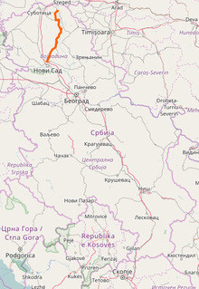
State Road 15, is an IB-class road in northern Serbia, connecting Hungary at Bački Breg with Romania at Nakovo. It is located in Vojvodina.

State Road 18 (Serbia) road in Serbia

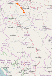
State Road 18, is an IB-class road in northern Serbia, connecting Zrenjanin with Romania at Kaluđerovo. It is located in Vojvodina.

State Road 28 (Serbia) road in Serbia

State Road 28 is an IB-class road in western Serbia, connecting Mali Zvornik with Bosnia and Herzegovina at Kotroman. It is located in Šumadija and Western Serbia.

State Road 29 (Serbia) road in Serbia

State Road 29 is an IB-class road in western Serbia, connecting Montenegro at Jabuka with Novi Pazar. It is located in Šumadija and Western Serbia.

State Road 33 (Serbia) road in Serbia

State Road 33 is an IB-class road in eastern Serbia, connecting Ralja with Bulgaria at Mokranje. It is located in Southern and Eastern Serbia.

State Road 100 (Serbia) IIA-class road in northern Serbia

State Road 100, is an IIA-class road in northern Serbia, connecting Horgoš with Batajnica. It is located in Vojvodina and City of Belgrade.

State Road 102 (Serbia) IIA-class road in northern Serbia

State Road 102, is an IIA-class road in northern Serbia, connecting Kanjiža with Novi Sad. It is located in Vojvodina.

State Road 104 (Serbia) IIA-class road in northern Serbia

State Road 104, is an IIA-class road in northern Serbia, connecting Novi Kneževac with Romania at Međa. It is located in Vojvodina.

State Road 107 (Serbia) IIA-class road in northern Serbia

State Road 107, is an IIA-class road in northern Serbia, connecting Sombor with Bogojevo. It is located in Vojvodina.

State Road 108 (Serbia) IIA-class road in northern Serbia

State Road 108, is an IIA-class road in northern Serbia, connecting Bačka Topola with Croatia at Bačka Palanka. It is located in Vojvodina.

State Road 110 (Serbia) IIA-class road in northern Serbia

State Road 110, is an IIA-class road in northern Serbia, connecting Kula with Odžaci. It is located in Vojvodina.

State Road 111 (Serbia) IIA-class road in northern Serbia

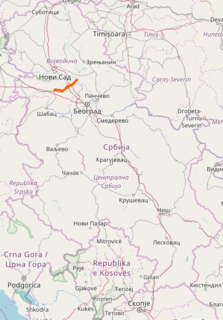
State Road 111, is an IIA-class road in northern Serbia, connecting Odžaci with Novi Sad. It is located in Vojvodina.

State Road 112 (Serbia) IIA-class road in northern Serbia

State Road 112, is an IIA-class road in northern Serbia, connecting Bačko Novo Selo with Žabalj. It is located in Vojvodina.

State Road 125 (Serbia) road in Serbia

State Road 125, is an IIA-class road in northern Serbia, connecting Maradik interchange with the village itself. It is located in Vojvodina.

State Road 126 (Serbia) road in Serbia

State Road 126, is an IIA-class road in northern Serbia, connecting Ruma with Stari Slankamen. It is located in Vojvodina.

State Road 129 (Serbia) road in Serbia

State Road 129, is an IIA-class road in northern Serbia, connecting Kać with Romania at Jaša Tomić. It is located in Vojvodina.

State Road 130 (Serbia) road in Serbia

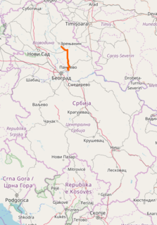
State Road 130, is an IIA-class road in northern Serbia, connecting Ečka with Pančevo. It is located in Vojvodina.

State Road 131 (Serbia) road in Serbia

State Road 131, is an IIA-class road in northern Serbia, connecting Čenta with Jabučki Rit. It is located in Vojvodina.

References

  1. "Republic of Serbia – national road network" (PDF). Putevi Srbije (in Serbian).
  2. "National road categorization regulation – Official Gazette of Republic of Serbia no. 105/2013 and 119/2013" (PDF). Serbian Spatial Planners Association (in Serbian).
  3. "Link between actual and previous section and road markings" (PDF). Putevi Srbije (in Serbian).
  4. Space plan of Republic of Serbia from 2010 to 2021