State Road 28 (Serbia)

Last updated • 1 min readFrom Wikipedia, The Free Encyclopedia
M28-SRB.svg
State Road 28
Serbian: Državni put IB reda 28
Serbian Cyrillic: Државни пут IБ реда 28
State Road 28 map.png
Route information
Part of E761-SRB.svgE763-SRB.svg E761  / E763 Užice-Sušica
E761-SRB.svg E761 Sušica-Kotroman
Maintained by JP "Putevi Srbije"
Length172.486 km (107.178 mi)
Major junctions
From Mali Zvornik M26-SRB.svg 26
To Serbia-Bosnia and Herzegovina border at Kotroman M5-BIH.svg M-5
Location
Country Serbia
Districts Mačva, Zlatibor
Highway system
M27-SRB.svg 27 M29-SRB.svg 29

State Road 28 is an IB-class road in western Serbia, connecting Mali Zvornik with Bosnia and Herzegovina at Kotroman. It is located in Šumadija and Western Serbia. [1]

Contents

Before the new road categorization regulation given in 2013, the route wore the following names: M 19.1, P 111, M 5, M 21 and P 112 (before 2012) / 144, 143, 145 and A4 (after 2012). [2] [3]

The existing route is a main road with two traffic lanes. By the valid Space Plan of Republic of Serbia the road is not planned for upgrading to motorway, and is expected to be conditioned in its current state. [4]

Section from Užice to Serbia-Bosnia and Herzegovina border is a part of E761, while Užice-Sušica part also bears the route E763.

Sections

Section numberLengthDistanceSection name
0280137.730 km (23.444 mi)37.730 km (23.444 mi) Mali Zvornik - Gračanica
028027.064 km (4.389 mi)44.794 km (27.834 mi)Gračanica - Ljubovija
0280335.703 km (22.185 mi)80.497 km (50.019 mi)Ljubovija - Rogačica (Debelo Brdo)
028040.102 km (0.063 mi)80.599 km (50.082 mi)Rogačica (Debelo Brdo) - Rogačica (Bajina Bašta)
028057.089 km (4.405 mi)87.688 km (54.487 mi)Rogačica (Bajina Bašta) - Kostojevići
028067.026 km (4.366 mi)94.714 km (58.853 mi)Kostojevići - Dub
0280717.105 km (10.629 mi)111.819 km (69.481 mi)Dub - Dubci
028088.396 km (5.217 mi)120.215 km (74.698 mi)Dubci - Užice (Gostinica)
028090.675 km (0.419 mi)120.890 km (75.118 mi)Užice (Gostinica) - Užice (Karan)
028100.038 km (0.024 mi)120.928 km (75.141 mi)Užice (Karan) - Užice
028118.180 km (5.083 mi)129.108 km (80.224 mi)Užice - Bela Zemlja (overlap with M23-SRB.svg )
023217.013 km (4.358 mi)136.121 km (84.582 mi)Bela Zemlja - Sušica (overlap with M23-SRB.svg )
0232216.270 km (10.110 mi)152.391 km (94.691 mi)Sušica - Kremna
028121.879 km (1.168 mi)154.270 km (95.859 mi)Kremna - Kremna (Tara)
0281318.216 km (11.319 mi)172.486 km (107.178 mi)Kremna (Tara) - Serbia-Bosnia and Herzegovina border at Kotroman

See also

Related Research Articles

<span class="mw-page-title-main">State Road 12 (Serbia)</span> Road in Serbia

State Road 12, is an IB-class road in northern Serbia, connecting Subotica with Romania. It is located in Vojvodina.

<span class="mw-page-title-main">State Road 15 (Serbia)</span> Road in Serbia

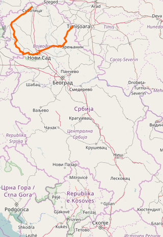
State Road 15, is an IB-class road in northern Serbia, connecting Hungary at Bački Breg with Romania at Nakovo. It is located in Vojvodina.

<span class="mw-page-title-main">State Road 16 (Serbia)</span> Road in Serbia

State Road 16, is an IB-class road in northern Serbia, connecting Croatia at Bezdan with State Road 15. It is located in Vojvodina.

<span class="mw-page-title-main">State Road 18 (Serbia)</span> Road in Serbia

State Road 18, is an IB-class road in northern Serbia, connecting Zrenjanin with Romania at Kaluđerovo. It is located in Vojvodina.

<span class="mw-page-title-main">State Road 19 (Serbia)</span> Road in Serbia

State Road 19, is an IB-class road in northern Serbia, connecting Bačka Palanka with Bosnia and Herzegovina at Sremska Rača. It is located in Vojvodina.

<span class="mw-page-title-main">State Road 20 (Serbia)</span> Road in Serbia

State Road 20 is an IB-class road in northern and western Serbia, connecting Sremska Mitrovica with Bosnia and Herzegovina at Badovinci. It is located in Vojvodina and Šumadija and Western Serbia regions.

<span class="mw-page-title-main">State Road 21 (Serbia)</span> Road in Serbia

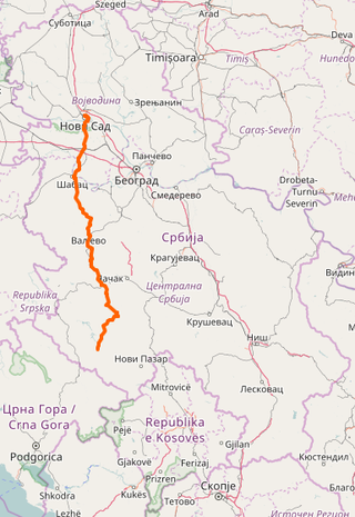
State Road 21 is an IB-class road in northern and western Serbia, connecting Novi Sad with Sjenica. It is in Vojvodina and Šumadija and Western Serbia regions.

<span class="mw-page-title-main">State Road 22 (Serbia)</span> Road in Serbia

State Road 22, commonly known as Ibar Highway, is an IB-class road, connecting Belgrade with Šumadija and Western Serbia and finally with Montenegro at Špiljani border crossing.

<span class="mw-page-title-main">State Road 23 (Serbia)</span> Road in Serbia

State Road 23, from Čačak via Zlatibor commonly known as Zlatibor Highway, is an IB-class road in central and western Serbia, connecting Pojate with Montenegro at Gostun. It is located in Šumadija and Western Serbia.

<span class="mw-page-title-main">State Road 24 (Serbia)</span> Road in Serbia

State Road 24 is an IB-class/expressway road in central Serbia, connecting Batočina with Kraljevo. It is located in Šumadija and Western Serbia.

<span class="mw-page-title-main">State Road 25 (Serbia)</span> Road in Serbia

State Road 25 is an IB-class road in northern and central Serbia, connecting Mali Požarevac with Kragujevac. It is located in Belgrade and Šumadija and Western Serbia regions.

<span class="mw-page-title-main">State Road 26 (Serbia)</span> Road in Serbia

State Road 26 is an IB-class road in northern and central Serbia, connecting Belgrade with Bosnia and Herzegovina at Mali Zvornik. It is located in Belgrade and Šumadija and Western Serbia regions.

<span class="mw-page-title-main">State Road 27 (Serbia)</span> Road in Serbia

State Road 27 is an IB-class road in western, northern, central and eastern Serbia, connecting Bosnia and Herzegovina at Trbušnica with Svilajnac. It is located in Šumadija and Western Serbia, Belgrade and Southern and Eastern Serbia regions.

<span class="mw-page-title-main">State Road 29 (Serbia)</span> Road in Serbia

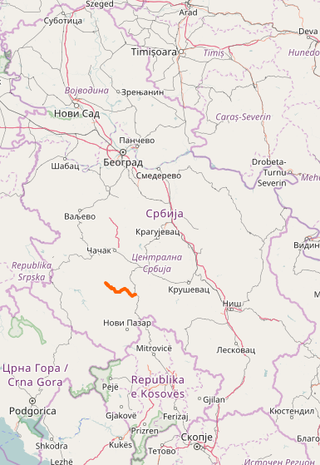
State Road 29 is an IB-class road in western Serbia, connecting Montenegro at Jabuka with Novi Pazar. It is located in Šumadija and Western Serbia.

<span class="mw-page-title-main">State Road 30 (Serbia)</span> Road in Serbia

State Road 30 is an IB-class road in western Serbia, connecting Ivanjica with Ušće. It is located in Šumadija and Western Serbia.

<span class="mw-page-title-main">State Road 32 (Serbia)</span> Road in Serbia

State Road 32 is an IB-class road in southwestern Serbia and Kosovo, connecting Ribariće with Mitrovica.

<span class="mw-page-title-main">State Road 35 (Serbia)</span> Road in Serbia

State Road 35 is an IB-class road in southeastern Serbia and Kosovo, connecting Romania at HE Đerdap I with Albania at Vërmica.

<span class="mw-page-title-main">State Road 36 (Serbia)</span> Road in Serbia

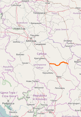
State Road 36 is an IB-class road in western and eastern Serbia, connecting Paraćin with Bulgaria at Vrška Čuka. It is located in Šumadija and Western Serbia and Southern and Eastern Serbia regions.

<span class="mw-page-title-main">State Road 46 (Serbia)</span> Road in central and western Serbia

State Road 46 is an IB-class road in central and western Serbia, connecting Ravni Gaj with Mrčajevci. It is located in Šumadija and Western Serbia.

<span class="mw-page-title-main">State Road 121 (Serbia)</span> Road in Serbia

State Road 121, is an IIA-class road in northern Serbia, connecting Croatia at Sot with Bosnia and Herzegovina at Jamena. It is located in Vojvodina.

References

  1. "Republic of Serbia - national road network" (PDF). Putevi Srbije (in Serbian).
  2. "National road categorization regulation - Official Gazette of Republic of Serbia no. 105/2013 and 119/2013" (PDF). Serbian Spatial Planners Association (in Serbian).
  3. "Link between actual and previous section and road markings" (PDF). Putevi Srbije (in Serbian).
  4. Space plan of Republic of Serbia from 2010 to 2021