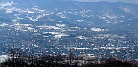
The population of the town, according to 2022 census, is 8,971 inhabitants, while the municipality has 25,724 inhabitants.
History
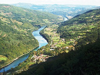
The Drina valley looking towards Bajina Bašta.
In 1834 Bajina Bašta was established on the remains of the old Turkish community of Pljeskovo which was situated on the right bank of the Drina River between the Rača and Pilica Rivers, under the east foothills of Tara Mountain. By the end of the 19th century, in accordance with the Serbian-Turkish agreement, the local Muslims had to move from this region directly across the Drina River into Bosnia, where they built settlements in the villages of Skelani and Dobrak.
The name Bajina Bašta comes from the vast orchards and vegetable gardens, that used to be located on the left bank of the Pilica River, which belonged to Turkish feudal owner, Baja Osman, who established the town's modern image in the mid-19th century. In English, the name Bajina Bašta literally means "Baja’s Garden". In 1858 the town became the administrative center of the Rača District. On September 15, 1872, Prince Milan Obrenović IV issued a decree that officially gave Bajina Bašta its status as an officially recognized town. A decade later, Bajina Bašta received its urban plan, long before many places in Serbia.
Under the Ottoman Empire, the Rača's region became a part of Sokolska nahija or Zvornik Sandžak, and later on a part of Užice nahija where it remained until its liberation from the Turks in 1834. In the following tumultuous decades, Bajina Bašta belonged to the Užice District, Užice canton, and region. Today, the town lies in the Zlatibor District. In 1875 a mixed craftsmen guild was founded with 88 different occupations, based on forestry and stock farming. In attempts to improve trade links between Serbia and Bosnia, the first customs station was opened in Skelani in 1880. The following year, the first post office with a telegraph was opened. The number of inhabitants increased from 374 in 1864 to 1,306 by 1910. Residents in the nearby village of Rača made a major contribution in liberation efforts between 1876–1878 when Serbia became an independent principality, declared by the Congress of Berlin. In the following Balkan Wars and World War I (1912–1918) over 300 people from this small village died.
Roman ruins in downtown Bajina Bašta.
The areas around Bajina Bašta have significant historical heritage. In the village of Pilica, there are archeological remains of Roman architecture dating from the 2nd and 3rd century and ornamented tombstones. Other archeological sites lie in the Kremna valley (43 tombstones), Mokra Gora (38), Perućac, Rastište and Dub. The oldest historical findings in this area date from the Neolithic period (5,000 year B.C.) – remains of these communities, Kremenilo and Jokin Breg, are found near Višesava. The remnants of these settlements show that people lived in about 2.5 m deep dugouts, on three underground levels. Judging by their characteristics, these remains are considered to have belonged to the Starčevo culture. Additionally, there is much evidence of the Iron Age material culture of the Illyrian tribe of Autariat (after which Tara Mountain most likely obtained its name). During Roman, Byzantine and Medieval period, Bajina Bašta was an important trade center and the cross-border with Bosnia.
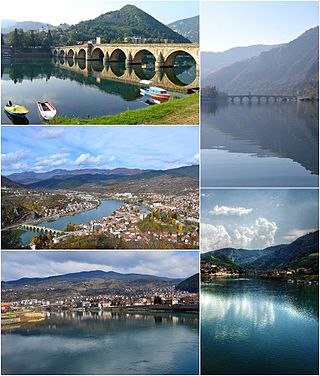
Rača monastery (7km southwest of town) is considered the most significant historical treasure of the area. Built by King Stefan Dragutin (1276–1282), the monastery was the center of transcription and illumination of medieval religious manuscripts of Serbia. These monks became known as the Račani. Abundant wall paintings and iconostasis cover the walls, dating after the church's reconstruction in 1835. The monastery houses a treasury and a library containing over 1,200 books and manuscripts. In the village of Dub (10km from Bajina Bašta) there is a wooden church from 1792, of a specific architecture, covered with shingle roof. A variety of ornaments and icons, a gate from the 17th century, make this church one of the more memorable churches in Serbia.
1918–1945
The Monument to the Unknown Soldier from World War II.
During the unification of the Southern Slavs of Europe and creation of the Kingdom of Serbs, Croats and Slovenes, Bajina Bašta continued its urban expansion. In 1926, a metal bridge that linked to Skelani was built, replacing the ferry that crossed the Drina River. The electrification of the town started in 1928 and two years later the first town's hospital was built. The utilization of forests, the famed bajinactobacco and the construction of elementary schools in the region greatly helped improve the standard of living and educational level of the inhabitants. In 1940, the downtown area built its first water piping and sewage system and cobblestone streets.
During World War II, Bajina Bašta was severely damaged. Events that marked human history in the period between 1939–1945, were reflected in this region as well in a form of civil war and liberation fights against the occupying Axis army. A Račan militia was formed in the first stages of the armed resistance against the occupants. From August 3–23, 1941, the militia solidified into a military formation consisting of 62 soldiers. The first free territory in the occupied Europe – "Republic of Užice", brought only temporary liberation to Bajina Bašta. In this region, the first People's Liberation Committee NOO was formed. During the war, especially in 1943, Bulgarian forces caused many civilian casualties. Bajina Bašta was liberated from Nazi forces on September 12, 1944.
1945–1999
After the World War II ended, Bajina Bašta continued to develop into an economical, cultural and administrative center of the municipality which extended 672km2 (418 miles²) around the town. The second half of the 20th century is marked by the expansion of trade, banking, agricultural cooperatives, sawmills and craftsmen guilds. Intensive economic growth began in 1966 when the Bajina Bašta Hydroelectric Power Plant in Perućac was put in operation. This is the second largest hydroelectric power plant in Serbia today, after Đerdap on the Danube River.
During the turmoil in Bosnia-Hercegovina 1992–1995 (Bosnian War) Bajina Bašta came under occasionally shelling from Bosnian Muslims (Bosniaks) offensive operations in early 1993. Several villages north of Bajina Bašta along the Drina river on the Serbian side came under fire in this period. First when the VRS (Bosnian Serb army)[clarification needed] later during 1993 launched counter offensive operations the sporadic attacks stopped.
1999–present
Bajina Bašta's main street.
The town has preserved architecture from the end of the 19th and the first half of the 20th century, which goes along well with the more recent urban structures. Rural settlements are more archaic in layout and building structure, the most attractive and significant ones are Rogačica, the former center of the Rača district, as well as Kostojevići, Pilica, and other localities.
The expansion and development of Bajina Bašta by the modern urbanization plan was directed along the main streets which are part of the main routes from Užice to Perućac (Kneza Milana Obrenovića Street) and Rogačica to Tara (Svetosavska Street). These routes intersect in the town's center. Bajina Bašta is considered a modern urban settlement with potential for horizontal expansion. Downtown Bajina Bašta is a mixture of commercial, residential, and administrative buildings of different facades and height. The heart of the town is Dušana Jerkovića Square, which is surrounded by the old-style architecture found in Serbia during the mid to late 19th century.
Climate
Bajina Bašta's climate is moderate continental with four distinct seasons. Summers are warm and pleasant with cool nights, and winters are sunny, with snow levels high enough for widespread winter sports. However, the humidity of the air increased greatly after the construction of the power plant in Perućac and the formation of the artificial Perućac Lake and Zaovine Lake, in the mountains. The average annual rainfall is 700–800mm locally, contributing to a marked agricultural environment.
According to the 2011 census results,[5] the municipality of Bajina Bašta has 26,022 people. The town itself hosts 9,148 people while the other 16,874 live in thirty-five outlying villages and non-urban areas surrounding the town.
Most of the residing population are immigrants, who after the liberation of the area from the Turks in the 19th century, settled these areas, originally coming from Herzegovina, the northwestern parts of Montenegro, Sandžak, Osat (Bosnia), Dalmatia (Pepelj) and Kremna. At present, a considerable decrease in population is recorded due to economic migrations towards the regional centers of Serbia, such as Užice, Valjevo, Čačak, and Belgrade.
Bajina Bašta Hydroelectric Power Plant in Perućac.
The greatest natural resources of the municipality are the Drina River and Tara Mountain. The Drina is especially significant for its water power potentials. Specialists have estimated that it is possible to erect several hydroelectric power plants on this river. The annual flow of the Drina River is about 12.5 cubic kilometers of water. The Bajina Bašta Hydroelectric power plant was built on the Drina to harness that energy. The dam is located 12km west of Bajina Bašta, near Perućac. Its average annual production amounts to 1,625 GWh of electric power. For the sake of better utilization of water power potential, the first reversible hydro-electric power plant in Europe was built in Zaovine, near the top of Tara Mountain.
Tara Mountain has long been a well-known tourist resort owing to its pleasant moderately continental and sub-continental climate. In 1981, Tara became a national park. It covers an area of 300 square kilometers and is the largest natural park in Serbia. The mountain has an abundance of flora and fauna. Apart from white pine tree, maple-trees and famous Serbian Spruce (Picea omorika), here you can find rare game including bear, roe deer, and chamois. The Drina River is a part of the local cultural identity and has great potential in rafting sports and fishing.
Moderate continental and mountainous climatic conditions are especially suitable for recovery and medical treatment of patients with bronchial asthma, chronic bronchitis, anemia and other diseases. Special attention is paid to tourism development and different tourist manifestations utilizing the clean and clear air of Tara Mountain.
Industry had developed fairly well in Bajina Bašta, but recently saw a major downturn due to economic hardships and the civil wars that raged across the region in the 1990s. The major employers before the outbreak of the Yugoslav Wars were:
Crni Vrh, a wood-processing and furniture factory (Active)
Elektroizgradnja Bajina Bašta, makers of power line towers and industrial electronic equipment (Active)
Razvoj, a construction corporation (Active)
Zemljoradnička zadruga Bajina Bašta, a farmers' co-operative – production of highest grade raspberry, as well as different kinds of fruits (plums, pears, apples), vegetables (potatoes, beans, cabbage, corn) (Active)
Kadinjača, a textiles corporation (Active, but with limited capacity)
IKL, a manufacturer of metal parts and ball bearings (Closed)
Tarateks, a ready-wear manufacturer (Closed)
Sloboda a manufacturer of electronics and household appliances (Closed)
Laminat, a manufacturer of cardboard and cardboard containers (Closed)
The closing of some of these companies threw a majority of Bajina Bašta's and surrounding region's population into unemployment which lasted from 1990 until 2015. The only company from old days still functioning well is Drinske Hidroelektrane (Drina Hydroelectrics), headquartered in downtown Bajina Bašta. Drina Hydroelectrics are the owners of the Perućac and Višegrad hydroelectric power plants. Since 2015 economy is in full swing and unemployment rate is below average of the republic. Well known employers in real sector are BB Klekovača (brandy producer), Temelj (construction company), Elektroizgradnja (wires and electrical services), Pinus (wooden products) and Rolomatik (aluminum doors and windows, engineering constructions).
Thanks to exceptionally good climatic conditions, Bajina Bašta has exceptional potential for agricultural profit. High-quality types of tobacco and medicinal herbs flourish in the valley of the Drina, grown by Bajinovac, an agriculture company. Plums, used for the making of Bajina Bašta's own regional juniper brandy Klekovača, grow in abundance. Wheat is a mainstay of the valley, growing well during both the summer and winter growing seasons. The Bajina Bašta municipality is famous for its raspberry farms and Bušinsko polje, which is a part of Bajina Bašta, is famous for its organic strawberry farms.
Economic preview
The following table gives a preview of total number of registered people employed in legal entities per their core activity (as of 2018):[6]
Activity
Total
Agriculture, forestry and fishing
105
Mining and quarrying
5
Manufacturing
1,394
Electricity, gas, steam and air conditioning supply
286
Water supply; sewerage, waste management and remediation activities
173
Construction
677
Wholesale and retail trade, repair of motor vehicles and motorcycles
777
Transportation and storage
272
Accommodation and food services
286
Information and communication
33
Financial and insurance activities
73
Real estate activities
10
Professional, scientific and technical activities
158
Administrative and support service activities
58
Public administration and defense; compulsory social security
283
Education
415
Human health and social work activities
287
Arts, entertainment and recreation
236
Other service activities
100
Individual agricultural workers
418
Total
6,044
Society and culture
Tourism
There are some traces of the Neolithic age, Iron Age Illyria, and Roman settlements for those interested in history. The ruins of the ancient town Solotnik, the log cabin church in the village Dub and Rača Monastery are important parts of Serbia's cultural legacy. In Tara National Park, Kaluđerske bare and the hotels Omorika (spruce), Javor (maple) and Beli bor (white pine), as well as the children's resort of Mitrovac, are the representative tourist destination which offer swimming pools, skiing and sports facilities.
Užice is a city and the administrative centre of the Zlatibor District in western Serbia. It is located on the banks of the river Đetinja. According to the 2022 census, the city proper has a population of 54,965. The City municipality of Užice is one of two city municipalities which constitute the City of Užice. According to the 2022 census results, the municipality has 69,997 inhabitants.
The Zlatibor District is one of eight administrative districts of Šumadija and Western Serbia. It is located in the western, mountainous part of Serbia. The district was named after the mountainous region of Zlatibor.
Tara is a mountain in western Serbia. It is part of the Dinaric Alps and stands at 1,000 to 1,590 m above sea level. The mountain's slopes are clad in dense forests with numerous high-elevation clearings and meadows, steep cliffs, deep ravines carved by the nearby Drina River, and many karst caves. The mountain is a popular tourist centre. Tara National Park encompasses a large part of the mountain. The highest peak is Zborište, at 1,544 m (5,066 ft).
Višegrad is a town and municipality in Republika Srpska, Bosnia and Herzegovina. It rests at the confluence of the Drina and the Rzav river. As of 2013, the municipality has a population of 10,668 inhabitants, while the town of Višegrad has a population of 5,869 inhabitants.
Perućac is a village in western Serbia, in the municipality of Bajina Bašta. It is situated at the right bank of the 346 km-long Drina River, which constitutes the natural border between Serbia and Bosnia and Herzegovina. According to the 2011 Census, the village has 530 residents.
The Republic of Užice was a short-lived liberated Yugoslav territory and the first liberated territory in World War II Europe, organized as a military mini-state that existed in the autumn of 1941 in occupied Yugoslavia, more specifically the western part of the Territory of the Military Commander in Serbia. The Republic was established by the Partisan resistance movement and its administrative center was in the town of Užice.
Podrinje is the Slavic name of the Drina river basin, known in English as the Drina Valley. The Drina basin is shared between Bosnia and Herzegovina and Serbia, with majority of its territory being located in Eastern Bosnia, entire Upper Drina course and majority of the Middle course, while the Lower Drina course is shared between two countries,with the river representing border. The part of the Drina basin located in Bosnia and Herzegovina is also called Eastern Bosnia.
The Rzav is a 72 km (45 mi) river in western Serbia and eastern Bosnia and Herzegovina. The right tributary to the Drina river, it originates from two headstreams, the Crni Rzav and the Beli Rzav. The river is sometimes referred to as the Zlatiborski Rzav.
Skelani is a village in the municipality of Srebrenica, in the Republika Srpska entity of Bosnia and Herzegovina.
Sremska Rača is a village located in the city of Sremska Mitrovica, Serbia. As of 2011 census, the village has a population of 624 inhabitants. A border crossing between Serbia and Bosnia and Herzegovina is located in the village.
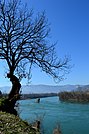
The Drina is a 346 km (215 mi) long river in the Balkans, which forms a large portion of the border between Bosnia and Herzegovina and Serbia. It is the longest tributary of the Sava River and the longest karst river in the Dinaric Alps which belongs to the Danube River drainage basin. Its name is derived from the Roman name of the river which in turn is derived from Greek.
Zaovine Lake is an artificial lake in central-west Serbia, on the Tara Mountain. It was created on the Beli Rzav river as a reservoir for the Bajina Bašta II reversible hydro power plant. The lake, with its five bays, has been nicknamed the "Jewel of Tara".
Zarožje is a village in the municipality of Bajina Bašta, in western Serbia. Located on the slopes of the Povlen mountain, Zarožje has abundance of forests and meadows, and developed agriculture and husbandry. The village, and one of its features, the watermill, are best known as the inspiration for Milovan Glišić's 1880 short story After ninety years. It featured Sava Savanović, the most famous vampire in Serbian folklore. The story was filmed in 1973 as one of the most popular Serbian horror films, Leptirica.
Lake Perućac is an artificial lake on the Drina River, on the border between Bosnia and Herzegovina and Serbia. It was created in 1966 and occupies a natural bend of the river, which encircles the Tara mountain, between towns of Višegrad in Bosnia and Bajina Bašta in Serbia.
Amor Mašović, is a Bosnian politician and Chairman of the Bosnian Federal Commission for Missing Persons. During the Bosnian War, Amor Mašović was the person responsible on the Bosnian government side for negotiating prisoner exchanges and was involved in the ultimately fruitless negotiations for the exchange of Col. Avdo Palić, the "disappeared" commander of the enclave of Žepa.
Zvijezda is a mountain on the border of Serbia and Bosnia and Herzegovina, between towns of Bajina Bašta and Višegrad. Its highest peak Veliki Stolac lies on Bosnian territory and has an elevation of 1,673 metres (5,489 ft) above sea level, followed by Kozji rid (1591m), Pivnice (1575m), Mrka kosa (1545m), and Lisnata glavica (1510m), on Serbian side. Zvijezda lies in a large bend of the Drina river, and presents a western extension of the Tara mountain. Serbian parts of the mountain belong to the Tara National Park.
The Drina Regatta is a tourist and recreational event held on the Drina River.
The Skelani massacre refers to the Army of the Republic of Bosnia and Herzegovina (ARBiH) attack on Skelani, group of villages in region of Srebrenica, Bosnia and Herzegovina, held by Army of Republika Srpska (VRS), which happened on 16 January 1993. Between 40-65 Serbs were killed in the attack.
Drina National Park is the fourth national park in Bosnia and Herzegovina, and the third in Republika Srpska. It was founded in 2017. The nearest town is Srebrenica. It is located on the other side of the Drina in relation to Tara National Park in Serbia.
This page is based on this Wikipedia article Text is available under the CC BY-SA 4.0 license; additional terms may apply. Images, videos and audio are available under their respective licenses.