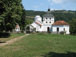
Vrane

Last updated
Vrane
Village
Serbia adm location map.svg
Red pog.svg
Vrane
Coordinates: 43°45′N19°55′E / 43.750°N 19.917°E / 43.750; 19.917
CountryFlag of Serbia.svg  Serbia
District Šumadija
Municipality Arilje
Population (2002)
  Total 775
Time zone CET (UTC+1)
  Summer (DST) CEST (UTC+2)

Vrane is a village in the municipality of Arilje, Serbia. According to the 2002 census, the village has a population of 775 people. [1]

Village Small clustered human settlement smaller than a town

A village is a clustered human settlement or community, larger than a hamlet but smaller than a town, with a population ranging from a few hundred to a few thousand. Though villages are often located in rural areas, the term urban village is also applied to certain urban neighborhoods. Villages are normally permanent, with fixed dwellings; however, transient villages can occur. Further, the dwellings of a village are fairly close to one another, not scattered broadly over the landscape, as a dispersed settlement.

Arilje Town and municipality in Šumadija and Western Serbia, Serbia

Arilje is a town and municipality located in the Zlatibor District of southwestern Serbia. The population of the town is 6,763, while the municipality has 18,792 inhabitants. The town is famous for having large raspberry plantations in which many locals are employed.

Serbia Republic in Southeastern Europe

Serbia, officially the Republic of Serbia, is a country situated at the crossroads of Central and Southeast Europe in the southern Pannonian Plain and the central Balkans. The sovereign state borders Hungary to the north, Romania to the northeast, Bulgaria to the southeast, North Macedonia to the south, Croatia and Bosnia and Herzegovina to the west, and Montenegro to the southwest. The country claims a border with Albania through the disputed territory of Kosovo. Serbia's population is about seven million. Its capital, Belgrade, ranks among the oldest and largest citiеs in southeastern Europe.

Related Research Articles

Varin District District in Siem Reap, Cambodia

Variin District is a district located in Siem Reap Province, in north-west Cambodia. According to the 1998 census of Cambodia, it had a population of 19,818.

Karan (Užice) Village in Serbia

Karan is a village in western Serbia, located in the municipality of Užice, in the Zlatibor District. According to the 2002 census, its population numbered 582. There is a 14th-century Serbian Orthodox church located in the village, called the White Church.

Goicea Comune in Romania

Goicea is a commune in Dolj County, Oltenia, Romania. Its existence was first attested in 1575. It is composed of two villages, Dunăreni and Goicea. It also included Cârna village until 2004, when it was split off to form a separate commune.

Minh Hóa is a district in Quảng Bình Province, in the North Central Coast region of Vietnam. This district is composed of one townlet and 15 communes (): Xuân Hoá, Yên Hoá, Trung Hoá, Tân Hoá, Minh Hoá, Hồng Hoá, Hóa Tiến, Hóa Hợp, Hóa Sơn, Hóa Phúc, Hóa Thanh, Dân Hoá, Thượng Hoá, Trọng Hóa, and Quy Hóa.

Vĩnh Hưng is a rural district of Long An Province in the Mekong Delta region of Vietnam. As of 2003 the district had a population of 43,777. The district covers an area of 382 km². The district capital lies at Vĩnh Hưng.

Dashtakar Place in Ararat, Armenia

Dashtakar, is a village in the Ararat Province of Armenia.

Tetoiu Commune in Vâlcea County, Romania

Tetoiu is a commune located in Vâlcea County, Romania. It is composed of seven villages: Băroiu, Budele, Măneasa, Nenciulești, Popești, Tetoiu and Țepești.

Redczyce Village in Kuyavian-Pomeranian, Poland

Redczyce is a village in the administrative district of Gmina Żnin, within Żnin County, Kuyavian-Pomeranian Voivodeship, in north-central Poland. It lies approximately 9 kilometres (6 mi) north-east of Żnin and 28 km (17 mi) south-west of Bydgoszcz.

Odletajka Village in Lublin, Poland

Odletajka is a village in the administrative district of Gmina Uchanie, within Hrubieszów County, Lublin Voivodeship, in eastern Poland. It lays approximately 9 kilometres (6 mi) east of Uchanie, 15 km (9 mi) north-west of Hrubieszów, and 91 km (57 mi) south-east of the regional capital Lublin.

Pietrzaki Village in Silesian, Poland

Pietrzaki is a village in the administrative district of Gmina Herby, within Lubliniec County, Silesian Voivodeship, in southern Poland. It lies approximately 19 kilometres (12 mi) north-east of Lubliniec and 56 km (35 mi) north of the regional capital Katowice.

Stare Włóki Village in Warmian-Masurian, Poland

Stare Włóki is a village in the administrative district of Gmina Barczewo, within Olsztyn County, Warmian-Masurian Voivodeship, in northern Poland. It lies approximately 11 kilometres (7 mi) north-east of Barczewo and 23 km (14 mi) north-east of the regional capital Olsztyn.

Ruhayqah is a village in west-central Yemen. It is located in the San‘a’ Governorate.

Karali is a village in Gabrovo Municipality, in Gabrovo Province, in northern central Bulgaria.

Lohovo Village in Bihać, Bosnia and Herzegovina

Lohovo is a village in the municipality of Bihać, Bosnia and Herzegovina.

Nihka is a village in Lääne-Nigula Parish, Lääne County, in western Estonia.

Mohare is a village in Belgaum district of Karnataka, India.

Bogilice Village in Republika Srpska, Bosnia and Herzegovina

Bogilice is a village in the municipality of Višegrad, Bosnia and Herzegovina.

Oplave Village in Republika Srpska, Bosnia and Herzegovina

Oplave is a village in the municipality of Višegrad, Bosnia and Herzegovina.

Rujišta Village in Republika Srpska, Bosnia and Herzegovina

Rujišta is a village in the municipality of Višegrad, Bosnia and Herzegovina.

Amran District is a district of the 'Amran Governorate, Yemen. As of 2003, the district had a population of 96,375 inhabitants. The capital lies at `Amran.

References

  1. Popis stanovništva, domaćinstava i Stanova 2002. Knjiga 1: Nacionalna ili etnička pripadnost po naseljima. Republika Srbija, Republički zavod za statistiku Beograd 2003. ISBN   86-84433-00-9

Coordinates: 43°45′N19°55′E / 43.750°N 19.917°E / 43.750; 19.917

Geographic coordinate system Coordinate system

A geographic coordinate system is a coordinate system that enables every location on Earth to be specified by a set of numbers, letters or symbols. The coordinates are often chosen such that one of the numbers represents a vertical position and two or three of the numbers represent a horizontal position; alternatively, a geographic position may be expressed in a combined three-dimensional Cartesian vector. A common choice of coordinates is latitude, longitude and elevation. To specify a location on a plane requires a map projection.