State Road 47 (Serbia)

Last updated
M47-SRB.svg
State Road 47
Serbian: Državni put IB reda 47
Serbian Cyrillic: Државни пут IБ реда 47
State Road 47 map.png
Route information
Part of E70-SRB.svg E70
Maintained by JP "Putevi Srbije"
Length4.727 km (2.937 mi)
Major junctions
From Belgrade (printing company) M10-SRB.svg M13-SRB.svg
ToBelgrade (Bogoslovija)
Location
Country Serbia
Districts City of Belgrade
Highway system
M46-SRB.svg 46 M10-SRB.svg 10
B47-SRB.svg
Expressway 47
Serbian: Brzi put 47
Serbian Cyrillic: Брзи пут 47
Expressway 47 map.png
Route information
Part of E70-SRB.svg E70
Maintained by JP "Putevi Srbije"
Length2.475 km (1.538 mi)
Major junctions
From Belgrade (printing company) M10-SRB.svg M13-SRB.svg
To Krnjača interchange M47-SRB.svg
Location
Country Serbia
Districts City of Belgrade
Highway system
B24-SRB.svg Expressway 24 B10-SRB.svg Expressway 10

State Road 47 is an IB-class road in northern Serbia, connecting the Bogoslovija neighborhood of Belgrade with a printing company on the left side of Danube river. It is located in the City of Belgrade. [1]

Contents

Before the new road categorization regulation given in 2013, the route wore the following names: M 1.9 (before 2012) / A3 (after 2012). [2] [3]

The existing route is a main road with four traffic lanes, while the Belgrade (printing company) – Krnjača interchange (Pančevo bridge) section has been built by expressway standards. By the valid Space Plan of Republic of Serbia the road is planned for transferring to the new motorway, which would go side-by-side with the State Road 10. [4]

The road is a part of European route E70.

Sections

Section numberLengthDistanceSection name
047012.252 km (1.399 mi)2.252 km (1.399 mi) Belgrade (printing company) – Krnjača interchange
047022.475 km (1.538 mi)4.727 km (2.937 mi)Krnjača interchange – Belgrade (Bogoslovija)

Planned motorway

By the valid Space Plan of Republic of Serbia the motorway construction is planned side-by-side with the existing National Road IB-10. The given section would start at Belgrade bypass (which would include Pančevo from the "Pančevo-north" interchange), and end at the border with Romania. The planned highway would go south of existing route until Alibunar, and then north until Vatin, where it would be connected with Romanian road network. By that, the existing section would be shortened.

See also

Related Research Articles

<span class="mw-page-title-main">State Road 10 (Serbia)</span> Road in Serbia

State Road 10, or referred to as Belgrade – Vatin road, is state road, class I-b/expressway in northern Serbia, connecting Belgrade with Romania at Vatin border crossing. It runs through the southern Banat region.

<span class="mw-page-title-main">State Road 12 (Serbia)</span> Road in Serbia

State Road 12, is an IB-class road in northern Serbia, connecting Subotica with Romania. It is located in Vojvodina.

<span class="mw-page-title-main">State Road 13 (Serbia)</span> Road in Serbia

State Road 13, is an IB-class road, located in northern Serbia, connecting Horgoš with Belgrade. It is located in Vojvodina and City of Belgrade.

<span class="mw-page-title-main">State Road 14 (Serbia)</span> Road in Serbia

State Road 14, is an IB-class road in northern and eastern Serbia, connecting Pančevo with Ralja. It is located in Vojvodina and Southern and Eastern Serbia regions.

<span class="mw-page-title-main">State Road 15 (Serbia)</span> Road in Serbia

State Road 15, is an IB-class road in northern Serbia, connecting Hungary at Bački Breg with Romania at Nakovo. It is located in Vojvodina.

<span class="mw-page-title-main">State Road 16 (Serbia)</span> Road in Serbia

State Road 16, is an IB-class road in northern Serbia, connecting Croatia at Bezdan with State Road 15. It is located in Vojvodina.

<span class="mw-page-title-main">State Road 18 (Serbia)</span> Road in Serbia

State Road 18, is an IB-class road in northern Serbia, connecting Zrenjanin with Romania at Kaluđerovo. It is located in Vojvodina.

<span class="mw-page-title-main">State Road 21 (Serbia)</span> Road in Serbia

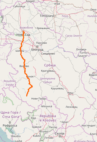
State Road 21 is an IB-class road in northern and western Serbia, connecting Novi Sad with Sjenica. It is in Vojvodina and Šumadija and Western Serbia regions.

<span class="mw-page-title-main">State Road 23 (Serbia)</span> Road in Serbia

State Road 23, from Čačak via Zlatibor commonly known as Zlatibor Highway, is an IB-class road in central and western Serbia, connecting Pojate with Montenegro at Gostun. It is located in Šumadija and Western Serbia.

<span class="mw-page-title-main">State Road 25 (Serbia)</span> Road in Serbia

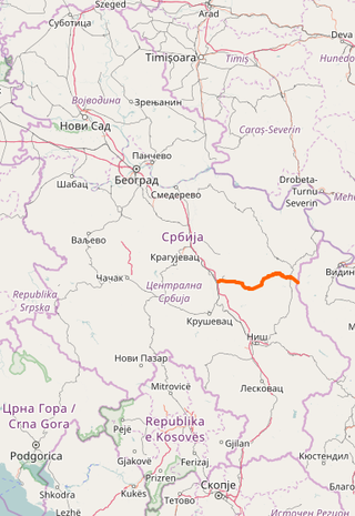
State Road 25 is an IB-class road in northern and central Serbia, connecting Mali Požarevac with Kragujevac. It is located in Belgrade and Šumadija and Western Serbia regions.

<span class="mw-page-title-main">State Road 26 (Serbia)</span> Road in Serbia

State Road 26 is an IB-class road in northern and central Serbia, connecting Belgrade with Bosnia and Herzegovina at Mali Zvornik. It is located in Belgrade and Šumadija and Western Serbia regions.

<span class="mw-page-title-main">State Road 27 (Serbia)</span> Road in Serbia

State Road 27 is an IB-class road in western, northern, central and eastern Serbia, connecting Bosnia and Herzegovina at Trbušnica with Svilajnac. It is located in Šumadija and Western Serbia, Belgrade and Southern and Eastern Serbia regions.

<span class="mw-page-title-main">State Road 29 (Serbia)</span> Road in Serbia

State Road 29 is an IB-class road in western Serbia, connecting Montenegro at Jabuka with Novi Pazar. It is located in Šumadija and Western Serbia.

<span class="mw-page-title-main">State Road 32 (Serbia)</span> Road in Serbia

State Road 32 is an IB-class road in southwestern Serbia and Kosovo, connecting Ribariće with Mitrovica.

<span class="mw-page-title-main">State Road 34 (Serbia)</span> Road in Serbia

State Road 34 is an IB-class road in eastern Serbia, connecting Požarevac with HE Đerdap I. It is located in Southern and Eastern Serbia.

<span class="mw-page-title-main">State Road 35 (Serbia)</span> Road in Serbia

State Road 35 is an IB-class road in southeastern Serbia and Kosovo, connecting Romania at HE Đerdap I with Albania at Vërmica.

<span class="mw-page-title-main">State Road 36 (Serbia)</span> Road in Serbia

State Road 36 is an IB-class road in western and eastern Serbia, connecting Paraćin with Bulgaria at Vrška Čuka. It is located in Šumadija and Western Serbia and Southern and Eastern Serbia regions.

<span class="mw-page-title-main">State Road 39 (Serbia)</span> Road in Serbia

State Road 39 is an IB-class road in southeastern Serbia and Kosovo, connecting Pirot, Serbia with Montenegro at Čakor.

<span class="mw-page-title-main">State Road 40 (Serbia)</span> Road in Serbia

State Road 40 is an IB-class road in southern Serbia, connecting Vladičin Han with Bulgaria at Strezimirovci. It is located in Southern and Eastern Serbia.

<span class="mw-page-title-main">State Road 41 (Serbia)</span> Road in Serbia

State Road 41 is an IB-class road in southern Serbia and Kosovo, connecting Bujanovac with Štimlje.

References

  1. "Republic of Serbia – national road network" (PDF). Putevi Srbije (in Serbian).
  2. "National road categorization regulation – Official Gazette of Republic of Serbia no. 105/2013 and 119/2013" (PDF). Serbian Spatial Planners Association (in Serbian).
  3. "Link between actual and previous section and road markings" (PDF). Putevi Srbije (in Serbian).
  4. Space plan of Republic of Serbia from 2010 to 2021