Grand Forks County is a county in the U.S. state of North Dakota. As of the 2010 United States Census, its population was 66,861, making it the third-most populous county in North Dakota. Its county seat and largest community is Grand Forks.
The Darling Scarp, also referred to as the Darling Range or Darling Ranges, is a low escarpment running north-south to the east of the Swan Coastal Plain and Perth, Western Australia. The escarpment extends generally north of Bindoon, to the south of Pemberton. The adjacent Darling Plateau goes easterly to include Mount Bakewell near York and Mount Saddleback near Boddington. It was named after the Governor of New South Wales Lieutenant-General Ralph Darling.

Dar al-Manasir is the region of the Fourth Cataract, the most impassable of all rapids of the Nile. It is the homeland of the Arab tribe of the Manasir and from them gets its name. Still today the water rapids cannot be crossed by any large boats making the region accessible only via a sandy and rocky desert track.

Greater Caucasus is the major mountain range of the Caucasus Mountains.
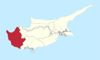
This is a list of the extreme points of Cyprus: the points that are farther north, south, east or west than any other location.
The Mangangate River, also referred to as the Alabang-Cupang River, is a river system in Muntinlupa, Philippines. It is one of 21 major tributaries of Laguna de Bay.
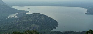
Aliyar (ஆழியாறு) (also spelt Azhiyar / Aaliyar) Reservoir is a 6.48 km2 (2.5 sq mi) reservoir located in Aliyar village near Pollachi town in Coimbatore District, Tamil Nadu, South India. The dam is located in the foothills of Valparai, in the Anaimalai Hills of the Western Ghats. It is about 65 kilometres (40 mi) from Coimbatore. The dam offers some ideal getaways including a park, garden, aquarium, play area and a mini Theme-Park maintained by Tamil Nadu Fisheries Corporation for visitors enjoyment. The scenery is beautiful, with mountains surrounding three quarters of the reservoir. Boating is also available.

The Okutataragi Pumped Storage Power Station is a large pumped-storage hydroelectric power station in Asago, in the Hyōgo Prefecture of Japan. With a total installed capacity of 1,932 megawatts (2,591,000 hp), it is one of the largest pumped-storage power stations in the world, and the largest in Japan. The facility is currently run by the Kansai Electric Power Company.

Germany is a country in west-central Europe, that stretches from the Alps, across the North European Plain to the North Sea and the Baltic Sea. Germany has the second largest population in Europe and is seventh largest in area. The territory of Germany covers 357,021 km2 (137,847 sq mi), consisting of 349,223 km2 (134,836 sq mi) of land and 7,798 km2 (3,011 sq mi) of waters.
Stroumpi or Stroumbi is a small village in central Paphos District, Cyprus, and halfway between Paphos and Polis. The name of the village is said to derive from its founder, a man called "Stroumpos", or the shape of the surrounding hills. The village is known for its annual "Dionysia" wine festival named after Dionysos, the ancient Greek god of wine, that takes place at the end of August. A now-defunct "Dionysos" volleyball team was based in Stroumpi and played in the Cypriot top league.
Berdan Dam is an embankment dam on the Berdan River in Mersin Province, Turkey. It was built between 1975 and 1984. It supports a 10 MW power station and provides water for the irrigation of 27,050 hectares.
Süreyyabey Dam is a dam on the Çekerek River in Yozgat Province, Turkey. The development was backed by the Turkish State Hydraulic Works.
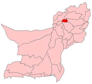
Ziarat is a district in the north of Balochistan province of Pakistan. Ziarat town is headquarters of the district of the Sub division, and also of the tehsil. Khalifat Hills have the highest peak with an altitude of 11,400 feet (3,500 m) in Ziarat district.
The Chrysochou is a river of Paphos District in western Cyprus. It flows through the Paphos Forest and village of Goudi. One of its tributaries is the Stavros tis Psokas. The main aquifers of the basin are The Terra and Koronia Limestones, The Gypsum, The Coastal Plain, and The Alluvial.

Cherangani Hills Forest is a collection of thirteen forest reserve blocks in western Kenya, located in the Cherangani Hills on the western ridge of the East African Rift. The forested area is about 1,200 square kilometres (463 sq mi), 956 square kilometres (369 sq mi) of which has been gazetted into forest reserves. These forest reserves form the upper catchments of the Kerio and Nzoia and Turkwel rivers.
Gwaldi is an administrative unit known as “Union Council” of Upper Dir District in the Khyber Pakhtunkhwa province of Pakistan.

Akçay Dam is a dam in Turkey. It is on Akçay River which is a tributary of Sakarya River.