
Armenia is a landlocked country in the Transcaucasia region, between the Black and Caspian Seas, bordered on the north and east by Georgia and Azerbaijan and on the south and west by Iran and Turkey.

The Ordos Desert, also known as the Muu-us or Bad Water Desert, is a desert and steppe region lying on a plateau in the south of the Inner Mongolian Autonomous Region of the People's Republic of China. The soil of the Ordos is a mixture of clay and sand and, as a result, is poorly suited for agriculture. It extends over an area of approximately 90,650 km2 (35,000 sq mi). It comprises two large deserts: the 7th largest desert in China, the Kubuqi Desert in the north, and the 8th largest desert in China, the Muu-us Desert, in the south.

The Ağrı Province is a province in eastern Turkey, bordering Iran to the east, Kars to the north, Erzurum to the northwest, Muş and Bitlis to the southwest, Van to the south, and Iğdır to the northeast. It has an area of 11,376 km² and a population of 542,022. A majority of the province's population is Kurdish. The region also has got a sizeable Azerbaijani (Qarapapak) minority.

The Usarp Mountains is a major Antarctic mountain range, lying westward of the Rennick Glacier and trending N-S for about 190 kilometres (118 mi). The feature is bounded to the north by Pryor Glacier and the Wilson Hills. Its important constituent parts include Welcome Mountain, Mount Van der Hoeven, Mount Weihaupt, Mount Stuart, Mount Lorius, Smith Bench, Mount Roberts, Pomerantz Tableland, Daniels Range, Emlen Peaks, Helliwell Hills and Morozumi Range.
The R353 is a Regional Route in South Africa that connects Leeu-Gamka with Brandvlei via Fraserburg and Williston.

The Tropidostoma Assemblage Zone is a tetrapod assemblage zone or biozone which correlates to the lower Teekloof Formation, Adelaide Subgroup of the Beaufort Group, a fossiliferous and geologically important geological Group of the Karoo Supergroup in South Africa. The thickest outcrops, reaching approximately 240 metres (790 ft), occur from east of Sutherland through to Beaufort West and Victoria West, to areas south of Graaff-Reinet. Its northernmost exposures occur west/north-west of Colesberg. The Tropidostoma Assemblage Zone is the fourth biozone of the Beaufort Group.

Otavi is a town of 4,000 inhabitants in the Otjozondjupa Region of central Namibia. Situated 360km north of Windhoek, it is the district capital of the Otavi electoral constituency. Most of the area is dolomitic (Precambrian) and the district was in the past renowned for its mineral wealth. Most of the deposits have now been exhausted.

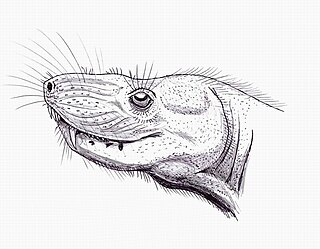
Moschowhaitsia is an extinct genus of therocephalian theriodonts. It was among the larger carnivores in the faunal assemblages it occurred in.
Elliotsmithia is a small varanopseid synapsid found from the late Middle Permian of South Africa. It is the sole basal synapsid "pelycosaur" known from the supercontinent Gondwana and only two specimens have been yielded to date. Its species name longiceps is derived from Latin, meaning "long head". Both known Elliotsmithia fossils were recovered from Abrahamskraal Formation rocks—within the boundaries of the Tapinocephalus Assemblage Zone—of the lower Beaufort Group.
Ictidostoma is an extinct genus of non-mammalian synapsids.
Hofmeyria is an extinct genus of therocephalians.

Viatkosuchus is an extinct genus of therocephalians.
The Paddys River, a perennial river that is part of the Hawkesbury-Nepean catchment, is located in the Southern Highlands region of New South Wales, Australia.

The De Berg Pass was opened in 1988, and is situated on the R577 road between Lydenburg and Roossenekal, in Mpumalanga, South Africa. It is the highest pass in Mpumalanga, and skirts the southern slopes of De Berg, the highest point of the Steenkampsberg.

The borders of the oceans are the limits of the Earth's oceanic waters. The definition and number of oceans can vary depending on the adopted criteria.
Mount Bumstead is a large, isolated mountain, 3,200 metres (10,500 ft) high, standing 10 nautical miles (19 km) southeast of Otway Massif in the Grosvenor Mountains in Antarctica. It was discovered by R. Admiral Byrd on the Byrd Antarctic Expedition flight to the South Pole in November 1929 and named by him for Albert H. Bumstead, chief cartographer of the National Geographic Society at that time, and inventor of the sun compass, a device utilizing shadows of the sun to determine directions in areas where magnetic compasses are unreliable.

The Takitimu Mountains extend in a north-south direction southeast of Te Anau and Manapouri. The mountain range is about 30 kilometres (19 mi) long and contains several peaks of around 1,600 metres (5,200 ft) height, with the Brunel Peaks reaching 1,650 metres (5,410 ft).

The Teekloof Formation is a geological formation that forms part of the Beaufort Group, one of the five geological groups that comprises the Karoo Supergroup in South Africa. The Teekloof Formation is the uppermost formation of Adelaide Subgroup deposits West of 24ºE and contains Middle to Late Permian-aged deposits and four biozones of the Beaufort Group. It overlies the Abrahamskraal Formation. The Teekloof Formation does not underlie other units other than the younger Karoo dolerites and sills that relate to the emplacement of the Early Jurassic Drakensberg Group to the east. Outcrops and exposures of the Teekloof Formation range from Sutherland through the mountain escarpments between Fraserburg and Beaufort West. The northernmost localities of the Teekloof Formation are found by Loxton, Victoria West and Richmond.


