
The Drakensberg is the eastern portion of the Great Escarpment, which encloses the central Southern African plateau. The Great Escarpment reaches its greatest elevation – 2,000 to 3,482 metres within the border region of South Africa and Lesotho.
Dullstroom, also known as Emnothweni, is a small town in Mpumalanga province, South Africa. The town lies 35 kilometres north of Belfast and some 53 kilometres south-west of Lydenburg on the R540 road.

The Highveld is the portion of the South African inland plateau which has an altitude above roughly 1,500 m (4,900 ft), but below 2,100 m (6,900 ft), thus excluding the Lesotho mountain regions to the south-east of the Highveld. It is home to some of the country's most important commercial farming areas, as well as its largest concentration of metropolitan centres, especially the Gauteng conurbation, which accommodates one-third of South Africa's population.

The Berg River is a river located just north of Cape Town in the Western Cape Province of South Africa. It is approximately 294 km (183 mi) long with a catchment area of 7,715 km2 (2979 mi2) and empties into the Atlantic Ocean. About 65% of the Berg River area is under agriculture. The major towns in the Berg River area are Velddrif and Laaiplek near the coast, and Piketberg, Hopefield, Moorreesburg and Darling further inland.

The Scandinavian montane birch forests and grasslands is defined by the World Wildlife Fund (WWF) as a terrestrial tundra ecoregion in Norway, Sweden, and Finland.
The wildlife of Iraq includes its flora and fauna and their natural habitats. Iraq has multiple biomes from mountainous region in the north to the wet marshlands along the Euphrates river. The western part of the country is mainly desert and some semi-arid regions. As of 2001, seven of Iraq's mammal species and 12 of its bird species were endangered. The endangered species include the northern bald ibis and Persian fallow deer. The Syrian wild ass is extinct, and the Saudi Arabian dorcas gazelle was declared extinct in 2008.

The wildlife of South Africa consists of the flora and fauna of this country in Southern Africa. The country has a range of different habitat types and an ecologically rich and diverse wildlife, vascular plants being particularly abundant, many of them endemic to the country. There are few forested areas, much savanna grassland, semi-arid Karoo vegetation and the fynbos of the Cape Floristic Region. Famed for its national parks and big game, 297 species of mammal have been recorded in South Africa, as well as 849 species of bird and over 20,000 species of vascular plants.

The Central Andean dry puna (NT1001) is an ecoregion in the montane grasslands and shrublands biome, located in the Andean Altiplano in South America. It is a part of the Puna grassland.

Abe Bailey Nature Reserve is a protected area in the Merafong City Local Municipality in Gauteng, South Africa. It is situated near Carletonville, beside the township of Khutsong on the West Rand. It is about 4,200 hectares in size.
Blyde River Canyon Nature Reserve is situated in the Drakensberg escarpment region of eastern Mpumalanga, South Africa. The reserve protects the Blyde River Canyon, including sections of the Ohrigstad and Blyde Rivers and the geological formations around Bourke's Luck Potholes, where the Treur River tumbles into the Blyde below. Southwards of the canyon, the reserve follows the escarpment, to include the Devil's and God's Window, the latter a popular viewpoint to the lowveld at the reserve's southern extremity.
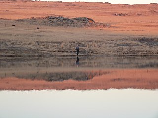
Verloren Valei Nature Reserve is a protected area in Mpumalanga, South Africa. One of the few places in the country to breed the three species cranes present in South Africa, the Verloren Vallei Nature Reserve lies roughly 13 km (8.1 mi) outside Dullstroom, a beautiful, peaceful part of the Steenkampsberg plateau that includes rolling grasslands and sensitive wetlands.
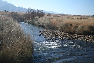
The Crocodile River, also referred to as Crocodile River (East), (Afrikaans: Krokodilrivier) is a large river traversing Mpumalanga province of South Africa. It is a tributary of the Komati River.
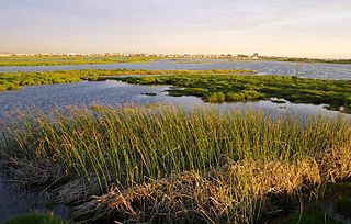
The Rietvlei Wetland Reserve is a 663-hectare (1,640-acre) nature reserve situated in Table View, Western Cape, South Africa. It is managed by the City of Cape Town's Environmental Resource Management Department.

Ts'ehlanyane National Park is a National Park in Lesotho. It is located in the Maloti Mountains in Leribe District, and is part of the larger Maloti-Drakensberg Transfrontier Conservation Area. This Lesotho northern park protects a high-altitude, 2,600-metre (8,500 ft) patch of rugged wilderness, including one of Lesotho’s only stands of indigenous forest with a number of rare undergrowth plants that are unique to this woodland habitat.

Tanzania contains some 20 percent of the species of Africa's large mammal population, found across its reserves, conservation areas, marine parks, and 17 national parks, spread over an area of more than 42,000 square kilometres (16,000 sq mi) and forming approximately 38 percent of the country's territory. Wildlife resources of Tanzania are described as "without parallel in Africa" and "the prime game viewing country". Serengeti National Park, the country's second largest national park area at 14,763 square kilometres (5,700 sq mi), is located in northern Tanzania and is famous for its extensive migratory herds of wildebeests and zebra while also having the reputation as one of the great natural wonders of the world. The Ngorongoro Conservation Area, established in 1959, is a UNESCO World Heritage Site and inhabited by the Maasai people. Its Ngorongoro Crater is the largest intact caldera in the world.
The Guassa Community Conservation Area (GCCA) is a protected area in central Ethiopia. It is one of the oldest known common property resource management in Sub-Saharan Africa. It has been the focus of an indigenous natural resource management institution, known as “Qero,” system for over 400 years It is located 80 km off the main highway, and is home to numerous endemic birds and wildlife species, including the iconic Ethiopian wolf and the Ethiopian gelada. The high altitude Afro-alpine Festuca grassland, or ‘Guassa” grass gives the area its name.

The wildlife of Chechnya includes a range of flora, fauna, and funga as reflected by its varying topographic and climatic conditions, with the Greater Caucasus to the south, the foreland zone the Terek and Sunza river valleys in the west and east, and the rolling plains of Nogai steppe in the north. Lake Kezenoyam in Chechnya is near the border with Dagestan and can sustain plankton growth. Salmo ezenami, a rare species of trout now critically endangered due to introduction of the invasive species European chub, is native only to this lake and is therefore endemic to Lake Kezenoyam.
Ntsikeni Nature Reserve, in Griqualand East, is the largest wetland and one of the highest above sea level in South Africa.
The Wonderfonteinspruit is a small river situated in the Highveld region of South Africa. Its source has been disputed in the past, although it is now accepted that the river originates in the West Rand of Gauteng between Krugersdorp and Randfontein, at the Tudor Dam, which was initially used as a storage dam for the Luiperdsvlei Gold Plant. In the past the river received a majority of its water from karst springs along its course. The river flows through one of the richest gold-producing areas in the world, which led to the dolomitic compartments which fed the river being dewatered to make way for mining activities. This led to the drying up of the karst springs that fed the river.
Arsi Mountains National Park is a national park in Arsi Zone of Oromia Region in Ethiopia. It protects a portion of the Ethiopian Highlands, and includes montane forests, subalpine heath, and alpine grasslands and shrublands. The park was designated in 2011, and covers an area of 10876 km2.


