The Black Forest is a large forested mountain range in south-west Germany, in the state of Baden-Württemberg, bounded by the Rhine valley to the west and south. It is the source of the Danube and Neckar rivers.

Rhineland-Palatinate is a western state of Germany. It covers 19,846 km2 (7,663 sq mi) and has about 4.05 million residents. It is the ninth largest and sixth most populous of the sixteen states. Mainz is the capital and largest city. Other cities are Ludwigshafen am Rhein, Koblenz, Trier, Kaiserslautern and Worms. It is bordered by North Rhine-Westphalia, Saarland, Baden-Württemberg and Hesse and by the countries France, Luxembourg and Belgium.

Karlsruhe is the second-largest city of the German federal state of Baden-Württemberg after its capital of Stuttgart, and its 313,092 inhabitants make it the 21st largest city of Germany. On the right bank of the Rhine, the city lies near the French-German border, between the Mannheim/Ludwigshafen conurbation to the north, and the Strasbourg/Kehl conurbation to the south. It is the largest city of Baden, a historic region named after Hohenbaden Castle in the city of Baden-Baden. Karlsruhe is also the largest city in the South Franconian dialect area, the only other larger city in that area being Heilbronn. The city is the seat of the Federal Constitutional Court (Bundesverfassungsgericht), as well as of the Federal Court of Justice (Bundesgerichtshof) and the Public Prosecutor General of the Federal Court of Justice.
Breisgau-Hochschwarzwald is a Landkreis (district) in the southwest of Baden-Württemberg, Germany. Fifty towns and municipalities with 133 settlements lie within the district. The district itself belongs to the province of Freiburg with the region of Southern Upper Rhine.

Bingen am Rhein is a town in the Mainz-Bingen district in Rhineland-Palatinate, Germany.

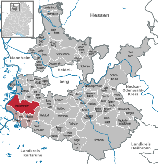
Hockenheim is a town in northwest Baden-Württemberg, Germany, about 20 km south of Mannheim and 10 km west of Walldorf. It is located in the Upper Rhine valley on the tourist theme routes "Baden Asparagus Route" and Bertha Benz Memorial Route. The town is widely known for its Hockenheimring, a motor racing course, which has hosted over 30 Formula One German Grand Prix races since 1970.

The Rhine-Neckar Metropolitan Region, often referred to as Rhein-Neckar-Triangle is a polycentric metropolitan region located in south western Germany, between the Frankfurt/Rhine-Main region to the North and the Stuttgart Region to the South-East.

The Bergstraße is 80-kilometre-long (50 mi) ancient trade route in the south-west of Germany. The route and the area around it is a mountainous "theme route" running north–south along the western edge of the Odenwald forest in southern Hesse and northern Baden-Württemberg. The route passes through the Bergstraße administrative district, and independent viticultural regions of Hessische Bergstraße and Badische Bergstraße. Between the cities of Heidelberg and Weinheim the Upper Rhine Railway Company (OEG) tram route runs alongside.

Elchesheim-Illingen is a village in southwestern Germany, located between Karlsruhe and Rastatt. The Rhine flows 5 km west of the village.

Weil am Rhein is a German town and commune. It is on the east bank of the River Rhine, and extends to the point at which the Swiss, French and German borders meet. It is the most southwesterly town in Germany and a suburb of the Swiss city Basel. Weil am Rhein is part of the "trinationale Agglomeration Basel" with about 830,000 inhabitants.

Kandern is a town in southwestern Germany in the state of Baden-Württemberg, in the Kreis (district) of Lörrach. During the Battle of Schliengen, in which the French Revolutionary army fought the forces of Austria, the battle lines of both armies ended in Kandern. It is not far from a tripoint called the "Three-Country Corner" (Dreiländereck), where the three countries Germany, France and Switzerland meet and is one of the smallest cities in Germany.

Hemsbach is a town with approximately 12,000 inhabitants in the Rhein-Neckar-Kreis of Baden-Württemberg, Germany. It belongs to the European Rhine-Neckar Metropolitan Region. It is situated on the Bergstraße, 18 km northeast of Mannheim. Hemsbach was twinned with Wareham, Dorset in the UK in 1986.

Neuenburg am Rhein is a town in the district Breisgau-Hochschwarzwald in Baden-Württemberg in southern Germany.

Mauer is a village in south western Germany. It is located between Heidelberg and Sinsheim in the Rhein-Neckar district in the state of Baden-Württemberg.

Kirchardt is a town in the district of Heilbronn in Baden-Württemberg, Germany.

Baden is a region (Anbaugebiet) for quality wine in Germany, and is located in the historical region of Baden in southwestern Germany, which today forms part of the federal state of Baden-Württemberg. Under German wine legislation, Baden and Württemberg are separate wine regions.

The Schwarzwaldhochstraße or Black Forest High Road is the oldest and one of the best known themed drives in Germany. It is a part of the B 500 federal highway and leads over 60 km from Baden-Baden to Freudenstadt.

Altschweier is a German village to the east of the town of Bühl (Baden). It is located in the Büllot valley on both sides of the Büllot creek extending into the foothills of the Black Forest mountain range. The population of Altschweier is about 2000.

The Danube is conventionally taken to be formed by the confluence of the two streams Brigach and Breg just east of Donaueschingen. The source of the Donaubach, which flows into the Danube, in Donaueschingen is often referred to as the source of the Danube (Donauquelle). Hydrologically, the source of the Danube is the source of the Breg as the larger of the two formative streams which rises near Furtwangen.


