Stevensweert

Last updated
Stevensweert
Village
Stevensweert, de Sint Stephanuskerk RM34890 en de pastorie RM34891 foto4 2017-05-10 14.15.jpg
St Stephanus Church and the presbytery
Stevensweert wapen.svg
Netherlands location map.svg
Red pog.svg
Stevensweert
Location in the Netherlands
2010-NL-P11-Limburg-positiekaart-gemnamen.jpg
Red pog.svg
Stevensweert
Location in the province of Limburg in the Netherlands
Coordinates: 51°07′50″N5°50′45″E / 51.13056°N 5.84583°E / 51.13056; 5.84583 Coordinates: 51°07′50″N5°50′45″E / 51.13056°N 5.84583°E / 51.13056; 5.84583
Country Netherlands
ProvinceLimburg
Municipality Maasgouw
Area
[1]
  Total7.39 km2 (2.85 sq mi)
Elevation
[2]
26 m (85 ft)
Population
 (2021) [1]
  Total1,610
  Density220/km2 (560/sq mi)
Time zone UTC+1 (CET)
  Summer (DST) UTC+2 (CEST)
Postal code
6107 [1]
Dialing code 0475

Stevensweert is a village in the Dutch province of Limburg. It is located in the municipality of Maasgouw. It lies on the right bank of the river Meuse, which forms the border with Kessenich in Belgium. There was also a ferry to this village. [3]

Contents

History

The village was first mentioned in 1221 as in Werde, and means "land near water dedicated to Saint Stephen". [4]

With Ohé en Laak, Stevensweert is situated on an island in the Meuse. [5] The Spanish built a fortress in 1633 during the Eighty Years War, [4] this is still apparent in the street plan of the town. Stevensweert once was part of the Duchy of Guelders. In 1702, it was conquered by the Dutch Republic. [5]

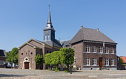
The Catholic St Stephanus is a cruciform church built in 1781 as a replacement of the 13th century church. It was damaged in 1944 and 1945, and restored and enlarged by Pierre Cuypers jr.  [ nl ]. The church contains a Roman baptismal font from around 1200. The Dutch Reformed church is a little aisleless church built in 1822. In 1951, the war damage was repaired. [5]

The grist mill Hompesche Molen was built in 1722 as part of the castle complex, and is the only remaining part. [6] The top of the sail measures 37 metres (121 ft) making it the tallest wind mill in the province of Limburg. [7] In October 1944, it was hit several times by British artillery from the liberated Belgian side. The wind mill was restored between 1948 and 1949. In the 1950s, the mill went out of service. Between 1975 and 1977, it was restored and returned to occassional service. The barn next to the mill contains a brasserie. [6]

Stevensweert was home to 600 people in 1840. It was an independent municipality until 1991 when it was merged into Maasbracht. In 2007, it became part of the municipality of Maasgouw. [7]

Related Research Articles

Ottersum Village in Limburg, Netherlands

Ottersum is a village in the Dutch province of Limburg. It is a part of the municipality of Gennep, and lies about 17 km southeast of Nijmegen.

Kessenich Village in Flanders

Kessenich is a village in the Belgian province Limburg. It is a section of the municipality of Kinrooi, lying in the eastern end of the municipality.

Linne Village in Limburg, Netherlands

Linne is a village in the Dutch province of Limburg. It is a part of the municipality of Maasgouw, and lies about 6 km southwest of Roermond.

Wessem Small city in Limburg, Netherlands

Wessem is a small city in the Netherlands, in the province of Limburg. Wessem is a part of the municipality of Maasgouw. It received city rights around 1320.

Baexem Village in Limburg, Netherlands

Baexem is a village in the Dutch province of Limburg. It is a part of the municipality of Leudal, and lies about 9 kilometres northwest of Roermond.

Horn, Netherlands Village in Limburg, Netherlands

Horn is a village in the Dutch province of Limburg. It is a part of the municipality of Leudal, and lies about 5 km northwest of Roermond.

Biggekerke Village in Zeeland, Netherlands

Biggekerke is a village in the Dutch province of Zeeland. It is a part of the municipality of Veere, and lies about 6 km northwest of Vlissingen.

Hoedekenskerke Village in Zeeland, Netherlands

Hoedekenskerke is a village in the Dutch province of Zeeland. It is a part of the municipality of Borsele, and lies about 22 km east of Middelburg.

Ohé en Laak Village in Limburg, Netherlands

Ohé en Laak is a village in the province of Limburg, Netherlands, which has been subsumed into the municipality of Maasgouw. The village used to be home to several castles, one of which is Hasseltholt which is popularly called "Het Geudje". The other was the castle of Walburg. This castle was ruined and is fully removed now. The soccer team is called Walburgia. Furthermore, there is a renovated windmill called "De Hompesche molen". In the past this windmill was used for milling wheat and corn flower. The village of Ohé en Laak has got a nice yacht harbour at the river Maas and currently there are three campsites. The majority of the inhabitants are Roman Catholics, there is a church called "Onze Lieve Vrouw Geboorte" and a chapel called "Sint Anna-kapel".

Almkerk Village in North Brabant, Netherlands

Almkerk is a village in the municipality of Altena, in the Netherlands. It is located about 7 km south of Gorinchem.

Maasgouw Municipality in Limburg, Netherlands

Maasgouw is a municipality in the Dutch province of Limburg. It is located on both banks of the river Meuse southwest of the city of Roermond. It was formed in a merger of the former municipalities of Heel, Maasbracht and Thorn on 1 January 2007.

Retranchement Village in Zeeland, Netherlands

Retranchement is a village in the Dutch province of Zeeland. It is located on the Belgian border, about 9 km northwest of Oostburg, in the municipality of Sluis.

Zuidzande Village in Zeeland, Netherlands

Zuidzande is a village in the Dutch province of Zeeland. It is located in the municipality of Sluis.

Grathem Village in Limburg, Netherlands

Grathem is a village in the Dutch province of Limburg. It is located in the municipality of Leudal, about 10 km west of Roermond.

Neeritter Village in Limburg, Netherlands

Neeritter is a village in the Dutch province of Limburg. It is located in the municipality of Leudal.

Roggel Village in Limburg, Netherlands

Roggel is a village in the Dutch province of Limburg. It is located in the municipality of Leudal.

Huijbergen Village in North Brabant, Netherlands

Huijbergen is a village in the Dutch province of North Brabant. It is located in the municipality of Woensdrecht, about 9 kilometres (5.6 mi) southeast of Bergen op Zoom, close to the Belgian border.

Nieuw-Vossemeer Village in North Brabant, Netherlands

Nieuw-Vossemeer is a village in the Dutch province of North Brabant. It is located in the municipality of Steenbergen, about 10 km northeast of Bergen op Zoom.

Oeffelt Village in North Brabant, Netherlands

Oeffelt is a village in the Dutch province of North Brabant, about 5 km north of Boxmeer town and 6 km west of the border with the German state of North Rhine-Westphalia. Oeffelt lies on the west bank on the Meuse river with Gennep in the province of Limburg on the east bank. The villages are connected by a bridge in the N264 road.

Windesheim, Netherlands Village in Overijssel, Netherlands

Windesheim is a village in the municipality of Zwolle in the province of Overijssel, Netherlands. The Congregation of Windesheim was located in Windesheim from 1387 until 1577.

References

  1. 1 2 3 "Kerncijfers wijken en buurten 2021". Central Bureau of Statistics. Retrieved 25 April 2022.
  2. "Postcodetool for 6107AA". Actueel Hoogtebestand Nederland (in Dutch). Het Waterschapshuis. Retrieved 25 April 2022.
  3. "Kessenich". Agentschap Onroerend Erfgoed (in Dutch). Retrieved 25 April 2022.
  4. 1 2 "Stevensweert - (geografische naam)". Etymologiebank (in Dutch). Retrieved 25 April 2022.
  5. 1 2 3 Sabine Broekhoven, & Ronald Stenvert (2003). Stevensweert (in Dutch). Zwolle: Waanders. ISBN   90 400 9623 6 . Retrieved 25 April 2022.
  6. 1 2 "Hompesche Molen". Molen database (in Dutch). Retrieved 25 April 2022.
  7. 1 2 "Stevensweert". Plaatsengids (in Dutch). Retrieved 25 April 2022.