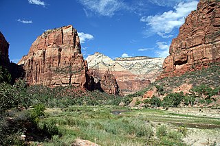
Bryce Canyon National Park is an American national park located in southwestern Utah. The major feature of the park is Bryce Canyon, which despite its name, is not a canyon, but a collection of giant natural amphitheaters along the eastern side of the Paunsaugunt Plateau. Bryce is distinctive due to geological structures called hoodoos, formed by frost weathering and stream erosion of the river and lake bed sedimentary rocks. The red, orange, and white colors of the rocks provide spectacular views for park visitors. Bryce Canyon National Park is much smaller, and sits at a much higher elevation than nearby Zion National Park. The rim at Bryce varies from 8,000 to 9,000 feet.
Morgan County is a county in northern Utah, United States. As of the 2010 census, the population was 9,469. Its county seat and largest city is Morgan. Morgan County is part of the Ogden-Clearfield, UT Metropolitan Statistical Area as well as the Salt Lake City-Provo-Orem, UT Combined Statistical Area.

Hells Canyon is a 10-mile-wide (16 km) canyon located along the border of eastern Oregon, a small section of eastern Washington and western Idaho in the United States. It is part of the Hells Canyon National Recreation Area and is North America's deepest river gorge at 7,993 feet (2,436 m). Notably, Hells Canyon runs deeper than the better-known Grand Canyon.

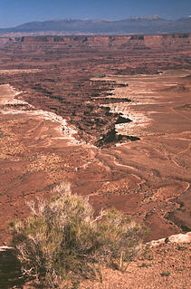
Canyonlands National Park is an American national park located in southeastern Utah near the town of Moab. The park preserves a colorful landscape eroded into numerous canyons, mesas, and buttes by the Colorado River, the Green River, and their respective tributaries. Legislation creating the park was signed into law by President Lyndon Johnson on September 12, 1964.

The Green River, located in the western United States, is the chief tributary of the Colorado River. The watershed of the river, known as the Green River Basin, covers parts of Wyoming, Utah, and Colorado. The Green River is 730 miles (1,170 km) long, beginning in the Wind River Mountains of Wyoming and flowing through Wyoming and Utah for most of its course, except for 40 miles (64 km) into western Colorado. Much of the route is through the Colorado Plateau and through some of the most spectacular canyons in the United States. It is only slightly smaller than the Colorado when the two rivers merge, but typically carries a larger load of silt. The average yearly mean flow of the river at Green River, Utah is 6,121 cubic feet (173.3 m3) per second.
The Bear River is the largest tributary of the Great Salt Lake, draining a mountainous area and farming valleys northeast of the lake and southeast of the Snake River Plain. It flows through southwestern Wyoming, southeastern Idaho, and northern Utah, in the United States. Approximately 350 miles (560 km) long it is the longest river in North America that does not ultimately reach the sea.

The Bear River Range, is a mountain range located in northeastern Utah and southeastern Idaho in the western United States.

The Grand Valley is an extended populated valley, approximately 30 miles (48 km) long and 5 miles (8.0 km) wide, located along the Colorado River in Mesa County in western Colorado and Grand County in eastern Utah in the Western United States. The valley contains the city of Grand Junction, as well as other smaller communities such as Fruita and Palisade. The valley is a major fruit-growing region that contains many orchards and vineyards, and is home to one of two designated American Viticultural Areas in Colorado: the Grand Valley AVA. It takes its name from the "Grand River", the historical name of the Colorado River upstream from its confluence with the Green River that was used by locals in the late 19th and early 20th century. The valley is the most densely populated area on the Colorado Western Slope, with Grand Junction serving as an unofficial capital of the region, as a counterpoint to Denver on the eastern slope of the Rocky Mountains in the Colorado Front Range. Interstate 70 and U.S. Highway 6 run through the valley from west-to-east. The Grand Valley is part of the larger Colorado Plateau desert lands.
Zion Canyon is a deep and narrow gorge in southwestern Utah, United States, carved by the North Fork of the Virgin River. Nearly the entire canyon is located within the western half of Zion National Park.

The Cutler Formation or Cutler Group is a rock unit that is spread across the U.S. states of Arizona, northwest New Mexico, southeast Utah and southwest Colorado. It was laid down in the Early Permian during the Wolfcampian stage. Its subunits, therefore, are variously called formations or members depending on the publication. Members :

The Kaibab Limestone is a resistant cliff-forming, Permian geologic formation that crops out across the U.S. states of northern Arizona, southern Utah, east central Nevada and southeast California. It is also known as the Kaibab Formation in Arizona, Nevada, and Utah. The Kaibab Limestone forms the rim of the Grand Canyon. In the Big Maria Mountains, California, the Kaibab Limestone is highly metamorphosed and known as the Kaibab Marble.
Cottonwood Canyon may refer to:

Desolation Canyon is a remote canyon on the Green River in eastern Utah, United States that is listed on the National Register of Historic Places (NRHP). It is said to be one of the remotest areas in the contiguous United States.

Blanco Canyon is a canyon located in the U.S. state of Texas. Eroded by the White River into the Caprock Escarpment on the east side of the Llano Estacado, the canyon runs for 34 miles (55 km) in a southeasterly direction, gradually widening from its beginning in southwestern Floyd County to 10 miles (16 km) across at its mouth in southeastern Crosby County. It also gradually deepens from 50 feet (15 m) at its beginning to 300 to 500 feet at its mouth. One side canyon, 5-mile long Crawfish Canyon, was cut by Crawfish Creek as it feeds into the White River from the west.

The Ohanapecosh River is a 16-mile (26 km) river in the U.S. state of Washington.

Buckskin Mountain is a 16-mile (26 km) mountain ridge that spans from Coconino County, Arizona to Kane County, Utah in the United States, that is divided almost equally between the two counties.
The White Rim Sandstone is a sandstone geologic formation located in southeastern Utah. It is the last member of the Permian Cutler Group, and overlies the major Organ Rock Formation and Cedar Mesa Sandstone; and again overlies thinner units of the Elephant Canyon and Halgaito Formations.

Tapeats Creek is a creek located entirely within the Grand Canyon National Park. It flows southwest from its source near the North Rim of the canyon to the Colorado River at the base of the canyon. It was named by the Second Powell Expedition in the winter of 1871–1872 for a Southern Paiute Indian who claimed ownership of the stream. It contributes the largest amount of water to the Colorado of any tributary on the north side within the Grand Canyon.

Willow Creek is a major north-flowing stream in Utah, United States, and is a tributary of the Green River. The creek drains a large remote area of the East Tavaputs Plateau, flowing into the Green River south of Ouray.
Big Bend is a meander or bend in a deep canyon along the Colorado River, in Grand County, Utah. It lies within the bounds of Arches National Park at an elevation of 3,980 feet / 1,213 meters, 6.3 miles northeast of Moab, Utah.