
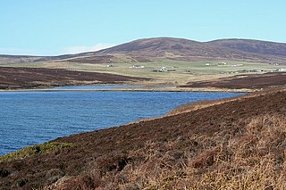
Stines Moss is an elevated bog in the southwest upland area of the Orkney Mainland, Scotland. [1]
Stines Moss is an elevated bog in the southwest upland area of the Orkney Mainland, Scotland. [1]
This moss is located a few miles south of very significant Neolithic and Iron Age archaeological sites. A few miles to the north are the Standing Stones of Stenness and the Ring of Brodgar. [2] About four miles to the northeast is the Iron Age Maes Howe site.
The Burn of Ayreland flows through this moss, and thence proceeds in a northwesterly direction to power the Mill of Ayreland before discharging to the Clestrain Sound. The mill functioned from the Late Middle Ages until at least the late 1880s and is now a country inn.

A broch is an Iron Age drystone hollow-walled structure found in Scotland. Brochs belong to the classification "complex Atlantic roundhouse" devised by Scottish archaeologists in the 1980s. Their origin is a matter of some controversy.

Orkney, also known as the Orkney Islands, is an archipelago in the Northern Isles of Scotland, situated off the north coast of the island of Great Britain. Orkney is 10 miles (16 km) north of the coast of Caithness and has about 70 islands, of which 20 are inhabited. The largest island, the Mainland, has an area of 523 square kilometres (202 sq mi), making it the sixth-largest Scottish island and the tenth-largest island in the British Isles. Orkney’s largest settlement, and also its administrative centre, is Kirkwall.

Hoy is an island in Orkney, Scotland, measuring 143 square kilometres (55 sq mi) – the second largest in the archipelago, after Mainland. A natural causeway, the Ayre, links the island to the smaller South Walls; the two islands are treated as one entity by the UK census.

Rousay is a small, hilly island about 3 km (1.9 mi) north of Mainland, the largest island in the Orkney Islands of Scotland. It has been nicknamed "Egypt of the north", due to its archaeological diversity and importance.

The Brough of Birsay is an uninhabited tidal island off the north-west coast of The Mainland of Orkney, Scotland, in the parish of Birsay. It is located around 13 miles north of Stromness and features the remains of Pictish and Norse settlements as well as a modern light house.
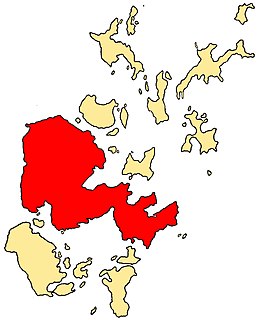
The Mainland, also known as Hrossey and Pomona, is the main island of Orkney, Scotland. Both of Orkney's burghs, Kirkwall and Stromness, lie on the island, which is also the heart of Orkney's ferry and air connections.

Eday is one of the islands of Orkney, which are located to the north of the Scottish mainland. One of the North Isles, Eday is about 24 kilometres from the Orkney Mainland. With an area of 27 km2 (10 sq mi), it is the ninth-largest island of the archipelago. The bedrock of the island is Old Red Sandstone, which is exposed along the sea-cliffs.
South Ronaldsay is one of the Orkney Islands off the north coast of Scotland. It is linked to the Orkney Mainland by the Churchill Barriers, running via Burray, Glimps Holm and Lamb Holm.
Burray is one of the Orkney Islands in Scotland. It lies to the east of Scapa Flow and is one of a chain of islands linked by the Churchill Barriers.
Mine Howe is an Iron Age subterranean man-made chamber dug 6 meters deep inside a large mound. It is located in the Tankerness area of Orkney, Scotland, about 5 miles (8 km) southeast of Kirkwall, the capital of Orkney. The origin of the howe is not perfectly understood. Experts believe that it was built roughly 2000 years ago during the Iron Age. There is some similarity to the well inside the Iron Age Broch of Gurness.

The Burn of Ayreland is a northwesterly flowing coastal stream on Mainland Orkney, Scotland, that discharges to the Clestrain Sound about two miles south of Stenness. Draining chiefly agricultural lands elevated mosses and moorland. This stream has a notable lack of turbidity and a pH level of approximately 8. Armouring of the stream bottom consists of pebbles, cobbles and occasional boulders.
Clestrain Sound is a strait between Mainland Orkney and the Isle of Graemsay within the Orkney Islands, Scotland.

Mor Stein is a neolithic standing stone in the southeastern part of the island of Shapinsay, Orkney Islands, Scotland. Shapinsay is one of the two large inner islands of the Orkney group, and it is situated approximately two miles north of the Orkney Mainland. Linton Bay is situated slightly to the northeast of Mor Stein.
Waulkmill Bay is a tidal bay on the southwest of Mainland Orkney, Scotland. This bay and its immediately surrounding area have been identified as a Site of Special Scientific Interest by Scottish Natural Heritage.
The Mill of Ayreland is an historic watermill driven by water force of the Burn of Ayreland, a northwesterly flowing coastal stream within Mainland Orkney, Scotland, that empties into the Clestrain Sound approximately five kilometres southerly of Stenness.
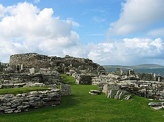
The Broch of Gurness is an Iron Age broch village on the northeast coast of Mainland Orkney in Scotland overlooking Eynhallow Sound, about 15 miles north-west of Kirkwall. It once housed a substantial community.

Holm is a parish on Mainland, Orkney.

Prehistoric Orkney refers only to the prehistory of the Orkney archipelago of Scotland that begins with human occupation. Although some records referring to Orkney survive that were written during the Roman invasions of Scotland, “prehistory” in northern Scotland is defined as lasting until the start of Scotland's Early Historic Period.
Broch of Ayre, also known as St. Mary's Broch, is an Iron Age broch in Orkney, Scotland.
Coordinates: 58°57′36″N3°11′17″W / 58.96000°N 3.18806°W
| | This Orkney location article is a stub. You can help Wikipedia by expanding it. |