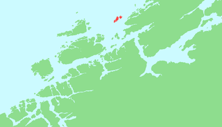
Stjørnfjord

Last updated
Stjørnfjorden

Sorfjorden.jpeg

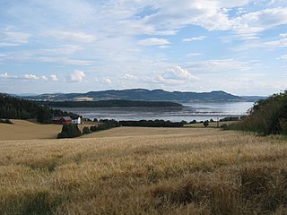
View of the inner part of the fjord
Norway Trondelag adm location map.svg
Red pog.svg
Stjørnfjorden
Location of the fjord
Relief Map of Norway.png
Red pog.svg
Stjørnfjorden
Stjørnfjorden (Norway)
Location Trøndelag county, Norway
Coordinates 63°42′36″N9°51′50″E / 63.7101°N 09.8638°E / 63.7101; 09.8638 Coordinates: 63°42′36″N9°51′50″E / 63.7101°N 09.8638°E / 63.7101; 09.8638
Type Fjord
Primary inflows Nordelva river
Primary outflows Trondheimsfjorden
Basin  countries Norway
Max. length 20 kilometres (12 mi)
Max. width 6 kilometres (3.7 mi)
Settlements Råkvåg

The Stjørnfjord or Stjørnfjorden is an arm of Trondheimsfjorden that flows through the municipalities of Bjugn, Ørland, and Indre Fosen in Trøndelag county, Norway. The 20-kilometre (12 mi) long fjord stretches southwest from the mouth of the Nordelva river near the village of Råkvåg to the Trondheimsfjord near Brekstad and Austrått. The inner part of the fjord splits into two smaller arms, the Nordfjord and Sørfjord. The Bjugnfjorden lies about 6 kilometres (3.7 mi) north of the fjord. [1]

Bjugn Municipality in Trøndelag, Norway

Bjugn is a municipality in Trøndelag county, Norway. It is part of the Fosen region. The village of Botngård is the administrative centre of Bjugn municipality. Other villages in Bjugn include Høybakken, Jøssund, Lysøysundet, Nes, Oksvoll, and Vallersund. Bjugn was on the Robek-list in 2015.

Ørland Municipality in Trøndelag, Norway

Ørland is a municipality in Trøndelag county, Norway. It is part of the Fosen region. Ørland is located at the southwestern tip of the Fosen peninsula at the northern shore of the mouth of Trondheimsfjord where the Stjørnfjorden arm begins. The administrative centre of the municipality is the city of Brekstad, which declared itself to be a city in 2005. Some of the villages in Ørland include Uthaug, Opphaug, and Ottersbo.

Indre Fosen Municipality in Trøndelag, Norway

Indre Fosen is a municipality in Trøndelag county, Norway. It is located in the traditional district of Fosen. The administrative centre of the municipality is the village of Årnset. Other villages in Indre Fosen include Askjem, Dalbygda, Hasselvika, Husbysjøen, Leira, Leksvik, Råkvåg, Rørvika, Seter, Stadsbygd, and Vanvikan. The Norwegian County Road 755 runs through the municipality.

The village of Austrått, which includes the Austrått manor, is located on the northern shore near the outlet of the Stjørnfjorden into the Trondheimsfjord. A little further into the fjord lies the village of Stjørna, after which the fjord is named. The village of Høybakken and Heggvik Church lie on the north side of the fjord. On the south side is Fevåg on the far side of Bakstein point. Skerries stick up where the fjord parts into two arms. The village of Råkvåg is located on the south side of the Nordfjord, while the village of Mælan is located at the terminus of the Sørfjord.

Austrått manor in Ørland municipality, Norway

Austrått or Austrått Manor is a manor in Ørland municipality in Trøndelag county, Norway. Since the 10th century, Austrått has been the residence for many noblemen, noblewomen, and officials who played a significant role in Norwegian history. In historical records, Austrått can also be found written as Østråt, Østeraat, Østeraad, Austaat, and Austråt.

Stjørna Former municipality in Sør-Trøndelag, Norway

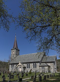
Stjørna is a former municipality in the old Sør-Trøndelag county in Norway. The municipality existed from 1899 until its dissolution in 1964. The 322-square-kilometre (124 sq mi) municipality encompassed the land surrounding the Stjørnfjorden in what is now the municipalities of Bjugn and Indre Fosen in Trøndelag county. The administrative centre of Stjørna was the village of Husbysjøen. The municipality of Stjørna also included the villages of Høybakken, Råkvåg, and Fevåg. The main church for the municipality was Stjørna Church which is now called Heggvik Church.

Høybakken Village in Central Norway, Norway

Høybakken is a village in the municipality of Bjugn in Trøndelag county, Norway. It is located along the Stjørnfjorden, about 5 kilometres (3.1 mi) south of the municipal center of Botngård. The area was once part of the municipality of Stjørna. The village is home to the Heggvik Church.

Norwegian County Road 718 goes along the south shore of the fjord, while Norwegian County Road 231 goes along a portion of the north shore.

Related Research Articles

Rissa, Norway Former municipality in Sør-Trøndelag, Norway

Rissa is a former municipality in the old Sør-Trøndelag county in Norway in the Fosen region. The municipality existed from 1860 until its dissolution on 1 January 2018 when it became part of the municipality of Indre Fosen in Trøndelag county. The administrative centre of the municipality was the village of Årnset. Other villages in the municipality included Askjem, Hasselvika, Husbysjøen, Rørvika, Råkvåg, and Stadsbygd.

Mosvik Former municipality in Nord-Trøndelag, Norway

Mosvik is a former municipality in the old Nord-Trøndelag county in Norway. The municipality was part of the Innherred region. The 219.37-square-kilometre (84.70 sq mi) municipality existed from 1901 until its dissolution in 2012. The old municipality encompassed the southern part of what is now the municipality of Inderøy in Trøndelag county. The municipality was located along the western shore of the Trondheimsfjorden and on the southwestern end of the Beitstadfjorden.

Trondheim Fjord inlet of the Norwegian Sea in Norway

The Trondheim Fjord or Trondheimsfjorden, an inlet of the Norwegian Sea, is Norway's third-longest fjord at 130 kilometres (81 mi) long. It is located in the west-central part of the country in Trøndelag county, and it stretches from the municipality of Ørland in the west to the municipality of Steinkjer in the north, passing the city of Trondheim on its way. Its maximum depth is 617 metres (2,024 ft), between Agdenes and Indre Fosen.

Follafoss Village in Central Norway, Norway

Follafoss is a village in the municipality of Verran in Trøndelag county, Norway. The village lies on the northern shore of the Beitstadfjorden, about halfway between the east and west end of the fjord. Follafoss village is about 12 kilometres (7.5 mi) southwest of the village of Malm and about 15 kilometres (9.3 mi) northeast of the village of Verrastranda. The Follaelva river empties into the Trondheimsfjord at Follafoss. The lakes Holden and Selavatnet both feed the river and also provide power through the Nord-Trøndelag Elektrisitetsverk power company through hydroelectric power from the dams on the lakes.

Ottersbo Village in Central Norway, Norway

Ottersbo is a village in the municipality of Ørland in Trøndelag county, Norway. It is located along the Stjørnfjorden, about 1 kilometre (0.62 mi) east of the Austrått manor near the border with Bjugn municipality.

Råkvåg Village in Central Norway, Norway

Råkvåg, or Råkvågen is a village in the municipality of Indre Fosen in Trøndelag county, Norway. It is located at the inner part of the Stjørnfjorden in the northern part of what was the old municipality of Rissa. It is about 4 kilometres (2.5 mi) north of the village of Husbysjøen and about 10 kilometres (6.2 mi) east of the village of Høybakken in the neighboring municipality of Bjugn. The Ramsvik Church lies just south of the village.

Husbysjøen Village in Central Norway, Norway

Husbysjøen is a village in the municipality of Indre Fosen in Trøndelag county, Norway. It was the administrative centre of the former municipality of Stjørna prior to its merger into neighboring Rissa municipality in 1964.

Brekstad Town in Central Norway, Norway

Brekstad is the administrative centre of the municipality of Ørland in Trøndelag county, Norway. The town is located along the Trondheimsfjord at the entrance to the Stjørnfjorden. The town is located about 5 kilometres (3.1 mi) south of the village of Uthaug and about 7 kilometres (4.3 mi) west of the villages of Austrått and Ottersbo.

Verrastranda Village in Central Norway, Norway

Verrastranda is a village located in the municipality of Verran in Trøndelag county, Norway. It is located on the north shore of the Verrasundet arm of the Trondheimsfjord. The village of Verrabotn lies about 20 kilometres (12 mi) to the southwest and the village of Follafoss lies about 15 kilometres (9.3 mi) to the northeast. Norwegian National Road 720 runs through the village. Verrastranda has a primary school.

Tarva (Norway) archipelago in Trøndelag, Norway

The Tarva islands are an archipelago in the municipality of Bjugn in Trøndelag county, Norway. The largest and only populated island is Husøya and the other larger islands are Været and Karlsøya. There are also many smaller surrounding islets and skerries. The islands are located about 8 kilometres (5.0 mi) west of the village of Nes on the mainland in Bjugn. Tarva is connected to the mainland via the Dybfest–Tarva Ferry.

Bjugnfjorden fjord in Trøndelag, Norway

The Bjugnfjorden is a fjord in the municipalities of Bjugn and Ørland in Trøndelag county, Norway. The 14-kilometre (8.7 mi) long fjord begins at the village of Botngård and it heads to the west past the Kjeungskjær Lighthouse into the Atlantic Ocean. Other villages along the fjord include Nes and Uthaug. Bjugn Church is located on the southern shore of the fjord. The Stjørnfjorden lies about 6 kilometres (3.7 mi) south of it, on the other side of the Ørlandet peninsula.

Bjugn Church Church in Trøndelag, Norway

Bjugn Church is a parish church in Bjugn municipality in Trøndelag county, Norway. It is located along the Bjugnfjorden about 5 kilometres (3.1 mi) west of the village of Botngård. It is the main church for the Bjugn parish which is part of the Fosen prosti (deanery) in the Diocese of Nidaros.

Heggvik Church Church in Trøndelag, Norway

Heggvik Church or Stjørna Church is a parish church in Bjugn municipality in Trøndelag county, Norway. It is located along the Stjørnfjorden in the village of Høybakken, about 5 kilometres (3.1 mi) south of the village of Botngård. It is one of the churches for the Bjugn parish which is part of the Fosen prosti (deanery) in the Diocese of Nidaros.

Ingdalen Village in Central Norway, Norway

Ingdalen is a village in the municipality of Agdenes in Trøndelag county, Norway. The village lies along the western shore of the Trondheimsfjord about 6.5 kilometres (4.0 mi) south of the villages of Lensvik and Selbekken. Ingdal Chapel is located in the village. The village was once a part of the municipality of Stadsbygd which included land on both sides of the fjord, but in 1964 the Ingdalen area was separated from Stadsbygd and merged into Agdenes which was on the same side of the fjord. The lake Øyangsvatnet lies about 10 kilometres (6.2 mi) west of the village.

Beitstadfjorden fjord in Trøndelag, Norway

Beitstadfjorden is the innermost arm of the Trondheimsfjord in Trøndelag county, Norway. It is located in the municipalities of Steinkjer, Inderøy, and Verran. The fjord has a length of 28 kilometres (17 mi) from southwest to northeast, and a width of about 6 to 8 kilometres.

Nordfjorden (Sogn og Fjordane) fjord in Sogn og Fjordane, Norway

Nordfjorden is the sixth longest fjord in Norway and the second longest fjord in all of Sogn og Fjordane county. It flows through the municipalities of Stryn, Gloppen, Eid, Bremanger, and Vågsøy, and it is the central feature of the entire Nordfjord region which makes up the northern third of the county.

References

  1. "Stjørnfjorden, Bjugn (Trøndelag)" (in Norwegian). yr.no . Retrieved 2018-02-24.