In British town planning, the green belt is a policy for controlling urban growth. The term, coined by Octavia Hill in 1875, refers to a ring of countryside where urbanisation will be resisted for the foreseeable future, maintaining an area where local food growing, forestry and outdoor leisure can be expected to prevail. The fundamental aim of green belt policy is to prevent urban sprawl by keeping land permanently green, and consequently the most important attribute of green belts is their openness.

The Borough of Runnymede is a local government district with borough status in Surrey, England. Its council is based in Addlestone and the borough also includes the towns of Chertsey and Egham. The borough is named after Runnymede, a water meadow on the banks of the River Thames near Egham, which is connected with the sealing of Magna Carta by King John in 1215.

The home counties are the counties of England that surround London. The counties are not precisely defined but Berkshire, Buckinghamshire, Hertfordshire, Essex, Kent and Surrey are usually included in definitions as, except Berkshire, they all border London. Other counties slightly further from London – such as Bedfordshire, Cambridgeshire, Hampshire, Oxfordshire, East Sussex and West Sussex – are not always regarded as home counties, although on occasion may be thought of as such due to their proximity to London and their connection to the London regional economy.

The County of London was a county of England from 1889 to 1965, corresponding to the area known today as Inner London. It was created as part of the general introduction of elected county government in England, by way of the Local Government Act 1888. The Act created an administrative County of London, which included within its territory the City of London. However, the City of London and the County of London formed separate ceremonial counties for "non-administrative" purposes. The local authority for the county was the London County Council (LCC), which initially performed only a limited range of functions, but gained further powers during its 76-year existence. The LCC provided very few services within the City of London, where the ancient Corporation monopolised local governance. In 1900, the lower-tier civil parishes and district boards were replaced with 28 new metropolitan boroughs. The territory of the county was 74,903 acres (303.12 km2) in 1961. During its existence, there was a long-term decline in population as more residents moved into the outer suburbs; there were periodic reviews of the local government structures in the greater London area and several failed attempts to expand the boundaries of the county. In 1965, the London Government Act 1963 replaced the county with the much larger Greater London administrative area.

The London metropolitan area is the metropolitan area of London, England. It has several definitions, including the London Travel to Work Area, and usually consists of the London urban area, settlements that share London's infrastructure, and places from which it is practicable to commute to work in London. It is also known as the London commuter belt, or Southeast metropolitan area.
Elmbridge is a local government district with borough status in Surrey, England. Its council is based in Esher, and other notable towns and villages include Cobham, Walton-on-Thames, Weybridge and Molesey. The borough lies just outside the administrative boundary of Greater London, but is almost entirely within the M25 motorway which encircles London. Many of the borough's urban areas form part of the wider Greater London Built-up Area.
Long Ditton is a residential suburb in the borough of Elmbridge, Surrey, England on the boundary with the Royal Borough of Kingston upon Thames, London. In medieval times it was a village, occupying a narrow strip of land. Neighbouring settlements include Hinchley Wood, Thames Ditton and Surbiton.

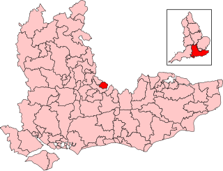
Runnymede and Weybridge is a constituency in Surrey represented in the House of Commons of the UK Parliament since 2019 by Ben Spencer, a Conservative.
Esher and Walton is a constituency in Surrey represented in the House of Commons of the UK Parliament. Since 2024, it has been represented by Monica Harding of the Liberal Democrats. Prior to this, Dominic Raab of the Conservative Party, who served as deputy prime minister before resigning from that role in April 2023 due to bullying allegations, had served as the MP since 2010.

Claygate is an affluent suburban village in Surrey, England, 14 miles southwest of central London. It is the only civil parish in the borough of Elmbridge. Adjoining Esher and Hinchley Wood to the west and north respectively, and bordered by green belt land to the south and east, Claygate lies within the Greater London Built-up Area.

Penge was a civil parish and a local government district located to the southeast of London, England. It included the settlements of Penge, Anerley and part of Crystal Palace. It was part of the London postal district, Metropolitan Police District and, from 1933, the London Passenger Transport Area. In 1965 the urban district was abolished by the London Government Act 1963 and it became part of Greater London, being combined with other districts to form the London Borough of Bromley.

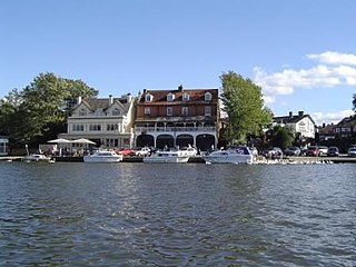
Molesey is a suburban district comprising two villages, East Molesey and West Molesey, in the Borough of Elmbridge, Surrey, England, and is situated on the south bank of the River Thames.
The Greater London Built-up Area, or Greater London Urban Area, is a conurbation in south-east England that constitutes the continuous urban sprawl of London, and includes surrounding adjacent urban towns as defined by the Office for National Statistics. It is the largest urban area in the United Kingdom with a population of 9,787,426 in 2011.
Esher Urban District was an urban district in Surrey, England created by merging two urban districts and adding two parishes to the south-west. It existed from 1933 to 1974 and was governed by the elected Esher Urban District Council which shared local government functions with Surrey County Council. Its main building was the large town hall in Esher.
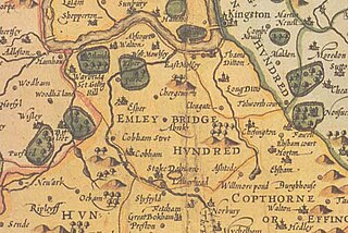
The Hundred of Elmbridge or Elmbridge/Emley Hundred was a geographic subdivision in the north of the county of Surrey, England. The majority of its area forms the modern Borough of Elmbridge, with the remainder forming part of the Royal Borough of Kingston upon Thames in Greater London.
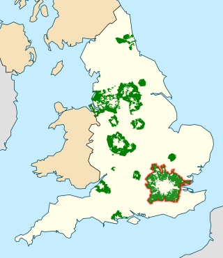
The Metropolitan Green Belt is a statutory green belt around London, England. It comprises parts of Greater London, Berkshire, Buckinghamshire, Essex, Hertfordshire, Kent and Surrey, parts of two of the three districts of Bedfordshire and a small area in Copthorne, Sussex. As of 2017/18, Government statistics show the planning designation covered 513,860 hectares of land.

A commuter town is a populated area that is primarily residential rather than commercial or industrial. Routine travel from home to work and back is called commuting, which is where the term comes from. A commuter town may be called by many other terms: "bedroom community", "bedroom town", "bedroom suburb" (US), "dormitory town" (UK). The term "exurb" was used from the 1950s, but since 2006, is generally used for areas beyond suburbs and specifically less densely built than the suburbs to which the exurbs' residents commute.
Visible minorities have become highly concentrated in Vancouver and its suburbs. The proportion of visible minorities in Vancouver increased from 14 percent to 55 percent of the population between 1981 and 2021. Vancouver has less residential segregation of its ethnic minorities compared to older Canadian cities such as Montreal. However, Vancouver exhibits some residential segregation, as demographic data shows visible minority concentrations vary by neighbourhood in Vancouver. In general, East Vancouver has higher visible minority concentrations than the West Side. Higher visible minority concentrations are also found in nearby suburbs such as Richmond, Surrey, Burnaby, and New Westminster. Most recent immigrants choose to locate in peripheral neighbourhoods in Greater Vancouver. It is speculated that Canada's multiculturalism policies may have prevented greater segregation from the dominant groups in both the residential location and the labour market.
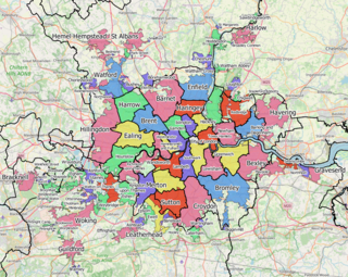
Greater London is an administrative area in England, coterminous with the London region, containing most of the continuous urban area of London. It contains 33 local government districts: the 32 London boroughs, which form a ceremonial county also called Greater London, and the City of London. The Greater London Authority is responsible for strategic local government across the region, and regular local government is the responsibility of the borough councils and the City of London Corporation. Greater London is bordered by the ceremonial counties of Hertfordshire to the north, Essex to the north-east, Kent to the south-east, Surrey to the south, and Berkshire and Buckinghamshire to the west.
Mindenhurst is a new neighbourhood in the village of Deepcut in Surrey, England, which is being built on the Princess Royal Barracks. It is in the London commuter belt giving families a rural lifestyle whilst being able to easily commute into the city. It will provide 1,200 new homes alongside 69 hectares of green space including woodlands. It will also have a number of amenities to support the new community.
