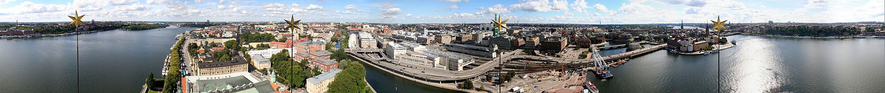
Stockholm City Centre

Last updated
Stockholm Municipality's boroughs: Stockholm City Centre covers the eastern third. The map also shows South Stockholm's and West Stockholm's boroughs. Stockholm boroughs 2007.svg
Stockholm Municipality's boroughs: Stockholm City Centre covers the eastern third. The map also shows South Stockholm's and West Stockholm's boroughs.

Stockholm City Centre (Stockholms innerstad, Innerstaden, Inre staden) is in Stockholm Municipality, also known as the City of Stockholm, part of the Stockholm urban area in Sweden.

Contents

Since 2007, Stockholm City Centre has been organized into four stadsdelsområden (sometimes translated as "boroughs"): Kungsholmen, Södermalm, Norrmalm, and Östermalm. [1] Before 2007, it was organized into five boroughs: Katarina-Sofia borough, Kungsholmen borough, Maria-Gamla stan borough, Norrmalm borough, and Östermalm borough.

The border between the historical provinces of Södermanland and Uppland splits Stockholm City Centre in two parts. 179,185 people live on an area of 28.05 km2 in the northern (Uppland) part, which gives a density of 6,388.06/km2.[ citation needed ] The same data for the southern (Södermanland) part is 103,646 people on 7.44 km2, giving a density of 13,930.91/km2.[ citation needed ] This border is purely historical and has no administrative significance.

Stockholm stadshuset.jpg
Stockholm City Centre

Districts

Sortable table
DistrictArea (ha) [2] Population
(31-12-2007)
Density (/ha) Borough Province
Djurgården 2907883 Östermalm Uppland
Fredhäll 384,958130 Kungsholmen Uppland
Gustav Vasa 8012,911161 Norrmalm Uppland
Gärdet 45918,15840 Östermalm Uppland
Hedvig Eleonora 5810,387179 Östermalm Uppland
Hjorthagen-Värtahamnen 1742,22513 Östermalm Uppland
Jakob 622013 Norrmalm Uppland
Klara 711,59722 Norrmalm Uppland
Kristineberg 635,57288 Kungsholmen Uppland
Kungsholm 10718,465173 Kungsholmen Uppland
Lilla Essingen 234,519196 Kungsholmen Uppland
Mariatorget 6214,099227 Maria-Gamla stan Södermanland
Marieberg 662,70041 Kungsholmen Uppland
Mellersta Högalid 549,914184 Maria-Gamla stan Södermanland
Norra Adolf Fredrik 193,816201 Norrmalm Uppland
Norra Johannes 669,043137 Norrmalm Uppland
Norra Högalid 6513,166203 Maria-Gamla stan Södermanland
Norra Sofia 587,721133 Katarina-Sofia Södermanland
Oscars Kyrka 11615,271132 Östermalm Uppland
Reimersholme-Långholmen 522,34945 Maria-Gamla stan Södermanland
Roslagstull 92,713301 Norrmalm Uppland
Stadshagen 632,25836 Kungsholmen Uppland
Stora Essingen 723,95455 Kungsholmen Uppland
Storkyrkan 423,01772 Maria-Gamla stan Södermanland
Stureplan-Lärkstaden 718,104114 Östermalm Uppland
Södra Adolf Fredrik 353,703106 Norrmalm Uppland
Södra Hammarbyhamnen 12510,61585 Katarina-Sofia Södermanland
Södra Högalid 724,15558 Katarina-Sofia Södermanland
Södra Johannes 152,011134 Norrmalm Uppland
Södra Sofia 7411,015149 Katarina-Sofia Södermanland
Södra Station 184,844269 Katarina-Sofia Södermanland
Tekniska Högskolan 1563,44222 Östermalm Uppland
Universitetet4763,1317 Östermalm Uppland
Västra Katarina 8513,220156 Katarina-Sofia Södermanland
Västra Matteus 8414,272170 Kungsholmen Uppland
Östra Katarina 8519,855234 Katarina-Sofia Södermanland
Östra Matteus 5112,325242 Kungsholmen Uppland
Östra Sankt Göran 5314,079266 Kungsholmen Uppland
Total3577296,32383

See also

Related Research Articles

<span class="mw-page-title-main">Södermanland</span> Historical province of Sweden

Södermanland, locally Sörmland, sometimes referred to under its Latin form Sudermannia or Sudermania, is a historical province or landskap on the south eastern coast of Sweden. It borders Östergötland, Närke, Västmanland and Uppland. It is also bounded by lake Mälaren and the Baltic Sea.

<span class="mw-page-title-main">Uppland</span> Historical province of Sweden

Uppland is a historical province or landskap on the eastern coast of Sweden, just north of Stockholm, the capital. It borders Södermanland, Västmanland and Gästrikland. It is also bounded by lake Mälaren and the Baltic Sea. On the small uninhabited island of Märket in the Baltic, Uppland has a very short and unusually shaped land border with Åland, an autonomous province of Finland.

<span class="mw-page-title-main">Geography of Stockholm</span>

The City of Stockholm is situated on fourteen islands and on the banks to the archipelago where Lake Mälaren meets the Baltic Sea. The city centre is virtually situated on the water.

<span class="mw-page-title-main">Söderort</span> Southern suburban part of the Stockholm Municipality, Sweden

Söderort is the southern suburban part of the Stockholm Municipality, Sweden. It is also part of the city of Stockholm.

<span class="mw-page-title-main">Västerort</span>

Västerort is the western part of Stockholm Municipality in Stockholm County, Sweden. It also forms part of Stockholm urban area and of Stockholm Metropolitan Area. It constitutes the western suburban area within Stockholm's municipal borders.

<span class="mw-page-title-main">Högdalen</span>

<span class="mw-page-title-main">Vasastan, Stockholm</span> District in central Stockholm, Sweden

Vasastan, or formally Vasastaden, is a 3.00 km2 large city district in central Stockholm, Sweden, being a part of Norrmalm borough.

<span class="mw-page-title-main">Östermalm</span> District Stockholm, Sweden

Östermalm is a 2.56 km2 large district in central Stockholm, Sweden. With 71,802 inhabitants, it is one of the most populous districts in Stockholm. It is an extremely expensive area, having the highest housing prices in Sweden.

<span class="mw-page-title-main">Norrmalm (borough)</span> Borough of Stockholm in Sweden

Norrmalm is a borough (stadsdelsområde) in central Stockholm, Sweden. It is named after the dominating district.

<span class="mw-page-title-main">Östermalm (borough)</span> Borough of Stockholm in Sweden

Östermalm is a borough (stadsdelsområde) in central Stockholm,Sweden. It is named after the dominating district. Except Östermalm (proper) there are four districts in the borough: Djurgården, Hjorthagen, Ladugårdsgärdet, and Norra Djurgården. Note that a portion of northern Östermalm is organized in Norrmalm borough. The population as of 2014 is 70,779 on an area of 18.00 km², which gives a density of 3,932.17/km².

<span class="mw-page-title-main">Mälaren Valley</span>

The Mälaren Valley, occasionally referred to as Stockholm-Mälaren Region (Stockholm-mälarregionen), is the easternmost part of Svealand, the catchment area of Lake Mälaren and the surrounding municipalities. The term is often used interchangeably for the extended capital region of Sweden as Stockholm is located at the lake's eastern end, at its outlet in the Baltic Sea.

<span class="mw-page-title-main">Kungsholmen</span> Island in the Lake Mälaren in Stockholm, Sweden

Kungsholmen is an island in Lake Mälaren in Sweden, part of central Stockholm, Sweden. It is situated north of Riddarfjärden and considered part of the historical province Uppland. Its area is 3.9 km2 (1.5 sq mi) with a perimeter of 8.9 km (5.5 mi). The highest point is at Stadshagsplan at 47 metres (154 ft). The total population is 71,542.

<span class="mw-page-title-main">Birger Jarlsgatan</span>

Birger Jarlsgatan is one of the longest streets in central Stockholm, Sweden. The street forms the border between Östermalm and the two neighbouring districts Norrmalm and Vasastaden.

<span class="mw-page-title-main">Barnhusbron</span>

Barnhusbron is a bridge in central Stockholm, Sweden. Passing over Barnhusviken, it connects Kungsholmen to Norrmalm. It is 23 metres wide and 290 metres long with a maximum span of 64.5 metres. The roadway is made of prestressed concrete except for two non-tensioned concrete section in its eastern end.

<span class="mw-page-title-main">Sankt Eriksbron</span>

Sankt Eriksbron is a bridge in central Stockholm, Sweden. Passing over Barnhusviken it connects Kungsholmen to Norrmalm. The present construction was inaugurated in 1937. Neighbouring bridges are: Kungsbron, Barnhusbron, Stadshusbron, Klarabergsviadukten, and Ekelundsbron.

<span class="mw-page-title-main">Uppland Runic Inscription 53</span>

Uppland Runic Inscription 53 is a runestone built into a wall in the intersection between the thoroughfares Prästgatan and Kåkbrinken in Gamla stan, the old town in central Stockholm, Sweden.

<span class="mw-page-title-main">Klara sjö</span>

Klara sjö is a canal in central Stockholm, Sweden.

<span class="mw-page-title-main">Barnhusviken</span>

Barnhusviken is a body of water in central Stockholm, Sweden. Separating the island Kungsholmen from the mainland district Norrmalm north of it, it connects Karlbergssjön to Klara Sjö.

Norr Mälarstrand is a street on Kungsholmen in central Stockholm, Sweden. Bordering Riddarfjärden, the easternmost bay of Lake Mälaren, Norr Mälarstrand is a southbound boulevard stretching 1,4 km (4.500 ft) west from the Stockholm City Hall to the southern end of the street Sankt Eriksgatan. The most notable structures along the street are the series of functionalist residential buildings lined-up along its western part. The park facing the waterfront south of the street is popular for walks.

Municipalities in Sweden are in some rare cases divided into smaller districts or urban districts, and are sometimes assigned administrative boards responsible for certain areas of governance in their respective areas. These districts are not specified by national Swedish law, but rather are created by individual municipalities, and thus the Swedish names of these districts vary greatly from municipality to municipality, including kommundelar, stadsdelar, stadsdelområden, primärområden, or stadsdelsnämndsområden. The degree of administrative autonomy of these districts similarly varies greatly, but is normally very limited.

References

  1. City of Stockholm: "Stockholm by districts" Archived December 18, 2008, at the Wayback Machine
  2. "Area and population density by City district". Stockholms stads utrednings- och statistikkontor AB. 2007-12-31. Archived from the original on July 20, 2011. Retrieved 2009-04-07.

59°19′48″N18°03′00″E / 59.3300°N 18.0500°E / 59.3300; 18.0500