
The Stockholm Metro is a rapid transit system in Stockholm, the capital city of Sweden. Its first line opened in 1950 as the first metro line in the Nordic countries. Today, the system consists of three lines and 100 stations, of which 47 are underground and 53 above ground. The system is owned by Region Stockholm via SL, the public transport authority for Stockholm County. It is the only metro system in Sweden.

Storstockholms Lokaltrafik known as SL, (Greater Stockholm Local Transport) is the public transport organisation responsible for managing land-based public transport in Stockholm County, Sweden. SL oversees a network that includes the Tunnelbana metro, Pendeltåg commuter trains, buses, trams, local rail, and some ferry services.

Roslagsbanan is a narrow gauge commuter railway system in Roslagen, Stockholm County, Sweden. Its combined route length is 65 kilometres and there are 38 stations. It is built to the Swedish three foot gauge. The Storstockholms Lokaltrafik (SL) classifies it as "light rail" in its maps.

Stockholm commuter rail is the commuter rail system in Stockholm County, Sweden. The system is an important part of the public transport in Stockholm, and is controlled by Storstockholms Lokaltrafik. The tracks are state-owned and administered by the Swedish Transport Administration, while the operation of the Stockholm commuter rail services itself has been contracted to SJ AB since March 2024.

Stockholm Östra station, literally Stockholm East Station, is a railway station in Stockholm, Sweden. It serves as the terminus for the Roslagsbanan narrow-gauge railway system.

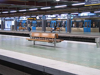
T-Centralen is the largest and busiest station on the Stockholm Metro. It is located in the Norrmalm district of central Stockholm, directly adjacent to Stockholm Central Station and Stockholm City commuter train station. T-Centralen is also the name of the terminus for the Spårväg City tram line.

The Stockholm City Line is a commuter railway tunnel beneath central Stockholm in Sweden which is used by the Stockholm Commuter Rail. The line is 7.4 kilometres (4.6 mi) long, double track and electrified. It has two stations: Stockholm City Station is located directly below T-Centralen, the central station of the Stockholm Metro. The Odenplan station is the other station, and is also served by the Green Line of the Metro. The line opened on 10 July 2017.

Stockholm Södra is a railway station located in the Södermalm area of Stockholm, Sweden. Informally known as Södra Station, it is part of the Stockholm commuter rail (Pendeltåg) network. The station originally opened in 1860 as the northern terminus of the Västra Stambanan railway line but has since undergone redevelopment a number of times.
Liljeholmen is a Stockholm metro station in the city's southern Liljeholmen district. It is on the Red line. The station is also an interchange with the Tvärbanan tramway, and a bus terminal. Liljeholmen metro station is also connected to Nybodadepån, a depot/garage for subway trains and buses, which is located in the south part of Liljeholmen. Liljeholmen will also serve as an interchange station on the Metro's Yellow Line, which is expected to open by 2035.
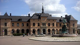
Uppsala Central Station is a railway station in Uppsala, Sweden. It lies on the East Coast Line, which runs south to Stockholm and north to Gävle and Sundsvall. It is also the southeastern terminus for the Dala Line which runs northwest ending in Mora. There are frequent commuter services to Stockholm. Long-distance trains, such as the SJ 3000, connect Uppsala to the northern parts of the country. Many trains, including the Stockholm commuter rail (Pendeltåg), also leave the main line to connect Uppsala with Stockholm-Arlanda Airport. Next to the station is a hub for the regional coach services operated by Upplands Lokaltrafik. Many local bus routes run through or near the station grounds as well, and there is a large area set aside for bicycle parking.

Gamla stan is a station on the Green and Red lines of the Stockholm metro. It is located on the western side of the Gamla stan district of central Stockholm, and is at ground level, although partly under the Centralbron bridge that carries road and mainline rail across the waterways that define the centre of the city. The same waterways are responsible for the ground level location of the station, unusual for a city centre metro station, as the lines cross between the islands of Stadsholmen and Södermalm by a bridge immediately south of the station.

Östermalmstorg metro station is station on the red line of the Stockholm metro, located in the district of Östermalm. The station was opened on 16 May 1965 as the 59th station in the Stockholm system as the north terminus of the extension from T-Centralen. On 2 September 1967, the line was extended northeast to Ropsten. On 30 September 1973, another extension, north to Tekniska högskolan, was opened. The platform is approximately 38 metres (125 ft) below the surface. It is located in the city center, making it one of the most-used stations in the system, with approximately 38,550 people travelling from the station on an average workday.

Fridhemsplan metro station is a station of the Stockholm metro, located in the district of Kungsholmen. The station is entirely underground and provides an interchange between the Blue and Green lines. There are two platforms for each line, about a hundred metres apart.

Hötorget, formerly known as Kungsgatan, is an underground station on the Green line of the Stockholm metro. It is situated near to the Hötorget square in the borough of Norrmalm in central Stockholm, and lies below Sveavägen between its junctions with Oxtorgsgatan and Apelbergsgatan. The station has three entrances, one at each end and one in the middle from Kungsgatan. The central entrance includes an underground square with several shops and stores. The distance to Slussen is 1.5 km (0.93 mi).

Odenplan is a station on both the Green Line of the Stockholm Metro and the City Line of the Pendeltåg commuter rail network which is called Stockholm Odenplan. It is located at Odenplan in Vasastan, in central Stockholm.

Arlanda Central Station or Arlanda C is a railway station on the Arlanda Line serving Stockholm Arlanda Airport in Sweden. It is served by various regional, intercity, and night trains operated by SJ, Mälartåg and Vy Tåg and since December 2012 also by Stockholm commuter rail.

The Red line, is one of the three Stockholm Metro lines. It has a total of 36 stations, of which four are cut and cover, 16 are tunneled, and 15 are on the surface. The line is a total of 41.238 kilometres (25.624 mi) long. It consists of four branches with terminals in Fruängen and Norsborg in the southwest and Mörby centrum and Ropsten in the northeast.

The Blue line is one of the three Stockholm Metro lines. It is 25.5 kilometres long, and runs from Kungsträdgården via T-Centralen to Västra skogen where it branches in two, and continues to Hjulsta and Akalla as lines 10 and 11 respectively.

The Green Line is the oldest of the three Stockholm Metro lines. The 41.256-kilometre (25.635 mi) long line comprises a single double-tracked line north of the city centre, splitting into three branches south of the city centre. The first section of the line opened as a metro in 1950, making it the first and oldest metro line in the Nordic countries, although some parts of the line date back to the 1930s and were originally used by the Stockholm tramway.

Karlberg Station is a disused a commuter rail station located in Stockholm, Sweden. It served as a part of the Stockholm commuter rail network from its opening in 1882 until its closure on 10 July 2017. Following the inauguration of the Citybanan railway tunnel, Karlberg Station was replaced by Stockholm Odenplan station. The station has been retained for use as a reserve station.


