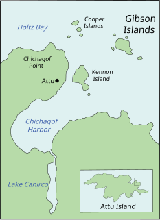
The Gibson Islands are a group of small islands that extend for 0.3 mi into the mouth of Chichagof Harbor on the northeast side of Attu Island in the Aleutians West Census Area of the U.S. state of Alaska. The islands were named in July 1855 by the North Pacific Surveying Expedition for Lt. William Gibson, USN, commander of the schooner USS Fenimore Cooper.

Sandspit is the largest community on Moresby Island, in Haida Gwaii off the Pacific coast of British Columbia, Canada. The unincorporated community had a population of 297 as of the 2016 census, down from 387 in 2006. The community is served by Sandspit Airport with flights to Vancouver.

Amgun River is a river in Khabarovsk Krai, Russia that flows northeast and joins the Amur River from the left near its mouth. The length of the river is 723 kilometres (449 mi). The area of its basin is 55,500 square kilometres (21,400 sq mi). The Amgun is formed by the confluence of the Ayakit and Suduk Rivers. Its main tributary is the Nimelen River. The Amgun teems with fish, such as Siberian salmon, humpback salmon, sturgeon, and carp. The Baikal Amur Mainline railway enters the Amgun River valley from the Dusse-Alin Tunnel and follows the river 180 kilometres (110 mi) northeast to Berezovyy where it turns southeast to Komsomolsk.

Zhag'yab County, also spelled Chagyab, is a county of the Chamdo Prefecture in the Tibet Autonomous Region, China. One of the villages in the county is Korra.

Aygezard is a town in the Ararat Province of Armenia.
Boniewo is a village in the administrative district of Gmina Fajsławice, within Krasnystaw County, Lublin Voivodeship, in eastern Poland.
Sacharki is a village in the administrative district of Gmina Michałowo, within Białystok County, Podlaskie Voivodeship, in north-eastern Poland, close to the border with Belarus. It is around 40 km south-east of the city of Białystok.
Chomizna is a village in the administrative district of Gmina Poświętne, within Białystok County, Podlaskie Voivodeship, in north-eastern Poland.
Józefin is a village in the administrative district of Gmina Poświętne, within Białystok County, Podlaskie Voivodeship, in north-eastern Poland.

Sumağavaqazma is a village in the Davachi Rayon of Azerbaijan. The village forms part of the municipality of Pirəbədil.
Köhnədaxar is a village in the Ismailli Rayon of Azerbaijan. The village forms part of the municipality of Qaraqaya.

Słupia Nadbrzeżna is a village in the administrative district of Gmina Tarłów, within Opatów County, Świętokrzyskie Voivodeship, in south-central Poland. It lies approximately 9 kilometres (6 mi) south-east of Tarłów, 31 km (19 mi) north-east of Opatów, and 84 km (52 mi) east of the regional capital Kielce.
Załęże-Sędzięta is a village in the administrative district of Gmina Różan, within Maków County, Masovian Voivodeship, in east-central Poland.
Brzóze Duże is a village in the administrative district of Gmina Rzewnie, within Maków County, Masovian Voivodeship, in east-central Poland.
Lubotyń-Morgi is a village in the administrative district of Gmina Stary Lubotyń, within Ostrów Mazowiecka County, Masovian Voivodeship, in east-central Poland.
Zielonki-Parcela is a village in the administrative district of Gmina Stare Babice, within Warsaw West County, Masovian Voivodeship, in east-central Poland. It lies approximately 2 kilometres (1 mi) west of Stare Babice, 4 km (2 mi) north of Ożarów Mazowiecki, and 13 km (8 mi) west of Warsaw.

Rymań is a village in Kołobrzeg County, West Pomeranian Voivodeship, in north-western Poland. It is the seat of the gmina called Gmina Rymań. It lies approximately 25 kilometres (16 mi) south of Kołobrzeg and 86 km (53 mi) north-east of the regional capital Szczecin.
Mallet, Paraná is a municipality in the state of Paraná in the Southern Region of Brazil.

Bromford Bridge Racecourse was a racecourse in the Bromford area of Birmingham, England.
St. Joseph's Convent School is one of the prominent CISCE schools in Varanasi, Uttar Pradesh, India.


