Oldřišov is a village in the Moravian-Silesian Region of the Czech Republic. It is part of micro-region Hlučínsko. It has around 1,300 inhabitants.

Jezbořice is a village in the Pardubice Region of the Czech Republic. It has around 320 inhabitants.
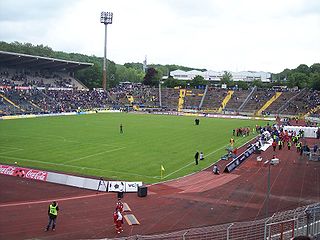
Ludwigsparkstadion is a multi-purpose stadium in Saarbrücken, Germany. It was built in 1953 and holds 35,303 people.

Nauener Platz is a Berlin U-Bahn station located on the U 9. The square that gives it its name is named after the city of Nauen.
Huanímaro is a Mexican city located in Southwest region of the state of Guanajuato. The municipality has an area of 130.57 square kilometres and is bordered to the north and west by Abasolo, to the south by the state of Michoacán, and to the east by Valle de Santiago. The municipality had a population of 19,693 inhabitants according to the 2005 census.

Kamimoku Station is a railway station on the Jōetsu Line in Numata, Gunma, Japan, operated by the East Japan Railway Company.
Nowa Wieś is a village in the administrative district of Gmina Izbica Kujawska, within Włocławek County, Kuyavian-Pomeranian Voivodeship, in north-central Poland.

Przytuły is a village in Łomża County, Podlaskie Voivodeship, in north-eastern Poland. It is the seat of the gmina called Gmina Przytuły. It lies approximately 27 kilometres (17 mi) north-east of Łomża and 64 km (40 mi) north-west of the regional capital Białystok.
Krasienin-Kolonia is a village in the administrative district of Gmina Niemce, within Lublin County, Lublin Voivodeship, in eastern Poland. It lies approximately 12 kilometres (7 mi) west of Niemce and 16 km (10 mi) north-west of the regional capital Lublin.
Jawor is a village in the administrative district of Gmina Mniszków, within Opoczno County, Łódź Voivodeship, in central Poland.
Zamek Kiszewski is a village in the administrative district of Gmina Stara Kiszewa, within Kościerzyna County, Pomeranian Voivodeship, in northern Poland. It lies approximately 2 kilometres (1 mi) east of Stara Kiszewa, 21 km (13 mi) south-east of Kościerzyna, and 52 km (32 mi) south-west of the regional capital Gdańsk.
Gęby is a settlement in the administrative district of Gmina Osiek, within Starogard County, Pomeranian Voivodeship, in northern Poland. It lies approximately 9 kilometres (6 mi) west of Osiek, 27 km (17 mi) south-west of Starogard Gdański, and 71 km (44 mi) south of the regional capital Gdańsk.
Brzezi Ostrów is a settlement in the administrative district of Gmina Sztum, within Sztum County, Pomeranian Voivodeship, in northern Poland. It lies approximately 4 kilometres (2 mi) west of Sztum and 56 km (35 mi) south-east of the regional capital Gdańsk.
Henrykowo is a settlement in the administrative district of Gmina Kętrzyn, within Kętrzyn County, Warmian-Masurian Voivodeship, in northern Poland.
Żabiniec is a settlement in the administrative district of Gmina Białogard, within Białogard County, West Pomeranian Voivodeship, in north-western Poland. It lies approximately 4 kilometres (2 mi) south-west of Białogard and 110 km (68 mi) north-east of the regional capital Szczecin.
Łatno is a village in the administrative district of Gmina Brojce, within Gryfice County, West Pomeranian Voivodeship, in north-western Poland. It lies approximately 4 kilometres (2 mi) north of Brojce, 14 km (9 mi) north-east of Gryfice, and 82 km (51 mi) north-east of the regional capital Szczecin.
Połczyno is a village in the administrative district of Gmina Lipiany, within Pyrzyce County, West Pomeranian Voivodeship, in north-western Poland.
Badaguichiri is a village and rural commune in Niger.
Argun is the name of several inhabited localities in Russia.
Fleetstreet is a theatre in Hamburg, Germany.


