
Mount Waddington, once known as Mystery Mountain, is the highest peak in the Coast Mountains of British Columbia, Canada. Although it is lower than Mount Fairweather and Mount Quincy Adams, which straddle the United States border between Alaska and British Columbia, Mount Waddington is the highest peak that lies entirely within British Columbia. It and the subrange which surround it, known as the Waddington Range, stand at the heart of the Pacific Ranges, a remote and extremely rugged set of mountains and river valleys.

TryfanWelsh pronunciation: [ˈtrəvan]) is a mountain in the Ogwen Valley, Snowdonia, Wales. It forms part of the Glyderau group, and is one of the most recognisable peaks in Britain, having a classic pointed shape with rugged crags. At 917.5 metres above sea level, it is the fifteenth-highest mountain in Wales. Tryfan was voted Britain's favourite mountain by Trail magazine.

Smith Rock State Park is a state park located in central Oregon's High Desert near the communities of Redmond and Terrebonne. The day-use area of the park is open daily from dawn to dusk. The park also has a camping area as well that accommodates tent camping only. Its sheer cliffs of tuff and basalt are ideal for rock climbing of all difficulty levels. Smith Rock is generally considered the birthplace of modern American sport climbing, and is host to cutting-edge climbing routes. It is popular for sport climbing, traditional climbing, multi-pitch climbing, and bouldering.

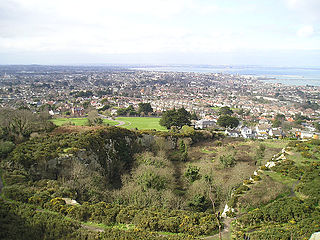
Tower Ridge is one of several ridges protruding north east from the summit plateau of Ben Nevis, the highest mountain in the United Kingdom.
Dalkey Quarry is a long-disused 19th century granite quarry located on Dalkey Hill in the Dublin suburb of Dalkey, which was used to build several large maritime structures in south Dublin. Since passing into public ownership in the early 20th century and becoming part of Killiney Hill Park, it has become one of the most important rock climbing venues in Ireland, with over 350 graded routes, some of which are amongst the hardest single-pitch rock climbs in the country such as Indecent Assault. The climbs are all traditional climbing routes and no bolted sport climbing routes are permitted, although some metal pegs are tolerated on the most extreme routes.

Pinnacle Peak is a granite summit located in Scottsdale, Arizona. The peak rises to an elevation of 3,169 feet (966 m). It is located within the 150-acre (61 ha) Pinnacle Peak Park, operated by the City of Scottsdale Park District. Part of the Sonoran Desert, the park is home to a variety of native desert flora and fauna. Hikers utilize a 1.75 mile trail to explore the area, though rock climbing skills are needed to reach the summit.

Big wall climbing is a form of rock climbing that takes place on long multi-pitch routes that normally require a full day, if not several days, to ascend. Big wall routes are typically sustained and exposed, where the climbers remain suspended from the rock face, even sleeping hanging from the face, with limited options to sit down or escape unless they abseil back down the whole route. It is therefore a physically and mentally demanding form of climbing.

The Durrance Route is a climbing route on Devils Tower in Wyoming, United States. First pioneered by Jack Durrance and Harrison Butterworth in September 1938, it was the second free ascent of Devils Tower, following the first ascent led by Fritz Wiessner in 1937. The Wiessner Route lies a few hundred feet to the right of the Durrance Route and has a comparable difficulty. Today the Durrance Route is the most popular route on Devils Tower. It is considered a more interesting and enjoyable route than the Wiessner Route, due to more variable terrain and better belay stances. The route is recognized in the historic climbing text, Fifty Classic Climbs of North America, and other guide books.

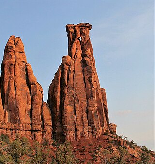
Fisher Towers are a series of towers made of Cutler sandstone capped with Moenkopi sandstone and caked with a stucco of red mud located near Moab, Utah. The Towers are named for a miner who lived near them in the 1880s. The Towers are world-renowned as a subject for photography and for its classic rock climbing routes.

Titan Tower, also known as The Titan, is the largest of the Fisher Towers near Moab and Castle Valley, Utah. It has also been attributed to be the largest, free-standing, natural tower in the United States. The tower contains the Finger of Fate Route, first climbed in 1962, which is recognized in the historic climbing text Fifty Classic Climbs of North America and considered a classic around the world.
Poke-O-Moonshine Mountain, spelled Pokamoonshine on U.S. Geological Survey maps, and sometimes known as just Poke-O, is a minor peak of the Adirondack Mountains. The name is believed to be a corruption of the Algonquin words pohqui, meaning 'broken', and moosie, meaning 'smooth'. It is located in the town of Chesterfield, New York, United States, on New York state Forest Preserve land, part of the Taylor Pond Wild Forest complex within the Adirondack Park. Due to its location next to the pass through which most travelers from the north enter the range, it has been called the "gateway to the Adirondacks".
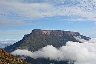
The Ilú–Tramen Massif is a tepui massif in Bolívar state, Venezuela. It is the northernmost member of the Eastern Tepuis chain and comprises two major plateaus: the larger Ilú-tepui to the south and Tramen-tepui to the north. With a maximum elevation of around 2,700 metres (8,900 ft), Ilú-tepui is the taller of the two peaks. Both tepuis have open, rocky summit plateaus, with a combined summit area of 5.63 km2 (2.17 sq mi). They lie just north of Karaurín-tepui.

Jan H. Conn and Herbert William Conn were climbing and caving pioneers. They are credited with establishing many classic climbs in areas like Carderock in Maryland, Seneca Rocks in West Virginia, Cannon Cliff in New Hampshire and Black Hills of South Dakota. They are also well known as cave explorers who in the 1960s and 1970s discovered and mapped over 60 miles of Jewel Cave, making it the world’s third-longest cave system.

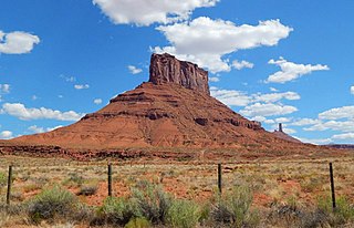
Parriott Mesa is a 6,155-foot-elevation sandstone summit in Grand County of Utah, United States. Parriott Mesa is located at Castle Valley, Utah, near the city of Moab. The name honors Dale M. Parriott (1885–1958), who was a Moab settler, and owned a ranch house in Castle Valley. Parriott Mesa is a thin 0.4 mile wide, and 1.5 mile long north-to-south mesa with 400 ft vertical Wingate Sandstone walls. Precipitation runoff from the mesa drains into the Colorado River which is about a mile away. The nearest higher peak is The Priest, 1.76 miles (2.83 km) to the east.
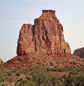
Convent Mesa, or The Convent, or simply Convent, are alternative names for a 5,955-foot elevation sandstone summit in Grand County of Utah, United States. The Convent is located in Professor Valley, near the city of Moab. It is situated northeast of Parriott Mesa and southwest of the Fisher Towers area. The Convent is a 1,000 feet wide, and 3,000 feet long northwest-to-southeast trending butte with 400-ft vertical Wingate Sandstone walls. The nearest higher peak is Sister Superior (6,037 ft), 0.91 miles (1.46 km) to the southeast. Further southeast along the connecting ridge are The Rectory and Castleton Tower. Precipitation runoff from The Convent drains into the nearby Colorado River. The first ascent of Convent was made in November 1965 by Harvey Carter and Steve Miller via the Salvation Chimney climbing route.
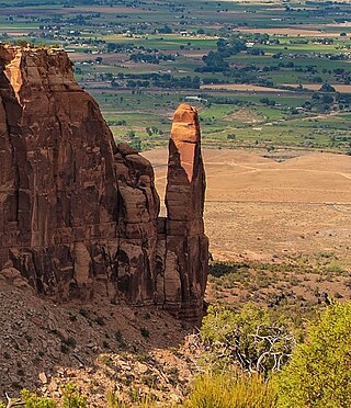
Independence Monument is a 5,739-foot-elevation sandstone pillar located in Colorado National Monument, in Mesa County of western Colorado, United States. This iconic 450-foot-high landmark is situated one mile southeast of the monument's visitor center, and 9 miles (14 km) west of the community of Grand Junction, where it towers above the floor of Monument Canyon and Wedding Canyon. It is a popular climbing destination, and can be seen from Rim Rock Drive.
Kissing Couple is a 5,815-foot-elevation (1,772-meter) sandstone pillar located in Colorado National Monument, in Mesa County of western Colorado, United States. This iconic 400-foot-high tower is situated on the west side of Monument Canyon, 1.5 mile southeast of the monument's visitor center, and 9 miles (14 km) west of the community of Grand Junction. It is also a half-mile south-southeast of another popular climbing destination, Independence Monument, and both can be seen from viewpoints along Rim Rock Drive. It is so named because it resembles an embracing couple. This geographical feature's name was officially adopted in 1982 by the United States Board on Geographic Names. Older USGS maps have the feature's name misplaced by about one-half mile to the southeast. The first ascent of the summit was made May 4, 1960, by Layton Kor, Harvey Carter, and John Auld via the five pitch, class 5.11a route named Long Dong Wall. The first free ascent was made in 1977 by Andy Petefish, Tom Stubbs, and Jim Pearson. Some climbers alternatively refer to Kissing Couple as "Bell Tower."

Pipe Organ is a 5,731-foot-elevation (1,747-meter) sandstone pillar located in Colorado National Monument, in Mesa County of western Colorado, United States. This 400+ foot tower is situated in Wedding Canyon, less than one-half mile east of the monument's visitor center, and 9 miles (14 km) west of the community of Grand Junction. It is also immediately northwest of another popular climbing destination, Independence Monument, and both can be seen from viewpoints along Rim Rock Drive. The first ascent of the summit was made January 31, 1961, by John Auld, Gary Ziegler, Jim Dyson, and John Kuglin. Pipe Organ has a subsidiary summit unofficially named Organ Pipe Spire on the east aspect, which the National Park Service refers to as Praying Hands. This 325-foot-high subsidiary peak was originally named Squall Spire in 1976 by Harvey T. Carter of the first ascent party.
Sentinel Spire is a 5,500-foot-elevation (1,700-meter) sandstone pillar located in Colorado National Monument, in Mesa County of western Colorado, United States. This 200-foot freestanding tower is situated in Wedding Canyon, one-half mile east of the monument's visitor center, and 9 miles (14 km) west of the community of Grand Junction. It is also immediately south of Window Rock, and north of another climbing destination, Pipe Organ, both of which can be seen from viewpoints along Rim Rock Drive. The first ascent of the summit was made May 3, 1960, by Layton Kor, Harvey Carter, and John Auld via the class 5.10 route, Fast Draw. This was the day before the climbers also made the first ascent of nearby Kissing Couple. The first solo ascent was made by Ron Olevsky in March 1976, and the first free ascent was made by Andy Petefish and John Christenson in 1978. Some climbers refer to Sentinel Spire as Watusi Spear.

Grand View Spire is a 5,821-foot-elevation (1,774-meter) sandstone pillar located in Colorado National Monument, in Mesa County of western Colorado, United States. This 400-foot tower is situated on the west side of Monument Canyon, one mile southeast of the monument's visitor center, and 9 miles (14 km) west of the community of Grand Junction. It is also 0.32 mile immediately south of Independence Monument, and 0.27 mile northwest of another climbing destination, Kissing Couple. Its unofficial name relates to its position at the tip of Grand View Overlook, one of several scenic viewpoints along Rim Rock Drive.

